Ficheiro:Abemama Map.jpg

Imagem numa resolução maior (5 310 × 5 667 píxeis, tamanho: 1,32 MB, tipo MIME: image/jpeg)
|
|
Esta imagem provém do Wikimedia Commons, um acervo de conteúdo livre da Wikimedia Foundation que pode ser utilizado por outros projetos.
|
Descrição do ficheiro
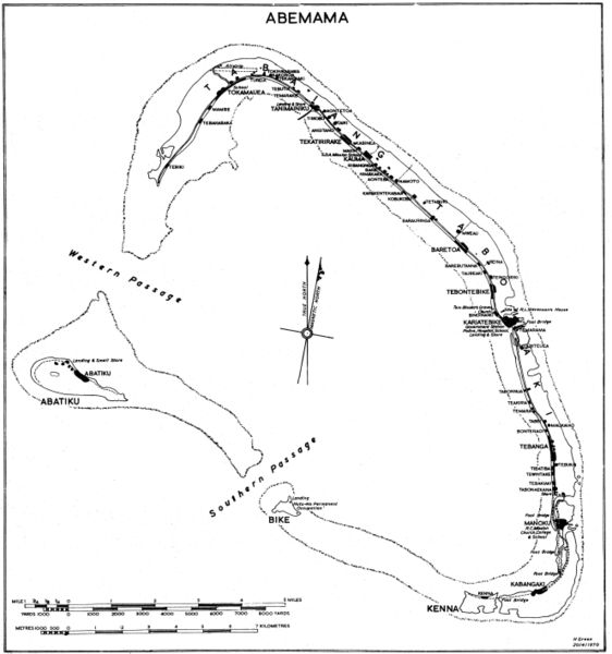
Government map (some maps in the series include the following: "Compiled by Lands and Surveys, Betio, Tarawa") with inscription "H Green 20/4/1970". Original obtained either directly from GEIDA of from a U.S. Government source (USACOE) as a blueline printing sometime in the 1970s. I believe these maps were produced for government use by the Gilbert Islands Colony. I have scanned and slightly altered the original (1/50,000 scale). Maps such as this one showing village locations on Pacific islands are difficult to come by. - Marshman 18:16, 28 November 2005 (UTC)
Licenciamento
Esta obra encontra-se no domínio público nos Estados Unidos por ser uma obra do Governo Federal dos EUA nos termos do Título 17, Capítulo 1, Secção 105 do US Code. Veja Copyright.
Nota: Este estatuto apenas se aplica a obras do Governo Federal, e não a obras de nenhum estado, condado, subdivisão ou município.
|
 | |
| Este ficheiro foi considerado livre de restrições conhecidas devidas a direitos de autor, incluindo todos os direitos conexos. | ||
Histórico do ficheiro
Clique uma data e hora para ver o ficheiro tal como ele se encontrava nessa altura.
| Data e hora | Miniatura | Dimensões | Utilizador | Comentário | |
|---|---|---|---|---|---|
| atual | 20h07min de 28 de novembro de 2005 | | 5 310 × 5 667 (1,32 MB) | Marshman~commonswiki | Slightly larger version of same |
| 18h13min de 28 de novembro de 2005 |  | 3 540 × 3 778 (708 kB) | Marshman~commonswiki | Government map with inscription "H Green 20/4/1970" I obtained the "original" as a blueline printing in the 1970s. I believe these maps were produced for government use by the Gilbert Islands Colony. I have scanned and slightly altered the original (1/50 |
Utilização local do ficheiro
A seguinte página usa este ficheiro:
Utilização global do ficheiro
As seguintes wikis usam este ficheiro:
- ce.wikipedia.org
- de.wikipedia.org
- el.wikipedia.org
- en.wikipedia.org
- es.wikipedia.org
- fi.wikipedia.org
- gl.wikipedia.org
- he.wikipedia.org
- hu.wikipedia.org
- ka.wikipedia.org
- mk.wikipedia.org
- ru.wikipedia.org