Ficheiro:Amazon-river-NASA.jpg

Dimensões desta antevisão: 600 × 600 píxeis. Outras resoluções: 240 × 240 píxeis | 480 × 480 píxeis | 768 × 768 píxeis | 1 024 × 1 024 píxeis | 2 048 × 2 048 píxeis | 4 096 × 4 096 píxeis.
Imagem numa resolução maior (4 096 × 4 096 píxeis, tamanho: 2,79 MB, tipo MIME: image/jpeg)
|
|
Esta imagem provém do Wikimedia Commons, um acervo de conteúdo livre da Wikimedia Foundation que pode ser utilizado por outros projetos.
|
Descrição do ficheiro
| Descrição |
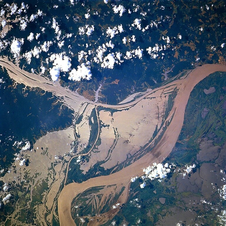
Afrikaans: STS078-751-094 Oorstroomde Amasonerivieroewers in westelike Pará-provinsie, Brasilië in Junie 1996. Die ligging is sowat halfpad tussen Manaus en die Amasonerivierdelta.
Hierdie beeld toon oorstroomde oewers van 'n klein segment van die Amasonerivier, insluitend die oerwouddorpies Oriximiná en Óbidos. Songlans op die modderige rivierwater fasiliteer die onderskeiding van land en water. Deur hierdie beeld met 'n gedetailleerde gebiedskaart te vergelyk, word dit duidelik dat die Amazonerivier sy oewers in die laagliggende dele aanliggend aan die vloedvlakte van die hoofkanaal oorstroom, en groot dele suid van die hoofkanaal staan ook onder (skoon) water. Ontbosde gebiede is binne die digbegroeide terrein aan die noordekant van die Amasonerivier waarneembaar. Die hoofkanaal van die Trombetasrivier kan suidooswaarts nagespeur word, van die linkerrand van die prent af, totdat die Trombetas tussen die oerwouddorpies Oriximiná en Óbidos met die Amasone saamvloei. English: A satellite image of a part of the Amazon River.
Esperanto: La bildo estas kopiita de wikipedia:en. La originala priskribo estas
English: Original caption: [altered to reflect rotation]
|
| Data | |
| Origem | http://earth.jsc.nasa.gov/sseop/EFS/photoinfo.pl?PHOTO=STS078-751-94 (file) |
| Autor | NASA |
| Localização do objecto | | Esta e outras imagens nas suas localizações em: OpenStreetMap |
|---|
Este(a) imagem ou vídeo foi catalogado(a) por um dos centros dos Estados Unidos da América para a Administração Nacional da Aeronáutica e do Espaço (NASA), sobre o código ID: STS078-751-94. Esta marcação não indica o estado dos direitos de autor da obra aqui mostrada. Continua a ser necessária uma marcação normal de direitos de autor. Veja Commons:Licenciamento para mais informações. Outras línguas:
|
Licenciamento
| Este ficheiro está no domínio público nos Estados Unidos porque foi criado exclusivamente pela NASA. As orientações sobre o direito de autor da NASA são que «as obras da NASA não têm os direitos de autor protegidos salvo indicação em contrário». Veja Template:PD-USGov, as orientações sobre o direito de autor da NASA ou as normas de uso de imagens do Laboratório de Propulsão a Jato (Jet Propulsion Lab, JPL). | ||
 |
Avisos:
|
Old file history
Transferred from English-Wikipedia:
| date/time | username | edit summary |
|---|---|---|
| 02:26, 6 January 2005 | en:User:Quadell | (tagged) |
| 18:08, 18 June 2004 | en:User:Sverdrup | (Image info) |
| 18:06, 18 June 2004 | en:User:Sverdrup | (A satellite image of a part of the <a href="/wiki/Amazon_River" title="Amazon River">Amazon River</a>) |
| Anotações | Esta imagem está anotada: Ver as anotações na wiki Commons |
Histórico do ficheiro
Clique uma data e hora para ver o ficheiro tal como ele se encontrava nessa altura.
| Data e hora | Miniatura | Dimensões | Utilizador | Comentário | |
|---|---|---|---|---|---|
| atual | 17h13min de 8 de dezembro de 2022 | | 4 096 × 4 096 (2,79 MB) | JMK | boost saturation, add some contrast |
| 17h10min de 8 de dezembro de 2022 |  | 4 096 × 4 096 (2,69 MB) | JMK | rotate 180, north up | |
| 10h10min de 10 de novembro de 2022 |  | 4 096 × 4 096 (15,22 MB) | Askeuhd | Higher resolution version | |
| 14h15min de 10 de outubro de 2012 |  | 640 × 640 (418 kB) | Rotatebot | Bot: Image rotated by 180° | |
| 14h39min de 29 de janeiro de 2006 |  | 640 × 640 (377 kB) | Maksim | La bildo estas kopiita de wikipedia:en. La originala priskribo estas: A satellite image of a part of the Amazon River. {{PD-USGov-NASA}} '''Original caption:''' :''STS078-751-094 Amazon River, Western Para Province, Brazil June 1996'' :''This image s |
Utilização local do ficheiro
As seguintes 2 páginas usam este ficheiro:
Utilização global do ficheiro
As seguintes wikis usam este ficheiro:
- ar.wikipedia.org
- ast.wikipedia.org
- azb.wikipedia.org
- ca.wikipedia.org
- ce.wikipedia.org
- cv.wikipedia.org
- en.wikipedia.org
- eo.wikipedia.org
- es.wikipedia.org
- eu.wikipedia.org
- fa.wikipedia.org
- fr.wikipedia.org
- fy.wikipedia.org
- id.wikipedia.org
- ilo.wikipedia.org
- kk.wikipedia.org
- krc.wikipedia.org
- ml.wikipedia.org
- mr.wikipedia.org
- nl.wikipedia.org
- no.wikipedia.org
- os.wikipedia.org
- pl.wiktionary.org
- rm.wikipedia.org
- ru.wikipedia.org
- uk.wikipedia.org
- vec.wikipedia.org
- vi.wikipedia.org
- www.wikidata.org
- zh-yue.wikipedia.org
- zh.wikipedia.org