Ficheiro:Three Mile Island (color).jpg
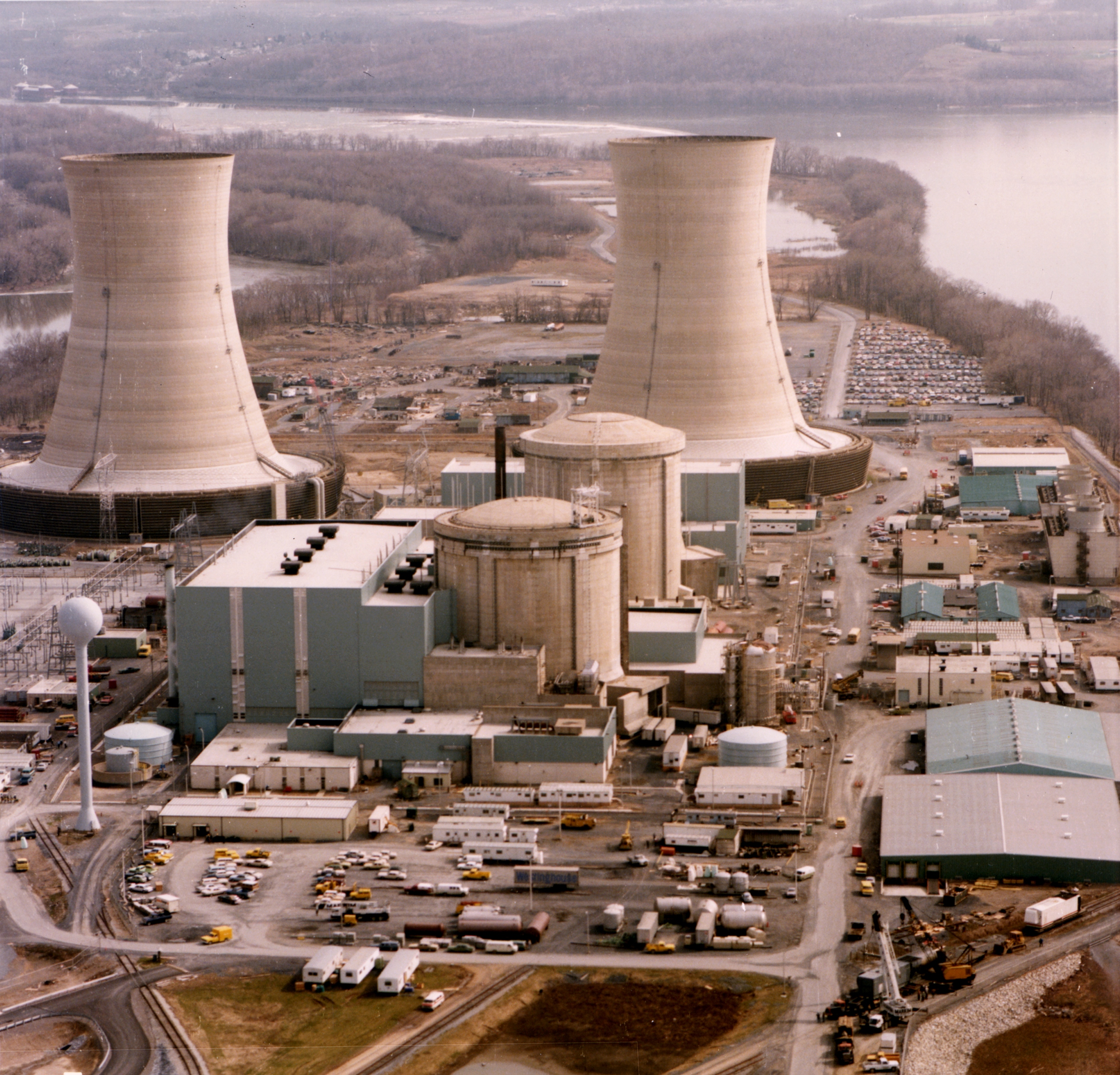
Imagem numa resolução maior (2 592 × 2 488 píxeis, tamanho: 2,62 MB, tipo MIME: image/jpeg)
|
|
Esta imagem provém do Wikimedia Commons, um acervo de conteúdo livre da Wikimedia Foundation que pode ser utilizado por outros projetos.
|
Descrição do ficheiro
| Descrição |
English: Color photograph of the Three Mile Island nuclear generating station, which suffered a partial meltdown in 1979. The reactors are in the smaller domes with rounded tops (the large smokestacks are just cooling towers).
Français : Photographie en couleurs de la centrale nucléaire de Three Mile Island, aux états-Unis, qui a subi une fusion partielle d'un de ses réacteurs, en 1979. Les réacteurs sont dans les dômes en béton. Les grandes cheminées ne sont que de tours de refroidissement. |
| Data | |
| Origem | http://ma.mbe.doe.gov/me70/history/photos.htm |
| Autor | United States Department of Energy |
| Permissão (Reutilizar este ficheiro) |
Identified on DOE page as "DOE photo", i.e. not copyrighted. |
| Outras versões |
|
-2.jpg)
.jpg)
| Localização da câmara | | Esta e outras imagens nas suas localizações em: OpenStreetMap |
|---|
.jpg¶ms=040.156606_N_-076.725812_E_globe:Earth_type:camera_region:US_heading:180.00&language=pt)

|
Esta imagem foi avaliada de acordo com os critérios para imagens de valor e foi considerada a imagem de maior valor na Commons no domínio: Three Mile Island Nuclear Generating Station. Pode consultar o processo de nomeação em Commons:Candidatas a imagem de valor/Three Mile Island (color).jpg. |
.jpg)
Licenciamento
| This image is a work of a United States Department of Energy (or predecessor organization) employee, taken or made as part of that person's official duties. As a work of the U.S. federal government, the image is in the public domain.
Please note that national laboratories operate under varying licences and some are not free. Check the site policies of any national lab before crediting it with this tag.
|

|
Histórico do ficheiro
Clique uma data e hora para ver o ficheiro tal como ele se encontrava nessa altura.
| Data e hora | Miniatura | Dimensões | Utilizador | Comentário | |
|---|---|---|---|---|---|
| atual | 09h36min de 4 de novembro de 2011 | | 2 592 × 2 488 (2,62 MB) | Yann | higher resolution, better colors |
| 15h24min de 21 de outubro de 2009 |  | 2 592 × 2 500 (2,59 MB) | Pieter Kuiper | Higher resolution from http://narademo.umiacs.umd.edu/cgi-bin/isadg/viewobject.pl?object=77214 | |
| 12h48min de 1 de agosto de 2005 |  | 678 × 532 (420 kB) | Fastfission~commonswiki | Color photograph of the Three Mile Island nuclear generating station. Source: http://ma.mbe.doe.gov/me70/history/photos.htm Copyright status: Identified on DOE page as "DOE photo", i.e. not copyrighted. {{PD-USGov-DOE}} |
Utilização local do ficheiro
As seguintes 2 páginas usam este ficheiro:
Utilização global do ficheiro
As seguintes wikis usam este ficheiro:
- cs.wikipedia.org
- de.wikipedia.org
- en.wikibooks.org
- es.wikipedia.org
- it.wikipedia.org
- ja.wikipedia.org
- ko.wikipedia.org
- ms.wikipedia.org
- sk.wikipedia.org
- sl.wikipedia.org
- th.wikipedia.org
- tr.wikipedia.org
- zh-classical.wikipedia.org
- zh.wikipedia.org
.jpg)