Ficheiro:United Kingdom United States Locator.svg

Dimensões desta antevisão em PNG do ficheiro SVG: 800 × 353 píxeis Outras resoluções: 320 × 141 píxeis | 640 × 283 píxeis | 1 024 × 452 píxeis | 1 280 × 565 píxeis | 2 560 × 1 130 píxeis | 940 × 415 píxeis.
Imagem numa resolução maior (ficheiro SVG, de 940 × 415 píxeis, tamanho: 2,56 MB)
|
|
Esta imagem provém do Wikimedia Commons, um acervo de conteúdo livre da Wikimedia Foundation que pode ser utilizado por outros projetos.
|
Descrição do ficheiro
| Descrição |
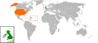
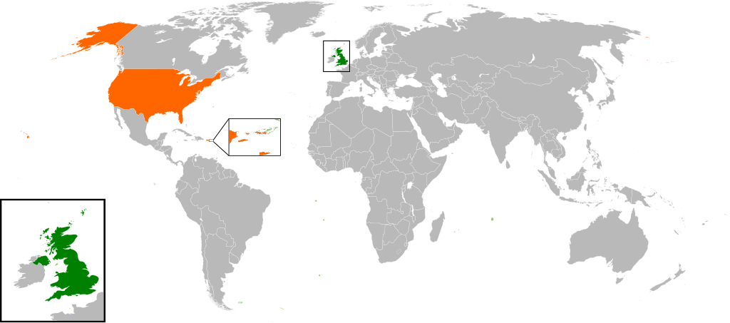
English: Map of the world showing the location of the United Kingdom and the United States of America. |
| Data | |
| Origem | Obra do próprio |
| Autor | Jolly Janner |
Licenciamento
| Eu, titular dos direitos de autor desta obra, dedico-a ao domínio público, com aplicação em todo o mundo. Nalguns países isto pode não ser legalmente possível; se assim for: Concedo a todos o direito de usar esta obra para qualquer fim, sem quaisquer condições, a menos que tais condições sejam impostas por lei. |
Histórico do ficheiro
Clique uma data e hora para ver o ficheiro tal como ele se encontrava nessa altura.
| Data e hora | Miniatura | Dimensões | Utilizador | Comentário | |
|---|---|---|---|---|---|
| atual | 16h00min de 20 de março de 2017 | | 940 × 415 (2,56 MB) | RaviC | add dependencies, inset map for Virgin Islands region where both states share a maritime border |
| 02h43min de 24 de dezembro de 2016 |  | 940 × 415 (1,79 MB) | BurritoBazooka | put all Faroe islands except Suðuroy region behind black border of UK box. Make two boxes (transparent group rectangle and white bg rectangle) same stroke thickness. | |
| 00h43min de 24 de dezembro de 2016 |  | 940 × 415 (1,79 MB) | BurritoBazooka | add France and Faroe Islands to UK box by re-cutting it from its place on the map (b/c why should ROI, another sovereign state, be shown, and not France and the Faroe Islands?) Also the box has its own group now. | |
| 00h34min de 24 de dezembro de 2016 |  | 940 × 415 (1,78 MB) | BurritoBazooka | French Polynesia, Pitcairn Islands were showing in the UK box, but these are not in the same area as the British Isles at all. Also, are Falklands etc not on the same level as Puerto Rico? | |
| 18h38min de 7 de dezembro de 2016 |  | 940 × 415 (1,78 MB) | Mikey641 | Accident | |
| 18h38min de 7 de dezembro de 2016 |  | 512 × 226 (753 kB) | Mikey641 | -- | |
| 18h09min de 3 de março de 2013 |  | 940 × 415 (1,78 MB) | Timothy Gu | +South Sudan (w/ small Britain map) | |
| 21h25min de 2 de março de 2012 |  | 940 × 415 (1,63 MB) | Jrobin08 | Reverted to version as of 20:37, 24 June 2009 (Easier to see the United Kingdom. Maybe someone can add South Sudan to the map, but keep the UK zoom box in.) | |
| 21h05min de 23 de setembro de 2011 |  | 940 × 415 (1,76 MB) | Bazonka2 | + South Sudan | |
| 20h37min de 24 de junho de 2009 |  | 940 × 415 (1,63 MB) | Jolly Janner | {{Information |Description={{en|1=Map of the world showing the location of the United Kingdom and the United States of America.}} |Source=Own work by uploader |Author=Jolly Janner |Date=2009-0 |
Utilização local do ficheiro
A seguinte página usa este ficheiro:
Utilização global do ficheiro
As seguintes wikis usam este ficheiro:
- ar.wikipedia.org
- ca.wikipedia.org
- de.wikipedia.org
- en.wikipedia.org
- es.wikipedia.org
- fr.wikipedia.org
- he.wikipedia.org
- hy.wikipedia.org
- id.wikipedia.org
- it.wikipedia.org
- ja.wikipedia.org
- ps.wikipedia.org
- ru.wikipedia.org
- th.wikipedia.org
- tr.wikipedia.org
- uk.wikipedia.org
- www.wikidata.org
- zh.wikipedia.org