Ficheiro:Yemen division 2011-10-23.svg

Dimensões desta antevisão em PNG do ficheiro SVG: 800 × 522 píxeis Outras resoluções: 320 × 209 píxeis | 640 × 418 píxeis | 1 024 × 669 píxeis | 1 280 × 836 píxeis | 2 560 × 1 671 píxeis | 1 524 × 995 píxeis.
Imagem numa resolução maior (ficheiro SVG, de 1 524 × 995 píxeis, tamanho: 1,07 MB)
|
|
Esta imagem provém do Wikimedia Commons, um acervo de conteúdo livre da Wikimedia Foundation que pode ser utilizado por outros projetos.
|
Descrição do ficheiro
| Descrição |
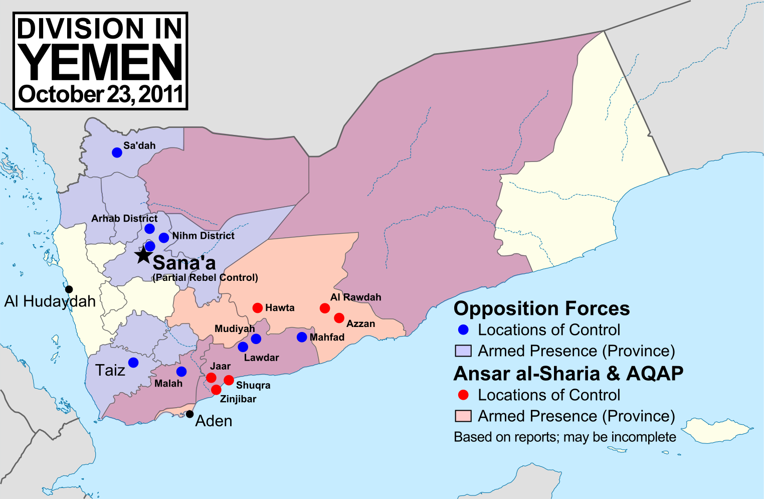
English: Note: This map depicts the situation in October 2011. For an updated version, see File:Yemen division 2012-3-11.svg. Map of division in Yemen as of October 23, 2011. Map is limited to information from English-language media, and therefore may be incomplete. Red represents Islamist extremists under Ansar al-Sharia and/or Al-Qaeda in the Arabian Peninsula (AQAP). Blue represents all other non-government armed groups which are hostile or possibly hostile to the government of President Ali Abdullah Saleh, including military defectors, pre-existing rebel groups, and local and kinship-based militias (including those which have worked together with the government against Ansar al-Sharia). Dots indicate specific locations cited by the media as being currently controlled by said groups, while shading indicates provinces (governorates) from which an open armed presence or attacks by said groups have been reported since the uprising began. Purple shading indicates that Ansar al-Sharia/AQAP and other non-government forces both have armed presences reported within the province, while white indicates that no rebel activity has been reported (implying that Saleh's government still fully maintains state power there). Note that unarmed protests are not depicted, and would extend well into the white areas of the map. See also: File:Yemen division 2011-7-7.svg |
| Data | |
| Origem | Obra do próprio, starting from File:Yemen_location_map.svg by user NordNordWest. Information comes from a variety of online news sources, especially the Yemen Post and Critical Threats. |
| Autor | GeoEvan |
| Permissão (Reutilizar este ficheiro) |
Modified version of file from Political Geography Now blog, re-licensed here to allow for commercial use. Please credit "Political Geography Now" with link to http://www.polgeonow.com. |
Licenciamento
Eu, titular dos direitos de autor desta obra, publico-a com a seguinte licença:
A utilização deste ficheiro é regulada nos termos da licença Creative Commons - Atribuição-CompartilhaIgual 3.0 Não Adaptada.
- Pode:
- partilhar – copiar, distribuir e transmitir a obra
- recombinar – criar obras derivadas
- De acordo com as seguintes condições:
- atribuição – Tem de fazer a devida atribuição da autoria, fornecer uma hiperligação para a licença e indicar se foram feitas alterações. Pode fazê-lo de qualquer forma razoável, mas não de forma a sugerir que o licenciador o apoia ou subscreve o seu uso da obra.
- partilha nos termos da mesma licença – Se remisturar, transformar ou ampliar o conteúdo, tem de distribuir as suas contribuições com a mesma licença ou uma licença compatível com a original.
Histórico do ficheiro
Clique uma data e hora para ver o ficheiro tal como ele se encontrava nessa altura.
| Data e hora | Miniatura | Dimensões | Utilizador | Comentário | |
|---|---|---|---|---|---|
| atual | 15h15min de 19 de novembro de 2011 | | 1 524 × 995 (1,07 MB) | GeoEvan | Corrections per English Wikipedia talk page (http://en.wikipedia.org/wiki/File_talk:Yemen_division_2011-10-23.svg): Added Sa'dah city to opposition controlled locations; changed "Islamist Militants" label to "Ansar a-Sharia & AQAP" so as to exclude the un |
| 19h41min de 25 de outubro de 2011 |  | 1 524 × 995 (1,04 MB) | GeoEvan | =={{int:filedesc}}== {{Information |description={{en|1=Map of division in Yemen as of October 23, 2011. Map is limited to information from from English-language media, and therefore may be incomplete. Red represents Islamist militants (Ansar al-Sharia and |
Utilização local do ficheiro
As seguintes 3 páginas usam este ficheiro:
Utilização global do ficheiro
As seguintes wikis usam este ficheiro:
- azb.wikipedia.org
- ca.wikipedia.org
- en.wikipedia.org
- hy.wikipedia.org
- it.wikipedia.org
- ka.wikipedia.org
- pl.wikipedia.org
- ru.wikipedia.org
- www.wikidata.org