Pereia
Pereia (em grego: Περαία, "o país além") foi o termo usado principalmente durante o período romano inicial para parte da antiga Transjordânia. Situava-se amplamente a leste da Judeia e Samaria, que estavam situadas no lado ocidental do rio Jordão, e a sudoeste da Decápolis.


Pereia fazia parte do reino de Herodes, o Grande e seus descendentes, e mais tarde das províncias romanas subsequentes que incluíam Iudeia.
Geografia editar
Pereia era uma faixa de terra esbelta a leste do rio Jordão. Ele se estendia de Wadi Yabis ao norte até Wadi Mujib (Nahal Arnon) no sul. A região se estendia do rio Jordão para o oeste até o sopé do leste em direção a Amã (então conhecida como Filadélfia). Josefo observa que o limite norte de Pereia era perto de Pella, enquanto a leste, fazia fronteira com os territórios de Gerasa e Filadélfia (ambos parte da Decápolis) e Heshbon. Ao sul, era adjacente à Terra de Moabe, com Machaerus marcando sua fortaleza mais ao sul.[1]
Abrangendo cerca de 2 625 quilômetros quadrados, Josefo foi preciso ao afirmar que Pereia ultrapassou a Galileia em tamanho, já que a Galileia se estendia por aproximadamente 2 200 quilômetros quadrados. Josefo descreveu Pereia principalmente como "deserto" e "acidentado", com bolsões de áreas bem cultivadas, uma característica que agora está passando por transformação devido a extensas iniciativas de irrigação.[2]
História editar
O território do que em algum momento da história ficaria conhecido como Peraea ou Pereia fazia parte da Transjordânia, que no período helenístico mudou de mãos entre os estados dos herdeiros de Alexandre, o Grande, os árabes nabateus e os judeus hasmoneus.

Pereia era a porção do reino de Herodes, o Grande, que ocupava o lado oriental do vale do rio Jordão, de um ponto cerca de um terço do caminho até o baixo rio Jordão (ou seja, o segmento que liga o Mar da Galileia com o Mar Morto), até um ponto cerca de um terço abaixo da costa oriental do Mar Morto; não se estendia muito para o leste. O reino de Herodes, o Grande, foi legado a quatro herdeiros, dos quais Herodes Antipas recebeu tanto Peréia quanto Galileia. Ele dedicou a cidade de Livias, no norte do Mar Morto, à esposa de Augusto, Julia Augusta, nascida Livia Drusilla. Em 39 d.C., Pereia e Galileia foram transferidas da desfavorecida Antipas para Agripa I por Calígula. Com sua morte em 44 d.C., o território fundido de Agripa foi transformado em província novamente, incluindo a Judeia e, pela primeira vez, Peréia. A partir dessa época Pereia fez parte das províncias romanas em mudança para o seu oeste: Judéia, e mais tarde Síria Palaestina, Palaestina e Palaestina Prima. Atestado principalmente nos livros de Josefo, o termo foi usado mais raramente no final do período romano. Aparece na obra geográfica em língua grega de Eusébio, Onomasticon, mas na tradução latina de Jerônimo, a Transjordânia é usada.[3]
Gadara/Gadora em Peraeia editar
Gadara ou Gadora de Pereia (identificada como Tell Jadur perto de Al-Salt)[4][5] foi a principal cidade ou metrópole de Pereia (uma cidade judaica, não confundir com Gadara da Decápolis - uma cidade helenística).[6][7] Após a conquista romana da Judeia liderada por Pompeu em 63 a.C., Aulo Gabínio, procônsul da Síria, dividiu o antigo reino dos Hasmoneus em cinco distritos de conselhos legais e religiosos conhecidos como sinédria (no contexto judaico mais conhecidos como sanhedrins) e baseados em Jerusalém, Jericó, Séforis (Galileia), Amathus (Pereia) e Gadara (ou em Pereia em Al-Salt, na Decápolis em Umm Qais,[8][9][10][11] ou em Gezer bíblico na Judeia, mencionado por Josefo sob uma forma helenizada de seu nome semítico, Gadara, editado para "Gazara" na edição de Loeb).[12]
Incorporação hasmoneana editar
-
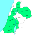
 Reino Hasmoneu estabelecido em 167-160 a.C. sob Judas Macabeu
 -
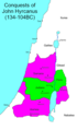
 Reino Hasmoneu em 161-143 a.C. sob Jonathan Apphus (após a conquista de Pereia
 -
 Reino Hasmoneu em 142-135 a.C. sob Simon Thassi
 -
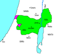
 Reino Hasmoneu em 134-104 a.C. sob João Hircano (após a conquista de Samaria e Idumea)
 -
 Reino Hasmoneu em 104-103 a.C. sob Aristóbulo I (após a conquista da Galileia))
 -
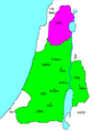
 Reino Hasmoneu em 103-76 a.C. sob Alexandre Janeu (após a conquista de Itureia)
 -
 Reino Hasmoneu em 76-67 a.C. sob Salomé Alexandra
 -
 Colapso do Reino Hasmoneu em 67-66 a.C. sob Hircano II


Incorporação herodiana editar
- O reino herodiano da Judeia
-
-
 O reino de Herodes foi dividido entre seus filhos
 -

-

-


_(1900)_(14576629399).jpg)

Incorporação posterior editar


Referências editar
- ↑ Kokkinos, Nikos (1 de janeiro de 2016), «11 An Approach to Herodian Peraea», ISBN 978-90-04-30659-2, Brill, Viewing Ancient Jewish Art and Archaeology (em inglês), pp. 271–272, doi:10.1163/9789004306592_012, consultado em 30 de janeiro de 2024
- ↑ Kokkinos, Nikos (1 de janeiro de 2016), «11 An Approach to Herodian Peraea», ISBN 978-90-04-30659-2, Brill, Viewing Ancient Jewish Art and Archaeology (em inglês), pp. 271–272, doi:10.1163/9789004306592_012, consultado em 30 de janeiro de 2024
- ↑ Two cities of Perea, Abela and Iulias (Livias), make an exception, having been kept by Agrippa II (Mason, S. Josefo) to his death c. 100 CE.
- ↑ Rocca, Samuel (2015). Herod's Judaea: A Mediterranean State in the Classic World. Col: Texts and Studies in Ancient Judaism / Texte Und Studien Zum Antiken Judentum, Volume 122 reprint of 2008 Mohr Siebeck ed. [S.l.]: Wipf and Stock. p. 188. ISBN 9781498224543. ISSN 0721-8753. Consultado em 5 de junho de 2020
- ↑ MacAdam, Henry Innes (2018). Geography, Urbanisation and Settlement Patterns in the Roman Near East. Col: Routledge Revivals. Variorum Collected Studies, CS 735 reprint of 2002 Ashgate ed. [S.l.]: Routledge. p. VI/16. ISBN 978-1-138-74056-3. Consultado em 5 de junho de 2020
- ↑ Kitto, John (1851). The Cyclopædia of Biblical Literature. [S.l.]: Newman & Ivison. p. 723.
GADARA was the chief city or metropolis of Peraea, lying in the district termed Gadaritis, some small distance from the southern extremity of the sea of Galilee, sixty stadia from Tiberias, to the south of the river Hieromax, and also of the Scheriat-al-Mandhur (Joseph. Antiq. xiii. 13. 3; Polyb. v. 71. 3; Joseph. De Bell. Jud. iv. 8. 3; Plin. Hist. Nat. v. 15). It was fortified, and stood on a hill of limestone. Its inhabitants were mostly heathens. Josephus says of it in conjunction with Gaza and Hippos 'they were Grecian cities' (Antiq. xvii. 11. 4).
- ↑ Piotrkowski, Meron M. (2011). «When Did Alexander Yannai Capture Which Gadara?». Jewish Studies Quarterly. 18 (3): 266–276. doi:10.1628/094457011797248453. Consultado em 4 de julho de 2016.
What may be concluded from these observations is that it was probably Gadara of the Peraea, not the more famous city [Gadara] of the Decapolis, that Yannai conquered early in his reign, as indicated in War 1.86 // Ant 13.356. This allows us to maintain an early dating of 102/101 BCE for the conquest of Gadara of the Peraea, alongside Amathus, while it also allows us to accept the inscription of 84 BCE as providing a terminus post quem for the conquest of the Gadara of the Decapolis.
- ↑ Predefinição:Cite Josephus: "And when he had ordained five councils (συνέδρια), he distributed the nation into the same number of parts. So these councils governed the people; the first was at Jerusalem, the second at Gadara, the third at Amathus, the fourth at Jericho, and the fifth at Sepphoris in Galilee."
- ↑ "Josephus uses συνέδριον for the first time in connection with the decree of the Roman governor of Syria, Gabinius (57 BCE), who abolished the constitution and the then existing form of government of Palestine and divided the country into five provinces, at the head of each of which a sanhedrin was placed ("Ant." xiv 5, § 4)." via Jewish Encyclopedia: Sanhedrin:
- ↑ Malamat, Abraham; Ben-Sasson, Haim Hillel (1976). A History of the Jewish People. [S.l.]: Harvard University Press. p. 262. ISBN 978-0-674-39731-6.
Jewish Trans-Jordan reached from the hellenized city Pella (Fahal) in the north to Machaerus, east of the Dead Sea, in the south. Its western border was the Jordan River, and in the east it extended until the territory of the Greek cities Gerasa and Philadelphia. The settled area of the Peraea was divided into two parts. The smaller and doubtlessly less populated area lay north of the Jabbok. Its most important settlement was Amathus, a strong fortress from the Hellenistic period that had been conquered by Alexander Jannai and had become a Jewish town of some importance, the seat of a local Sanhedrin in the days of Gabinius and the capital of a toparchy. However, the majority of the Jews in Trans-Jordan lived south of the Jabbok, across the river from north-eastern Judea. The capital of this region was Gador (Es-Salt), which was considered the capital of the entire Peraea. South of Gador lay Abila (Abel-shittim) and Beth-haramata, and still farther to the south was the fortress Machaerus. Thus, geographically, the situation of Jewish Trans-Jordan was marked by two characteristics: its nearness to and common border with Judea and its location within the generally hostile neighborhood of the Greek cities to the east and north.
- ↑ Ḳornfeld, Geʾalyahu; Mazar, Benjamin; Maier, Paul L. (1 de janeiro de 1982). Josephus, the Jewish War: Newly Translated with Extensive Commentary and Archaeological Background Illustrations. [S.l.]: Zondervan Publishing House. p. 42. ISBN 978-0-310-39210-1.
...Jewish TransJordan was represented by two councils: one in Gadara (Gedor), identified as E-tell in Peraea, near modern es-Salt in Jordan, and the other in Amathus (Hamthan), southeast of the Sea of Galilee.
- ↑ Meyers, Eric M. (1999). Meyers, Eric M., ed. Sepphoris on the Eve of the Great Revolt. Papers of the 2nd International Conference on Galilee in Antiquity, 1997, Duke University. Galilee Through the Centuries: Confluence of Cultures. Col: Duke Judaic studies, volume 1. [S.l.]: Eisenbrauns. p. 113. ISBN 9781575060408. Consultado em 30 de maio de 2020
Ligações externas editar
- Pereia no livro de fontes históricas por Mahlon H. Smith