Ficheiro:Agricultural Fields near Perdizes, Minas Gerais, Brazil.JPG

Dimensões desta antevisão: 800 × 532 píxeis. Outras resoluções: 320 × 213 píxeis | 640 × 425 píxeis | 1 024 × 681 píxeis | 1 280 × 851 píxeis | 2 560 × 1 701 píxeis | 4 288 × 2 850 píxeis.
Imagem numa resolução maior (4 288 × 2 850 píxeis, tamanho: 2,83 MB, tipo MIME: image/jpeg)
|
|
Esta imagem provém do Wikimedia Commons, um acervo de conteúdo livre da Wikimedia Foundation que pode ser utilizado por outros projetos.
|
Descrição do ficheiro
| Descrição |
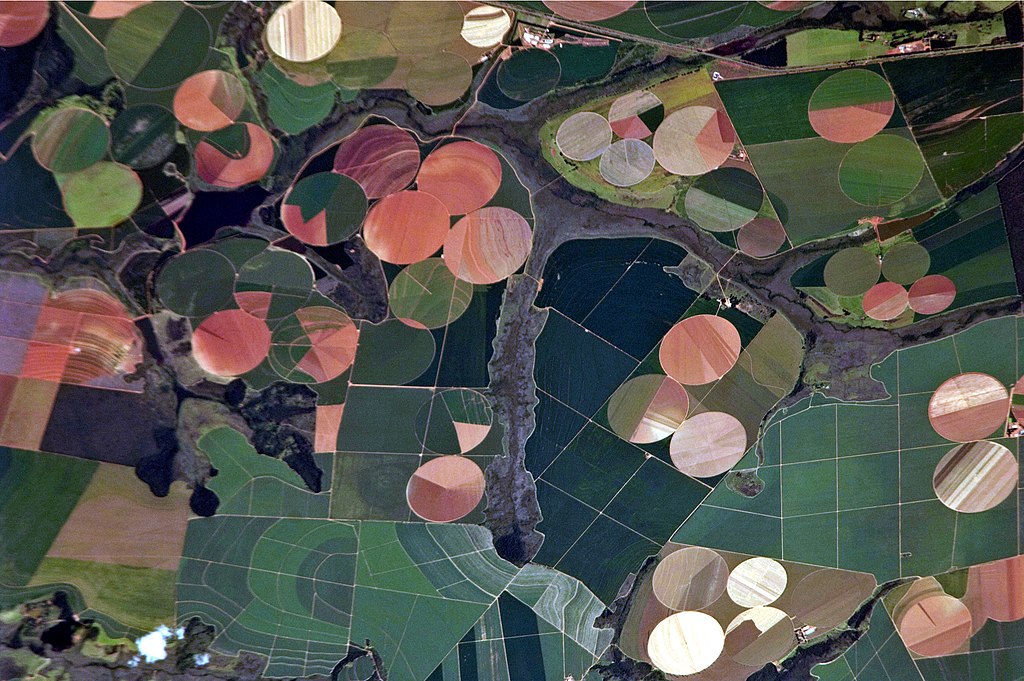
English: This astronaut photograph illustrates the diverse agricultural landscape in the western part of Minas Gerais state in Brazil. The fields in this image are located south-west of the city of Perdizes, which means “partridges” in Portuguese. A mix of regularly-gridded polygonal fields and circular centre-pivot fields marks the human use of the region. Small streams (and their adjacent floodplains) of the Araguari River extend like fingers throughout the landscape. – The visual diversity of the field forms is matched by the variety of crops: sunflowers, wheat, potatoes, coffee, rice, soybeans, and corn are among the products of the region. While the Northern Hemisphere is still in the grip of winter, crops are growing in the Southern Hemisphere, as indicated by the many green fields. Fallow fields—not in active agricultural use—display the violet, reddish, and light tan soils common to this part of Brazil. Darker soils are often rich in iron and aluminum oxides, and are typical of highly weathered soil that forms in hot, humid climates. |
| Data | |
| Origem |
English: NASA Earth Observatory – Image acquired with a Nikon D2Xs digital camera using an 800 mm lens, and is provided by the ISS Crew Earth Observations experiment and Image Science & Analysis Laboratory, Johnson Space Center. |
| Autor | ISS Expedition 26 crew |
| Localização da câmara | | Esta e outras imagens nas suas localizações em: OpenStreetMap |
|---|
Este(a) imagem ou vídeo foi catalogado(a) por Centro Espacial Johnson dos Estados Unidos da América para a Administração Nacional da Aeronáutica e do Espaço (NASA), sobre o código ID: ISS026-E-25373. Esta marcação não indica o estado dos direitos de autor da obra aqui mostrada. Continua a ser necessária uma marcação normal de direitos de autor. Veja Commons:Licenciamento para mais informações. Outras línguas:
|
Licenciamento
"The Gateway to Astronaut Photography of Earth". Esta imagem é uma cortesia do Laboratório de Ciências e Análises do Centro Espacial Johnson da NASA.
Fonte: ISS026-E-25373.
|
| Anotações | Esta imagem está anotada: Ver as anotações na wiki Commons |
Histórico do ficheiro
Clique uma data e hora para ver o ficheiro tal como ele se encontrava nessa altura.
| Data e hora | Miniatura | Dimensões | Utilizador | Comentário | |
|---|---|---|---|---|---|
| atual | 17h46min de 15 de dezembro de 2014 | | 4 288 × 2 850 (2,83 MB) | ArionStar | Reverted to version as of 12:59, 21 February 2011 |
| 14h38min de 10 de dezembro de 2014 |  | 2 629 × 1 994 (1,1 MB) | ArionStar | Lower resolution but better quality | |
| 14h30min de 10 de dezembro de 2014 |  | 2 616 × 2 028 (1,14 MB) | ArionStar | Lower resolution but better quality | |
| 12h59min de 21 de fevereiro de 2011 |  | 4 288 × 2 850 (2,83 MB) | Originalwana | {{Information |Description ={{en|1=This astronaut photograph illustrates the diverse agricultural landscape in the western part of Minas Gerais state in Brazil. The fields in this image are located south-west of the city of [[:Category:Perdizes|Perdize |
Utilização local do ficheiro
As seguintes 3 páginas usam este ficheiro:
Utilização global do ficheiro
As seguintes wikis usam este ficheiro:
- bg.wikipedia.org
- el.wikipedia.org
- en.wikipedia.org
- eu.wikipedia.org
- fr.wikipedia.org
- nl.wikipedia.org