Ficheiro:European Middle Neolithic.gif
Dimensões desta antevisão: 800 × 397 píxeis. Outras resoluções: 320 × 159 píxeis | 640 × 317 píxeis | 1 307 × 648 píxeis.
Imagem numa resolução maior (1 307 × 648 píxeis, tamanho: 101 kB, tipo MIME: image/gif)
|
|
Esta imagem provém do Wikimedia Commons, um acervo de conteúdo livre da Wikimedia Foundation que pode ser utilizado por outros projetos.
|
Descrição do ficheiro

|
File:European-middle-neolithic-en.svg é uma versão vetorial deste ficheiro. Ela deve ser usada em vez desta imagem em formato raster, se não for de qualidade inferior.
File:European Middle Neolithic.gif → File:European-middle-neolithic-en.svg
Para mais informações, consulte Ajuda:SVG. |
 |
.
| Descrição |
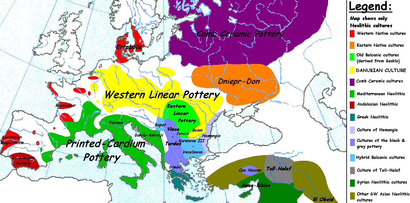
English: Map of the second half European Middle Neolithic at the apogee of Danubian and Mediterranean expansion. (The modification of the original map - Combed pottery, earlier notated as Pitted Ware, see history without respecting the color code of the legend is something that I am not fully satisfied with). |
| Data | 5 de abril de 2005 (data de carregamento original) |
| Origem | Transferido de en.wikipedia para a wiki Commons. |
| Autor | Later versions were uploaded by Clarifer at en.wikipedia. |
| Outras versões |
[]
|


_en.png)
.png)
.jpg)
Licenciamento
| Esta obra foi dedicada ao domínio público pelo autor, Sugaar em Wikipédia em inglês, com aplicação em todo o mundo. Nalguns países isto pode não ser legalmente possível; se assim for: Sugaar concede a todos o direito de usar esta obra para qualquer fim, sem quaisquer condições, a menos que tais condições sejam impostas por lei. |
Registo de carregamento original
A página de descrição original está aqui. Todos os nomes de utilizador a seguir referem-se a en.wikipedia.
- 2005-08-28 13:11 Clarifer 1320×663×8 (106148 bytes) Added the approximate area of the Comb Ceramic culture. Source: National Board of Antiquities, Finland. www.nba.fi
- 2005-04-05 20:12 Sugaar 1320×663×8 (103228 bytes) Map of the second half European Middle Neolithic at the apogee of Danubian and Mediterranean expansion (c. 4500-4000 BCE). Made by [[Sugaar]]. Free use authorized by the author.
Histórico do ficheiro
Clique uma data e hora para ver o ficheiro tal como ele se encontrava nessa altura.
| Data e hora | Miniatura | Dimensões | Utilizador | Comentário | |
|---|---|---|---|---|---|
| atual | 06h43min de 18 de abril de 2014 | | 1 307 × 648 (101 kB) | Spiridon Ion Cepleanu | Neolithic shorelines and banks, little details |
| 00h39min de 22 de março de 2010 |  | 1 307 × 648 (101 kB) | Ras67 | cropped | |
| 00h50min de 14 de fevereiro de 2007 |  | 1 320 × 663 (104 kB) | 32X | Auf eine alte Version zurückgesetzt | |
| 00h49min de 14 de fevereiro de 2007 |  | 1 320 × 663 (101 kB) | 32X | Original version by Sugaar. | |
| 11h14min de 31 de dezembro de 2005 |  | 1 320 × 663 (104 kB) | Glenn | Originally uploaded to en-wiki: Quote: "Map of the second half European Middle Neolithic at the apogee of Danubian and Mediterranean expansion (c. 4500-4000 BCE)." Upload text: "20:12, 5 April 2005 . . Sugaar . . 1320x663 (103228 bytes) (Map of the secon |
Utilização local do ficheiro
Não há nenhuma página que use este ficheiro.
Utilização global do ficheiro
As seguintes wikis usam este ficheiro:
- az.wikipedia.org
- be.wikipedia.org
- bg.wikipedia.org
- bs.wikipedia.org
- ca.wikipedia.org
- cs.wikipedia.org
- da.wikipedia.org
- da.wikibooks.org
- de.wikipedia.org
- en.wikipedia.org
- et.wikipedia.org
- fi.wikipedia.org
- fi.wikibooks.org
- gl.wikipedia.org
- he.wikipedia.org
- hi.wikipedia.org
- hr.wikipedia.org
- hu.wikipedia.org
- it.wikipedia.org
Ver mais utilizações globais deste ficheiro.