Ficheiro:Kotzebue Alaska aerial view.jpg

Dimensões desta antevisão: 800 × 600 píxeis. Outras resoluções: 320 × 240 píxeis | 640 × 480 píxeis | 1 024 × 768 píxeis | 1 280 × 960 píxeis | 1 500 × 1 125 píxeis.
Imagem numa resolução maior (1 500 × 1 125 píxeis, tamanho: 372 kB, tipo MIME: image/jpeg)
|
|
Esta imagem provém do Wikimedia Commons, um acervo de conteúdo livre da Wikimedia Foundation que pode ser utilizado por outros projetos.
|
| Descrição |
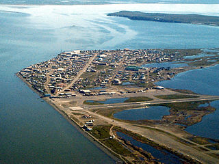
English: Aerial view of Kotzebue, Alaska, U.S. |
|||
| Local | Kotzebue, Alaska, U.S. 66°53′49.97″N 162°35′8.3″W / 66.8972139°N 162.585639°W |
|||
| Data | ||||
| Origem |
U.S. Army Corps of Engineers Digital Visual Library Image page Image description page Digital Visual Library home page |
|||
| Autor | U.S. Army Corps of Engineers, photographer not specified or unknown | |||
| Permissão (Reutilizar este ficheiro) |
|
Histórico do ficheiro
Clique uma data e hora para ver o ficheiro tal como ele se encontrava nessa altura.
| Data e hora | Miniatura | Dimensões | Utilizador | Comentário | |
|---|---|---|---|---|---|
| atual | 03h42min de 21 de março de 2007 | | 1 500 × 1 125 (372 kB) | DanMS | {{Information | Description = {{en|Aerial view of Kotzebue, Alaska, USA.}} | Source = U.S. Army Corps of Engineers Digital Visual Library<br />[http://images.usace.army.mil/images/Hires/cepoa170.jpg Image page]<br />[http://images.usace.army.mi |
Utilização local do ficheiro
As seguintes 3 páginas usam este ficheiro:
Utilização global do ficheiro
As seguintes wikis usam este ficheiro:
- ar.wikipedia.org
- azb.wikipedia.org
- az.wikipedia.org
- bg.wikipedia.org
- ca.wikipedia.org
- ceb.wikipedia.org
- ch.wikipedia.org
- de.wikipedia.org
- es.wikipedia.org
- fa.wikipedia.org
- fi.wikipedia.org
- fr.wikipedia.org
- fr.wikivoyage.org
- he.wikipedia.org
- ik.wikipedia.org
- it.wikipedia.org
- ko.wikipedia.org
- mg.wikipedia.org
- ml.wikipedia.org
- mrj.wikipedia.org
- mt.wikipedia.org
- nl.wikipedia.org
- nn.wikipedia.org
- no.wikipedia.org
- pl.wikipedia.org
- ru.wikipedia.org
- sh.wikipedia.org
- simple.wikipedia.org
- sr.wikipedia.org
- sv.wikipedia.org
- szl.wikipedia.org
- tly.wikipedia.org
- tr.wikipedia.org
- uk.wikipedia.org
- ur.wikipedia.org
- uz.wikipedia.org
- www.wikidata.org
- zh-min-nan.wikipedia.org