Ficheiro:Lake turkana satellite.jpg
Dimensões desta antevisão: 800 × 593 píxeis. Outras resoluções: 320 × 237 píxeis | 640 × 474 píxeis | 992 × 735 píxeis.
Imagem numa resolução maior (992 × 735 píxeis, tamanho: 618 kB, tipo MIME: image/jpeg)
|
|
Esta imagem provém do Wikimedia Commons, um acervo de conteúdo livre da Wikimedia Foundation que pode ser utilizado por outros projetos.
|
Descrição do ficheiro
| Descrição |
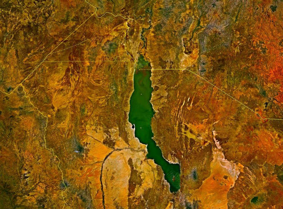
Deutsch: Satellitenbild des Turkana-Sees auf den Staatsgebieten von Kenia und Äthiopien. Die Staatsgrenzen sind als gelbe Linien eingezeichnet. Im Nordwesten befindet sich das sowohl von Äthiopien und Kenia, mindestens bis zur Unabhängigkeit des Südsudan auch vom Sudan, beanspruchte Ilemi-Dreieck.
English: Lake Turkana, Kenya and Ethiopia. satellite image. The yellow lines denote the borders. |
| Origem | NASA World Wind |
| Autor | Fotografia: NASA |
Licenciamento
| This image is in the public domain because it is a screenshot from NASA’s globe software World Wind using a public domain layer, such as Blue Marble, MODIS, Landsat, SRTM, USGS or GLOBE.
|
 |
Histórico do ficheiro
Clique uma data e hora para ver o ficheiro tal como ele se encontrava nessa altura.
| Data e hora | Miniatura | Dimensões | Utilizador | Comentário | |
|---|---|---|---|---|---|
| atual | 14h23min de 18 de agosto de 2017 | | 992 × 735 (618 kB) | Mélomène | According with [https://en.wikipedia.org/wiki/Ilemi_Triangle] |
| 00h09min de 24 de março de 2006 |  | 992 × 735 (166 kB) | Roke~commonswiki | Lake Turkana, Kenya and Ethiopia. satellite image {{PD-WorldWind}} Category: Kenya |
Utilização local do ficheiro
As seguintes 3 páginas usam este ficheiro:
Utilização global do ficheiro
As seguintes wikis usam este ficheiro:
- af.wikipedia.org
- ar.wikipedia.org
- ast.wikipedia.org
- avk.wikipedia.org
- az.wikipedia.org
- ba.wikipedia.org
- bn.wikipedia.org
- ca.wikipedia.org
- cs.wikipedia.org
- de.wikipedia.org
- en.wikipedia.org
- eo.wikipedia.org
- es.wikipedia.org
- fa.wikipedia.org
- fi.wikipedia.org
- fr.wikipedia.org
- fr.wikivoyage.org
- gl.wikipedia.org
- he.wikipedia.org
- hr.wikipedia.org
- hu.wikipedia.org
- hy.wikipedia.org
- it.wikipedia.org
- ja.wikipedia.org
- ko.wikipedia.org
- la.wikipedia.org
- lv.wikipedia.org
- nl.wikipedia.org
- nn.wikipedia.org
- no.wikipedia.org
- pl.wikipedia.org
- ro.wikipedia.org
Ver mais utilizações globais deste ficheiro.