Ficheiro:LocationBritishVirginIslands.svg

Dimensões desta antevisão em PNG do ficheiro SVG: 800 × 320 píxeis Outras resoluções: 320 × 128 píxeis | 640 × 256 píxeis | 1 024 × 410 píxeis | 1 280 × 512 píxeis | 2 560 × 1 024 píxeis | 1 750 × 700 píxeis.
Imagem numa resolução maior (ficheiro SVG, de 1 750 × 700 píxeis, tamanho: 324 kB)
|
|
Esta imagem provém do Wikimedia Commons, um acervo de conteúdo livre da Wikimedia Foundation que pode ser utilizado por outros projetos.
|

|
Uma versão bitmap desta imagem está disponível. Deve ser usada no lugar deste desenho vetorial se for mais apropriado. File:LocationBritishVirginIslands.svg → File:LocationBritishVirginIslands.png
Para mais informações sobre gráficos vetoriais, leia sobre Ajuda:SVG. |
Descrição do ficheiro
| Descrição |
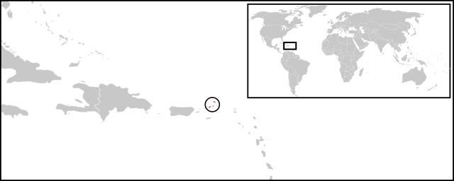
English: Location map for British Virgin Islands. Vectorised version of Image:LocationBritishVirginIslands.png |
| Data | (UTC) |
| Origem |
Este(a) desenho vetorial não especificado foi criado com o Inkscape . |
| Autor |
|
Licenciamento
| Esta é uma imagem retocada, o que significa que a versão original foi alterada digitalmente. Modificações: Combined two maps to form a newly vectorised version of the British Virgin Islands map. O original pode ser visto aqui: BlankMap-Caribbean.svg:
|
| Eu, titular dos direitos de autor desta obra, dedico-a ao domínio público, com aplicação em todo o mundo. Nalguns países isto pode não ser legalmente possível; se assim for: Concedo a todos o direito de usar esta obra para qualquer fim, sem quaisquer condições, a menos que tais condições sejam impostas por lei. |
Registo de carregamento original
This image is a derivative work of the following images:
- File:BlankMap-World-v2.svg licensed with PD-self
- 2011-03-27T23:08:42Z Wayiran 1243x564 (209452 Bytes) Some correction on North-west border of Iran's map + south of Caspian sea
- 2008-12-03T18:02:36Z Harbin 1326x601 (192122 Bytes)
- 2008-12-02T19:55:14Z Harbin 1326x601 (197882 Bytes)
- 2008-12-02T19:04:59Z Harbin 1326x601 (176022 Bytes) {{Information |Description={{en|1=A blank map of the world as of 2005, with country outlines. Sovereign microstates less than 2 500 km² in area are depicted as circles (see Wikipedia:Image_talk:BlankMap-World-v2.png for list
- File:BlankMap-Caribbean.svg licensed with PD-self
- 2010-09-20T02:01:50Z NuclearVacuum 896x633 (274735 Bytes) new version
- 2010-02-23T15:29:09Z NuclearVacuum 2201x1507 (214283 Bytes) cleanup
- 2010-02-11T19:26:10Z NuclearVacuum 2201x1507 (211807 Bytes) I have started from scratch and made a completely new map of the Caribbean. This current version has an invalid code, but I will work on that later.
- 2009-09-22T00:08:34Z NuclearVacuum 940x477 (252618 Bytes) {{Information |Description={{en|1=Map of the [[:en:Caribbean|Caribbean nations]].}} |Source=[[:File:BlankMap-World6.svg]]{{Inkscape}} |Author=[[User:NuclearVacuum|NuclearVacuum]] |Date=2009-09-21 |Permission= |other_versions=
Carregada com derivativeFX
Histórico do ficheiro
Clique uma data e hora para ver o ficheiro tal como ele se encontrava nessa altura.
| Data e hora | Miniatura | Dimensões | Utilizador | Comentário | |
|---|---|---|---|---|---|
| atual | 02h08min de 30 de junho de 2011 | 1 750 × 700 (324 kB) | Maky | {{Bitmap version available|LocationBritishVirginIslands.png}} {{Information |Description={{en|1=Location map for British Virgin Islands.<br> Vectorised version of Image:LocationBritishVirginIslands.png}} |Source=*File:BlankMap-World-v2.svg |
Utilização local do ficheiro
Não há nenhuma página que use este ficheiro.
Utilização global do ficheiro
As seguintes wikis usam este ficheiro:
- ceb.wikipedia.org
- el.wikipedia.org
- en.wikipedia.org
- es.wikinews.org
- eu.wikipedia.org
- fr.wikipedia.org
- fr.wiktionary.org
- gcr.wikipedia.org
- ko.wikipedia.org
- mk.wikipedia.org
- pnb.wikipedia.org
- ro.wikipedia.org
- su.wikipedia.org
- sv.wikipedia.org
- vi.wikipedia.org
- www.wikidata.org