Ficheiro:Map of Lycoming County Pennsylvania With Municipal and Township Labels.png

Dimensões desta antevisão: 800 × 495 píxeis. Outras resoluções: 320 × 198 píxeis | 640 × 396 píxeis | 882 × 546 píxeis.
Imagem numa resolução maior (882 × 546 píxeis, tamanho: 62 kB, tipo MIME: image/png)
|
|
Esta imagem provém do Wikimedia Commons, um acervo de conteúdo livre da Wikimedia Foundation que pode ser utilizado por outros projetos.
|
| Descrição |
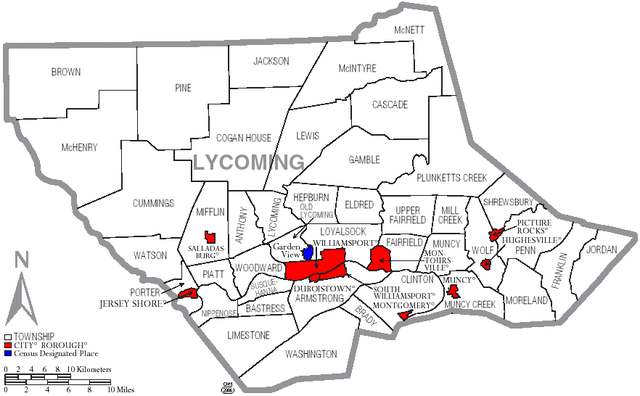
English: Map of Lycoming County with township and municipal bondaries is taken from US Census website [1] and modified by User:Ruhrfisch in August 2005. My modifications licensed under the GNU Free Documentation License. |
| Data | |
| Origem | US Census website [2] |
| Autor | Ruhrfisch |

|
É concedida permissão para copiar, distribuir e/ou modificar este documento nos termos da Licença de Documentação Livre GNU, versão 1.2 ou qualquer versão posterior publicada pela Free Software Foundation; sem Secções Invariantes, sem textos de Capa e sem textos de Contra-Capa. É incluída uma cópia da licença na secção intitulada GNU Free Documentation License. |
| A utilização deste ficheiro é regulada nos termos da licença Creative Commons - Atribuição-CompartilhaIgual 3.0 Não Adaptada. | ||
| ||
| Esta marca de licenciamento foi adicionada a este ficheiro durante a atualização da licença GFDL. |
Histórico do ficheiro
Clique uma data e hora para ver o ficheiro tal como ele se encontrava nessa altura.
| Data e hora | Miniatura | Dimensões | Utilizador | Comentário | |
|---|---|---|---|---|---|
| atual | 18h03min de 16 de junho de 2006 | | 882 × 546 (62 kB) | Ruhrfisch | {{Information |Description=Map of Lycoming County with township and municipal bondaries |Source=taken from US Census website [http://factfinder.census.gov/] and modified by User:Ruhrfisch |Date=June 2006 |Author= US Census / Government and Ruhrfisch |
| 18h41min de 3 de abril de 2006 |  | 882 × 546 (62 kB) | Ruhrfisch | Map of Lycoming County with township and municipal boundaries is taken from US Census website [http://www2.census.gov/geo/maps/general_ref/cousub_outline/cen2k_pgsz/pa_cosub.pdf] and modified by User:Ruhrfisch in April 2006. My modifications licensed | |
| 19h21min de 2 de setembro de 2005 |  | 981 × 599 (25 kB) | Ruhrfisch | Map of Lycoming County with township and municipal bondaries is taken from US Census website [http://factfinder.census.gov/] and modified by User:Ruhrfisch in August 2005. My modifications licensed under the GNU Free Documentation License. Sourc |
Utilização local do ficheiro
A seguinte página usa este ficheiro:
Utilização global do ficheiro
As seguintes wikis usam este ficheiro:
- de.wikipedia.org
- en.wikipedia.org
- Lycoming County, Pennsylvania
- User talk:Cedrus-Libani
- User:Ruhrfisch/Frog
- User:Ruhrfisch/Maps
- History of Lycoming County, Pennsylvania
- List of municipalities in Lycoming County, Pennsylvania
- User talk:SatyrTN/Archive 8
- List of villages in Lycoming County, Pennsylvania
- User talk:Circeus/november2007
- User talk:Cirt/Archive 1
- User talk:Golbez/Archive 3
- ja.wikipedia.org
- nl.wikipedia.org