Ficheiro:Mexico cartel map May 2010.svg

Dimensões desta antevisão em PNG do ficheiro SVG: 800 × 544 píxeis Outras resoluções: 320 × 218 píxeis | 640 × 435 píxeis | 1 024 × 696 píxeis | 1 280 × 870 píxeis | 2 560 × 1 741 píxeis | 1 000 × 680 píxeis.
Imagem numa resolução maior (ficheiro SVG, de 1 000 × 680 píxeis, tamanho: 193 kB)
|
|
Esta imagem provém do Wikimedia Commons, um acervo de conteúdo livre da Wikimedia Foundation que pode ser utilizado por outros projetos.
|
| Descrição |
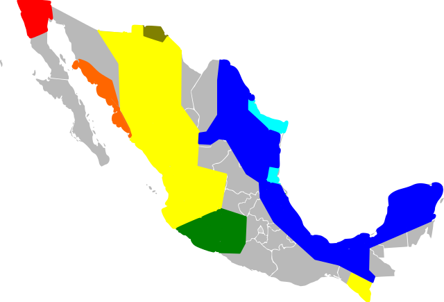
English: An approximate map of the areas held by various Mexican cartels. This map was generated using the information at [1], based on [2] (STRATFOR report dated May 17, 2010). Some points from that map were roughly located and used to draw line segments, from which the territories were filled. Note that the method of simply sampling individual location datapoints from a map precludes all possibility of copyright, and my experience trying to control Inkscape was so poor I feel like I couldn't violate copyright with it if I wanted to! Red = Tijuana/Arellano Felix, Orange = Beltran Leyva, Yellow=Sinaloa, Green=La Familia/Michoacan, Brown=Carillo Fuentes, Cyan=Gulf Cartel/New Federation, Blue=Zetas. Note that this data was likely never very reliable, has been further degraded by my method of redrawing the map, and is surely out of date as of the time I uploaded it. Last but not least, be warned this Inkscape monstrosity may not act like proper svg and could end up not displaying the way it did on my screen. |
| Data | (UTC) |
| Origem | |
| Autor |
|
![[1]](http://www.wickenburg-az.com/wp-content/uploads/2010/11/Smuggling_1-4.jpg)
Eu, titular dos direitos de autor desta obra, publico-a com as seguintes licenças:
A utilização deste ficheiro é regulada nos termos da licença Creative Commons - Atribuição-CompartilhaIgual 3.0 Não Adaptada.
- Pode:
- partilhar – copiar, distribuir e transmitir a obra
- recombinar – criar obras derivadas
- De acordo com as seguintes condições:
- atribuição – Tem de fazer a devida atribuição da autoria, fornecer uma hiperligação para a licença e indicar se foram feitas alterações. Pode fazê-lo de qualquer forma razoável, mas não de forma a sugerir que o licenciador o apoia ou subscreve o seu uso da obra.
- partilha nos termos da mesma licença – Se remisturar, transformar ou ampliar o conteúdo, tem de distribuir as suas contribuições com a mesma licença ou uma licença compatível com a original.

|
É concedida permissão para copiar, distribuir e/ou modificar este documento nos termos da Licença de Documentação Livre GNU, versão 1.2 ou qualquer versão posterior publicada pela Free Software Foundation; sem Secções Invariantes, sem textos de Capa e sem textos de Contra-Capa. É incluída uma cópia da licença na secção intitulada GNU Free Documentation License. |
Pode escolher a licença que quiser.
Registo de carregamento original
This image is a derivative work of the following images:
- File:Mexico_Map.svg licensed with Cc-by-sa-3.0, GFDL
- 2009-04-27T09:22:54Z Allstrak 1000x680 (151067 Bytes) {{Information |Description={{en|1=a gray map of the states of Mexico to use as template for other Maps}} {{nl|1=een grijze kaart van de staten van Mexico om te gebruiken als 'template' om ander kaarten op te bazeren}} |Source
Carregada com derivativeFX
Histórico do ficheiro
Clique uma data e hora para ver o ficheiro tal como ele se encontrava nessa altura.
| Data e hora | Miniatura | Dimensões | Utilizador | Comentário | |
|---|---|---|---|---|---|
| atual | 09h03min de 21 de março de 2011 | | 1 000 × 680 (193 kB) | Wnt | {{Information |Description={{en|1=An approximate map of the areas held by various Mexican cartels. This map was generated using the information at [http://www.wickenburg-az.com/wp-content/uploads/2010/11/Smuggling_1-4.jpg], based on [http://www.stratfor. |
Utilização local do ficheiro
Não há nenhuma página que use este ficheiro.
Utilização global do ficheiro
As seguintes wikis usam este ficheiro:
- af.wikipedia.org
- ast.wikipedia.org
- cs.wikipedia.org
- en.wikipedia.org
- es.wikipedia.org
- eu.wikipedia.org
- hy.wikipedia.org
- it.wikipedia.org
- ja.wikipedia.org
- ka.wikipedia.org
- ko.wikipedia.org
- pl.wikipedia.org
- ro.wikipedia.org
- ru.wikipedia.org
- ru.wikinews.org
- sk.wikipedia.org
- sr.wikipedia.org
- tr.wikipedia.org
- uk.wikipedia.org