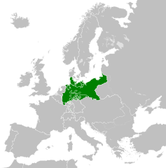
Ficheiro:North German Confederation 1870.svg

Dimensões desta antevisão em PNG do ficheiro SVG: 450 × 456 píxeis Outras resoluções: 237 × 240 píxeis | 474 × 480 píxeis | 758 × 768 píxeis | 1 011 × 1 024 píxeis | 2 021 × 2 048 píxeis.
Imagem numa resolução maior (ficheiro SVG, de 450 × 456 píxeis, tamanho: 705 kB)
|
|
Esta imagem provém do Wikimedia Commons, um acervo de conteúdo livre da Wikimedia Foundation que pode ser utilizado por outros projetos.
|
Descrição do ficheiro
Este(a) desenho vetorial não especificado foi criado com o Inkscape .


.svg)
.svg)
.svg)
.svg)
.svg)


.svg)
.svg)
.svg)


.png)
.png)


.svg)


.svg)

.svg)


.svg)
.svg)
.svg)
.svg)


.svg)
.png)


.svg)


.svg)
.svg)


.svg)


.svg)


.svg)
.svg)
.svg)
.svg)
.svg)
.svg)
.svg)
_cropped.svg)
.svg)
.svg)
.svg)
.svg)
.svg)
.svg)
.svg)
.svg)
.svg)
.svg)
.svg)
.svg)
.svg)
.svg)
.svg)
.svg)
.svg)
.svg)
.svg)
.svg)
.svg)
.svg)
.svg)
.svg)
.svg)
.svg)
.svg)
.svg)
.svg)
.svg)
.svg)
.svg)
.svg)
.svg)
.svg)
.svg)
.svg)
.svg)
.svg)
.svg)
.svg)
.svg)
.svg)
.svg)
.svg)
Licenciamento
A utilização deste ficheiro é regulada nos termos da licença Creative Commons Atribuição-CompartilhaIgual 4.0 Internacional.
- Pode:
- partilhar – copiar, distribuir e transmitir a obra
- recombinar – criar obras derivadas
- De acordo com as seguintes condições:
- atribuição – Tem de fazer a devida atribuição da autoria, fornecer uma hiperligação para a licença e indicar se foram feitas alterações. Pode fazê-lo de qualquer forma razoável, mas não de forma a sugerir que o licenciador o apoia ou subscreve o seu uso da obra.
- partilha nos termos da mesma licença – Se remisturar, transformar ou ampliar o conteúdo, tem de distribuir as suas contribuições com a mesma licença ou uma licença compatível com a original.
Histórico do ficheiro
Clique uma data e hora para ver o ficheiro tal como ele se encontrava nessa altura.
| Data e hora | Miniatura | Dimensões | Utilizador | Comentário | |
|---|---|---|---|---|---|
| atual | 02h58min de 1 de junho de 2016 | | 450 × 456 (705 kB) | Alphathon | Various corrections to the states of the North German Confederation |
| 05h22min de 31 de maio de 2016 |  | 450 × 456 (662 kB) | Alphathon | Uploaded wrong file | |
| 05h22min de 31 de maio de 2016 |  | 450 × 456 (725 kB) | Alphathon | Minor corrections (Tarasp and post-1818 German Confederation border change) | |
| 02h40min de 31 de maio de 2016 |  | 450 × 456 (662 kB) | Alphathon | == {{int:filedesc}} == {{Inkscape}} {{Information |Description={{en|A map of the en:North German Confederation within Europe circa 1870 CE.}} |Source= {{Derived from|Blank_map_of_Europe.svg|display=50}} |Date=2016-05-31 |Author=*[[:File:Bla... |
Utilização local do ficheiro
A seguinte página usa este ficheiro:
Utilização global do ficheiro
As seguintes wikis usam este ficheiro:
- ang.wikipedia.org
- ar.wikipedia.org
- azb.wikipedia.org
- bg.wikipedia.org
- cs.wikipedia.org
- en.wikipedia.org
- es.wikipedia.org
- eu.wikipedia.org
- fa.wikipedia.org
- fi.wikipedia.org
- fr.wikipedia.org
- he.wikipedia.org
- hr.wikipedia.org
- is.wikipedia.org
- it.wikipedia.org
- ko.wikipedia.org
- lt.wikipedia.org
- lv.wikipedia.org
- ms.wikipedia.org
- pl.wikipedia.org
- ru.wikipedia.org
- sv.wikipedia.org
- th.wikipedia.org
- tr.wikipedia.org
- vi.wikipedia.org
- zh.wikipedia.org