Ficheiro:Okavango Delta map.png

Imagem numa resolução maior (1 860 × 1 916 píxeis, tamanho: 733 kB, tipo MIME: image/png)
|
|
Esta imagem provém do Wikimedia Commons, um acervo de conteúdo livre da Wikimedia Foundation que pode ser utilizado por outros projetos.
|
| Descrição |
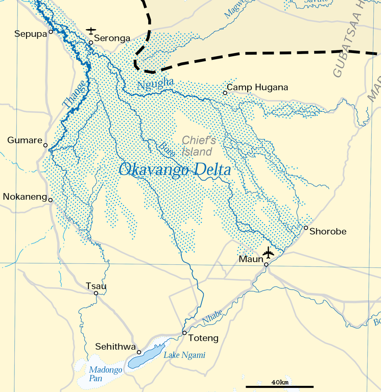
Deutsch: Karte des Okawangodeltas (vergrößerter Ausschnitt aus Datei Okavango River Basin map.png). Detaillierte Kartenlegende siehe dort.
English: Map of the Okavango delta (Botswana), expanded part of File:Okavango River Basin map.png. For detailled map legend see there.
|
| Data | |
| Origem | http://www.un.org/Depts/Cartographic/map/profile/okavango.pdf (part) |
| Autor | United Nations |
| Permissão (Reutilizar este ficheiro) |
UN map as PD |
| Outras versões |
 |
| This image is a map derived from a United Nations map.
Unless stated otherwise, UN maps are to be considered in the public domain. This applies worldwide. UN maps are, in principle, open source material and you can use them in your work or for making your own map. UN requests however that you delete the UN name, logo and reference number upon any modification to the map. Content of your map will be your responsibility. You can state in your publication, if you wish, something like: based on UN map … (map name, map number, revision number and date). See: Geospatial Information Section. And: Geospatial, location data for a better world. |
 |
Histórico do ficheiro
Clique uma data e hora para ver o ficheiro tal como ele se encontrava nessa altura.
| Data e hora | Miniatura | Dimensões | Utilizador | Comentário | |
|---|---|---|---|---|---|
| atual | 17h54min de 27 de junho de 2018 | | 1 860 × 1 916 (733 kB) | Antonsusi | adding a scale |
| 06h45min de 5 de abril de 2016 |  | 1 860 × 1 916 (427 kB) | RokerHRO | optipng -zc1-9 -zm1-9 -zs0-3 -f0-5 -i0 → 41.70% decrease | |
| 12h55min de 17 de março de 2012 |  | 1 860 × 1 916 (733 kB) | Antonsusi | {{UN map}} |
Utilização local do ficheiro
A seguinte página usa este ficheiro:
Utilização global do ficheiro
As seguintes wikis usam este ficheiro:
- af.wikipedia.org
- ar.wikipedia.org
- avk.wikipedia.org
- az.wikipedia.org
- bh.wikipedia.org
- bn.wikipedia.org
- ca.wikipedia.org
- da.wikipedia.org
- de.wikipedia.org
- en.wikipedia.org
- eo.wikipedia.org
- es.wikipedia.org
- et.wikipedia.org
- fi.wikipedia.org
- fr.wikipedia.org
- hr.wikipedia.org
- incubator.wikimedia.org
- ka.wikipedia.org
- ml.wikipedia.org
- mt.wikipedia.org
- nl.wikipedia.org
- pl.wikipedia.org
- ru.wikipedia.org
- sh.wikipedia.org
- sk.wikipedia.org
- sl.wikipedia.org
- sv.wikipedia.org
- ta.wikipedia.org
- tr.wikipedia.org
- uk.wikipedia.org
- vi.wikipedia.org
- xmf.wikipedia.org
- zh.wikipedia.org