Ficheiro:Saxony locator map (1000).svg

Dimensões desta antevisão em PNG do ficheiro SVG: 686 × 600 píxeis Outras resoluções: 275 × 240 píxeis | 549 × 480 píxeis | 878 × 768 píxeis | 1 171 × 1 024 píxeis | 2 342 × 2 048 píxeis | 4 431 × 3 875 píxeis.
Imagem numa resolução maior (ficheiro SVG, de 4 431 × 3 875 píxeis, tamanho: 4,7 MB)
|
|
Esta imagem provém do Wikimedia Commons, um acervo de conteúdo livre da Wikimedia Foundation que pode ser utilizado por outros projetos.
|
Descrição do ficheiro
Este(a) desenho vetorial não especificado foi criado com o Inkscape .
| Descrição |
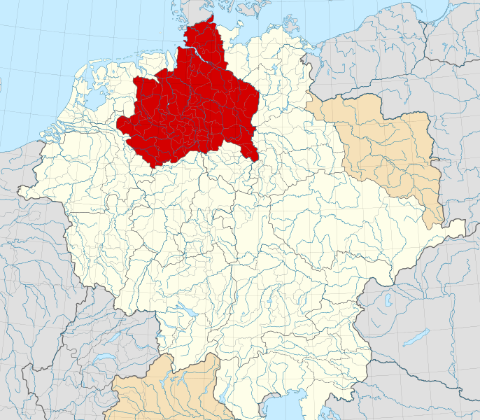
English: A map of the Duchy of Saxony (German: Herzogtum Sachsen) around 1000 CE.
The map is derived from a vectorised version of one found in Professor G. Droysens Allgemeiner Historischer Handatlas, which was published in 1886 by R. Andrée Plate, and is now in the public domain. Note that while it uses the same scheme as standard location/locator maps, this map technically does not conform to the standard, as it is not in equirectangular projection. Therefore grid lines for latitude and longitude are also included on the sub-map. |
| Data | |
| Origem |
File: own work Data: File:Droysens-22-23.jpg |
| Autor | Alphathon /ˈæɫfə.θɒn/ (talk) |
| Outras versões |
|
.svg)
.svg)
.svg)
.svg)

.svg)
.svg)
.svg)
Licenciamento
A utilização deste ficheiro é regulada nos termos da licença Creative Commons Atribuição-CompartilhaIgual 4.0 Internacional.
- Pode:
- partilhar – copiar, distribuir e transmitir a obra
- recombinar – criar obras derivadas
- De acordo com as seguintes condições:
- atribuição – Tem de fazer a devida atribuição da autoria, fornecer uma hiperligação para a licença e indicar se foram feitas alterações. Pode fazê-lo de qualquer forma razoável, mas não de forma a sugerir que o licenciador o apoia ou subscreve o seu uso da obra.
- partilha nos termos da mesma licença – Se remisturar, transformar ou ampliar o conteúdo, tem de distribuir as suas contribuições com a mesma licença ou uma licença compatível com a original.
Histórico do ficheiro
Clique uma data e hora para ver o ficheiro tal como ele se encontrava nessa altura.
| Data e hora | Miniatura | Dimensões | Utilizador | Comentário | |
|---|---|---|---|---|---|
| atual | 16h15min de 22 de maio de 2016 | | 4 431 × 3 875 (4,7 MB) | Alphathon | Changed colour of the Kingdom of Italy to reflect its inclusion in the Holy Roman Empire. Changed the colour of Silesian tributaries so as the not imply it was part of the Kingdom. Also changed colour of Rügen since it was neither in the Empire nor th... |
| 02h26min de 18 de maio de 2016 |  | 4 431 × 3 875 (4,7 MB) | Alphathon | == {{int:filedesc}} == {{Inkscape}} {{Information |Description={{en|A map of the en:Duchy of Saxony (German: ''Herzogtum Sachsen'') around 1000 CE. The map is derived from a vectorised version of one found in Professor G. Droysens Allgem... |
Utilização local do ficheiro
Não há nenhuma página que use este ficheiro.
Utilização global do ficheiro
As seguintes wikis usam este ficheiro:
- ar.wikipedia.org
- ast.wikipedia.org
- azb.wikipedia.org
- be.wikipedia.org
- bg.wikipedia.org
- ca.wikipedia.org
- cs.wikipedia.org
- de.wikipedia.org
- el.wikipedia.org
- en.wikipedia.org
- es.wikipedia.org
- et.wikipedia.org
- fa.wikipedia.org
- fr.wikipedia.org
- fy.wikipedia.org
- ga.wikipedia.org
- it.wikipedia.org
- ja.wikipedia.org
- ko.wikipedia.org
- mk.wikipedia.org
- pl.wikipedia.org
- pl.wiktionary.org
- th.wikipedia.org
- tr.wikipedia.org
- vi.wikipedia.org
- www.wikidata.org
- zh.wikipedia.org
.svg)