Ficheiro:Senyavin island (FSM).jpg

Sem resolução maior disponível.
Senyavin_island_(FSM).jpg (457 × 265 píxeis, tamanho: 102 kB, tipo MIME: image/jpeg)
|
|
Esta imagem provém do Wikimedia Commons, um acervo de conteúdo livre da Wikimedia Foundation que pode ser utilizado por outros projetos.
|
.jpg)
Descrição do ficheiro
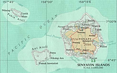
| Descrição | Map of Pohnpei (FSM - Micronesia) |
| Origem |
|
| Autor |
Licenciamento
This map was obtained from an edition of the National Atlas of the United States. Like almost all works of the U.S. federal government, works from the National Atlas are in the public domain in the United States.
Online access: NationalAtlas.gov | 1970 print edition: Library of Congress, Perry-Castañeda Library
|
Registo de carregamento original
(All user names refer to en.wikipedia)
- 2003-08-12 21:46 Pascal 457×265×8 (104132 bytes) Map of Pohnpei (FSM - Micronesia) from http://www.lib.utexas.edu/maps/australia/senyavin_island.jpg
Histórico do ficheiro
Clique uma data e hora para ver o ficheiro tal como ele se encontrava nessa altura.
| Data e hora | Miniatura | Dimensões | Utilizador | Comentário | |
|---|---|---|---|---|---|
| atual | 20h51min de 7 de março de 2007 | | 457 × 265 (102 kB) | Nicke L | {{Information |Description=Map of Pohnpei (FSM - Micronesia) |Source= *from http://www.lib.utexas.edu/maps/australia/senyavin_island.jpg *Originally from [http://en.wikipedia.org en.wikipedia]; description page is/was [http://en.wikipedia.org/w/index.php |
Utilização local do ficheiro
As seguintes 4 páginas usam este ficheiro:
Utilização global do ficheiro
As seguintes wikis usam este ficheiro:
- ca.wikipedia.org
- ceb.wikipedia.org
- de.wikipedia.org
- en.wikipedia.org
- eo.wikipedia.org
- es.wikipedia.org
- fa.wikipedia.org
- fr.wikipedia.org
- gl.wikipedia.org
- it.wikipedia.org
- ja.wikipedia.org
- ka.wikipedia.org
- lt.wikipedia.org
- lv.wikipedia.org
- mk.wikipedia.org
- nl.wikipedia.org
- no.wikipedia.org
- pl.wikipedia.org
- ru.wikipedia.org
- tl.wikipedia.org
- uk.wikipedia.org
- vi.wikipedia.org
- www.wikidata.org
- zh-min-nan.wikipedia.org
- zh.wikipedia.org
.jpg)