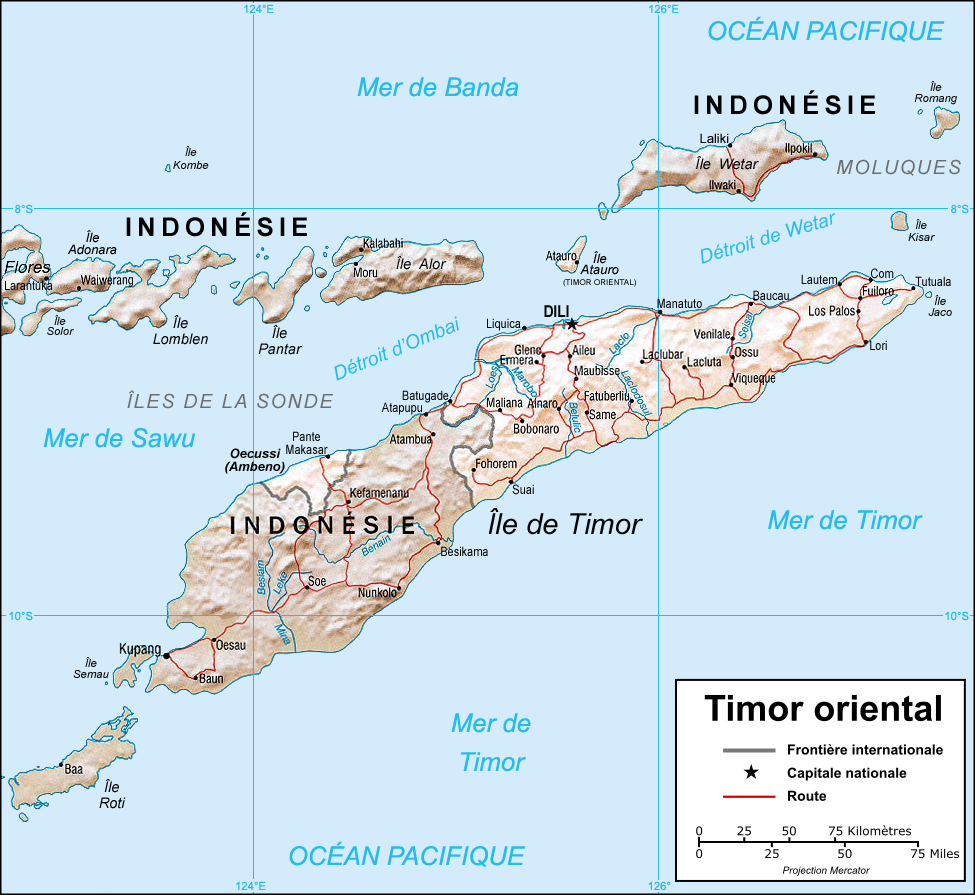
Ficheiro:Timor oriental carte.png
Dimensões desta antevisão: 653 × 599 píxeis. Outras resoluções: 261 × 240 píxeis | 523 × 480 píxeis | 975 × 895 píxeis.
Imagem numa resolução maior (975 × 895 píxeis, tamanho: 466 kB, tipo MIME: image/png)
|
|
Esta imagem provém do Wikimedia Commons, um acervo de conteúdo livre da Wikimedia Foundation que pode ser utilizado por outros projetos.
|
Descrição do ficheiro
| Descrição | Map in French of East Timor. |
| Data | |
| Origem |
Perry-Castañeda Library (PCL) of the University of Texas at Austin (cleaned and translated). |
| Autor | Eric Gaba (Sting) |
| Permissão (Reutilizar este ficheiro) |
Public domain, courtesy of the University of Texas Libraries, The University of Texas at Austin. |
| Outras versões | Original English version : Image:CIA-TimorLeste.jpg (without shaded relief). |
Français : * Sujet : Carte en français du Timor oriental ;
- Source : Perry-Castañeda Library (PCL) de l'Université du Texas à Austin (nettoyée et traduite) ;
- Avec l'aimable autorisation de l'University of Texas Libraries, The University of Texas at Austin ;
- Autres versions : Originale anglophone : Image:CIA-TimorLeste.jpg (sans relief) ;
- Auteur : Eric Gaba (fr:Sting) ;
- Date : Septembre 2006.
Licenciamento
| This work was previously under Public Domain, or a Free License. It has been digitally enhanced and/or modified. This derivative work has been (or is hereby) released into the public domain by its author, Sting at the French Wikipedia project. This applies worldwide. In some countries this is not legally possible; if so:
|
Histórico do ficheiro
Clique uma data e hora para ver o ficheiro tal como ele se encontrava nessa altura.
| Data e hora | Miniatura | Dimensões | Utilizador | Comentário | |
|---|---|---|---|---|---|
| atual | 06h28min de 1 de setembro de 2006 | | 975 × 895 (466 kB) | Sting | {{Information |Description=Map in French of East Timor. |Source=[http://www.lib.utexas.edu/maps/east_timor.html Perry-Castañeda Library] (PCL) of the [http://www.utexas.edu University of Texas at Austin] (cleaned and translated). |Date=August 2006 |Autho |
Utilização local do ficheiro
A seguinte página usa este ficheiro:
Utilização global do ficheiro
As seguintes wikis usam este ficheiro:
- fr.wikipedia.org
- fr.wikinews.org
- la.wikipedia.org
- uk.wikipedia.org