Ficheiro:Tornado Alley.gif
Sem resolução maior disponível.
Tornado_Alley.gif (742 × 582 píxeis, tamanho: 97 kB, tipo MIME: image/gif)
|
|
Esta imagem provém do Wikimedia Commons, um acervo de conteúdo livre da Wikimedia Foundation que pode ser utilizado por outros projetos.
|

|
File:Tornado Alley.svg é uma versão vetorial deste ficheiro. Ela deve ser usada em vez desta imagem em formato raster, se não for de qualidade inferior.
File:Tornado Alley.gif → File:Tornado Alley.svg
Para mais informações, consulte Ajuda:SVG. |
 |
Descrição do ficheiro
| Descrição |
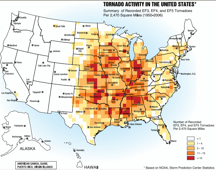
English: A map of the frequency of F3 and greater intensity tornadoes by area. The darker colors highlight the areas typically known as a Tornado Alley. |
| Data | |
| Origem | Image from Federal Emergency Management Agency, a United States government agency, booklet FEMA 320 Third Edition, Section 1, Figure 1.1, page 3, titled Taking Shelter from the Storm: Building a Safe Room Inside your House |
| Autor | FEMA personnel |
Licenciamento
This image is a work of a Federal Emergency Management Agency employee, taken or made as part of that person's official duties. As works of the U.S. federal government, all FEMA images are in the public domain in the United States. Additional media usage information may be found at https://www.fema.gov/photo-video-audio-use-guidelines
|
Histórico do ficheiro
Clique uma data e hora para ver o ficheiro tal como ele se encontrava nessa altura.
| Data e hora | Miniatura | Dimensões | Utilizador | Comentário | |
|---|---|---|---|---|---|
| atual | 17h25min de 2 de outubro de 2013 | | 742 × 582 (97 kB) | Nodove | Greater city name resolution. |
| 17h13min de 4 de fevereiro de 2007 |  | 550 × 406 (67 kB) | TCY | A map of the frequency of F3 and greater intensity tornadoes by area. The darker colors highlight the area typically known as Tornado Alley. '''Source:''' Image from a booklet from [http://www.fema.gov/index.shtm |
Utilização local do ficheiro
A seguinte página usa este ficheiro:
Utilização global do ficheiro
As seguintes wikis usam este ficheiro:
- af.wikipedia.org
- ast.wikipedia.org
- ba.wikipedia.org
- ca.wikipedia.org
- de.wikipedia.org
- en.wikipedia.org
- en.wikibooks.org
- es.wikipedia.org
- eu.wikipedia.org
- fa.wikipedia.org
- fr.wikipedia.org
- gl.wikipedia.org
- he.wikivoyage.org
- hu.wikipedia.org
- it.wikipedia.org
- ja.wikipedia.org
- lt.wikipedia.org
- nl.wikipedia.org
- pl.wikipedia.org
- ru.wikipedia.org
- simple.wikipedia.org
- sl.wikipedia.org
- sv.wikipedia.org
- uk.wikipedia.org
- zh.wikipedia.org