Ficheiro:Zanj Rebellion.svg

Dimensões desta antevisão em PNG do ficheiro SVG: 750 × 600 píxeis Outras resoluções: 300 × 240 píxeis | 600 × 480 píxeis | 960 × 768 píxeis | 1 280 × 1 024 píxeis | 2 560 × 2 048 píxeis | 900 × 720 píxeis.
Imagem numa resolução maior (ficheiro SVG, de 900 × 720 píxeis, tamanho: 1,2 MB)
|
|
Esta imagem provém do Wikimedia Commons, um acervo de conteúdo livre da Wikimedia Foundation que pode ser utilizado por outros projetos.
|
Descrição do ficheiro
| Descrição |
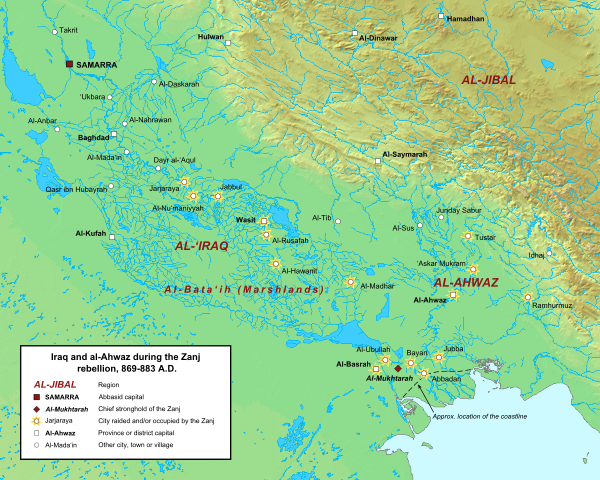
English: Map of the central Abbasid caliphate during the rebellion of the Zanj, from 869 to 883 A.D. All settlements on this map are listed by al-Tabari in his History of the Prophets and Kings, trans. "The History of al-Tabari," volumes 35 through 37. The location of cities and towns that no longer exist were determined using the maps of Le Strange and Popovic in their respective works.
Background topography taken from DEMIS Mapserver, which are public domain. Works Cited:
|
| Data | |
| Origem | Obra do próprio |
| Autor | Ro4444 |
Licenciamento
Eu, titular dos direitos de autor desta obra, publico-a com a seguinte licença:
A utilização deste ficheiro é regulada nos termos da licença Creative Commons - Atribuição-CompartilhaIgual 3.0 Não Adaptada.
- Pode:
- partilhar – copiar, distribuir e transmitir a obra
- recombinar – criar obras derivadas
- De acordo com as seguintes condições:
- atribuição – Tem de fazer a devida atribuição da autoria, fornecer uma hiperligação para a licença e indicar se foram feitas alterações. Pode fazê-lo de qualquer forma razoável, mas não de forma a sugerir que o licenciador o apoia ou subscreve o seu uso da obra.
- partilha nos termos da mesma licença – Se remisturar, transformar ou ampliar o conteúdo, tem de distribuir as suas contribuições com a mesma licença ou uma licença compatível com a original.
Histórico do ficheiro
Clique uma data e hora para ver o ficheiro tal como ele se encontrava nessa altura.
| Data e hora | Miniatura | Dimensões | Utilizador | Comentário | |
|---|---|---|---|---|---|
| atual | 14h42min de 16 de junho de 2015 | | 900 × 720 (1,2 MB) | Ro4444 | Changing location of al-Madhar to 31° 28' 23.4726" N, 47° 23' 4.4982", the location of the burial place of 'Abdallah ibn 'Ali ibn Abi Talib. See M. Streck, "Maisan," ''E.J. Brill's First Encyclopaedia of Islam, Volume V,'' (Leiden: E.J. Brill, 1927),... |
| 21h13min de 3 de março de 2013 |  | 900 × 720 (1,2 MB) | Ro4444 | User created page with UploadWizard |
Utilização local do ficheiro
As seguintes 3 páginas usam este ficheiro:
Utilização global do ficheiro
As seguintes wikis usam este ficheiro:
- ar.wikipedia.org
- arz.wikipedia.org
- azb.wikipedia.org
- ca.wikipedia.org
- cy.wikipedia.org
- de.wikipedia.org
- en.wikipedia.org
- es.wikipedia.org
- fa.wikipedia.org
- fr.wikipedia.org
- ga.wikipedia.org
- he.wikipedia.org
- id.wikipedia.org
- ms.wikipedia.org
- sv.wikipedia.org
- tr.wikipedia.org
- www.wikidata.org
- zh.wikipedia.org