Ficheiro:Africa independence dates.PNG

Dimensões desta antevisão: 564 × 600 píxeis. Outras resoluções: 226 × 240 píxeis | 451 × 480 píxeis | 752 × 800 píxeis.
Imagem numa resolução maior (752 × 800 píxeis, tamanho: 42 kB, tipo MIME: image/png)
|
|
Esta imagem provém do Wikimedia Commons, um acervo de conteúdo livre da Wikimedia Foundation que pode ser utilizado por outros projetos.
|

|
File:Africa independence dates.svg é uma versão vetorial deste ficheiro. Ela deve ser usada em vez desta imagem em formato raster, se não for de qualidade inferior.
File:Africa independence dates.PNG → File:Africa independence dates.svg
Para mais informações, consulte Ajuda:SVG. |
 |
Descrição do ficheiro
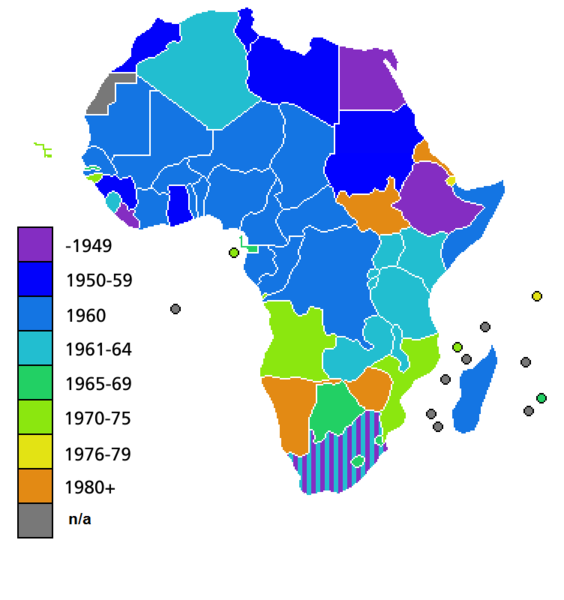
Español: Fechas de independencia de los países africanos.
Countries of Africa, with date of independence
Licenciamento

|
É concedida permissão para copiar, distribuir e/ou modificar este documento nos termos da Licença de Documentação Livre GNU, versão 1.2 ou qualquer versão posterior publicada pela Free Software Foundation; sem Secções Invariantes, sem textos de Capa e sem textos de Contra-Capa. É incluída uma cópia da licença na secção intitulada GNU Free Documentation License. |
| A utilização deste ficheiro é regulada nos termos da licença Creative Commons - Atribuição-CompartilhaIgual 3.0 Não Adaptada. | ||
| ||
| Esta marca de licenciamento foi adicionada a este ficheiro durante a atualização da licença GFDL. |
Histórico do ficheiro
Clique uma data e hora para ver o ficheiro tal como ele se encontrava nessa altura.
| Data e hora | Miniatura | Dimensões | Utilizador | Comentário | |
|---|---|---|---|---|---|
| atual | 04h25min de 9 de julho de 2011 | | 752 × 800 (42 kB) | Hoshie | added South Sudan to the map |
| 02h34min de 19 de junho de 2011 |  | 752 × 800 (42 kB) | Muso | Reverted to version as of 10:09, 22 April 2011 | |
| 02h19min de 19 de junho de 2011 |  | 752 × 800 (14 kB) | Muso | Zimbabwe got his independence in 1965, therefore correct its color from orange green | |
| 10h09min de 22 de abril de 2011 |  | 752 × 800 (42 kB) | Hoshie | added the French departements of Mayotte and Reunion and the Ilies Eparses distict of the TAAF; CIA maps was used as a source. A version w/ Southern Sudan is ready for July. | |
| 03h00min de 11 de abril de 2011 |  | 752 × 800 (42 kB) | Hoshie | added Cabinda (Angola) to the map; a version with Southern Sudan is ready once they declare independence in July. | |
| 18h16min de 6 de abril de 2010 |  | 752 × 800 (38 kB) | Lemonade100 | De Jure Independance of Zimbawe and South Africa (changed from de facto), St Helena and dependancies added. | |
| 01h35min de 23 de março de 2008 |  | 752 × 690 (36 kB) | Serg!o | UN considers Sahara as a colony - ONU considera Sahara como colonia | |
| 11h44min de 22 de março de 2006 |  | 752 × 690 (36 kB) | Roke~commonswiki | Countries of Africa, with date of independence Category: Maps of Africa Category: History of Africa |
Utilização local do ficheiro
Não há nenhuma página que use este ficheiro.
Utilização global do ficheiro
As seguintes wikis usam este ficheiro:
- bn.wikipedia.org
- el.wikivoyage.org
- en.wikipedia.org
- hi.wikipedia.org