Ficheiro:BagrationMap2.jpg
Dimensões desta antevisão: 788 × 600 píxeis. Outras resoluções: 315 × 240 píxeis | 631 × 480 píxeis | 1 009 × 768 píxeis | 1 256 × 956 píxeis.
Imagem numa resolução maior (1 256 × 956 píxeis, tamanho: 1,05 MB, tipo MIME: image/jpeg)
|
|
Esta imagem provém do Wikimedia Commons, um acervo de conteúdo livre da Wikimedia Foundation que pode ser utilizado por outros projetos.
|
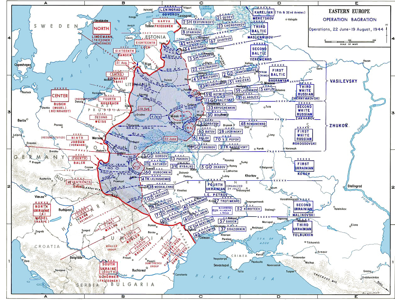
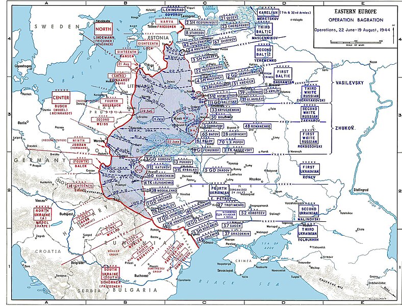
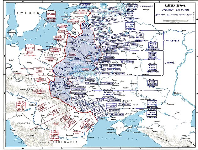
Operation Bagration -- June 22 - August 19, 1944
Source: US ARMY
Original Uploaded by GeneralPatton
http://www.jewishvirtuallibrary.org/jsource/ww2/easterneurope8.html
License: US Government document. Printed by the Government printing office. Assumed public domain.
Esta obra encontra-se no domínio público nos Estados Unidos por ser uma obra do Governo Federal dos EUA nos termos do Título 17, Capítulo 1, Secção 105 do US Code. Veja Copyright.
Nota: Este estatuto apenas se aplica a obras do Governo Federal, e não a obras de nenhum estado, condado, subdivisão ou município.
|
 | |
| Este ficheiro foi considerado livre de restrições conhecidas devidas a direitos de autor, incluindo todos os direitos conexos. | ||
Histórico do ficheiro
Clique uma data e hora para ver o ficheiro tal como ele se encontrava nessa altura.
| Data e hora | Miniatura | Dimensões | Utilizador | Comentário | |
|---|---|---|---|---|---|
| atual | 10h01min de 9 de abril de 2017 | | 1 256 × 956 (1,05 MB) | Claude Zygiel | Corrected borders of the time; rumanian communist divisions; cosmetics. |
| 15h28min de 20 de fevereiro de 2011 |  | 1 256 × 956 (527 kB) | Hohum | Cleanup | |
| 23h29min de 19 de junho de 2005 |  | 1 256 × 956 (334 kB) | Perconte~commonswiki | Operation Bagration -- June 22 - August 19, 1944 Source: US ARMY Original Uploaded by User:GeneralPatton License: US Government document. Printed by the Government printing office. Assumed public domain. {{PD}} |
Utilização local do ficheiro
A seguinte página usa este ficheiro:
Utilização global do ficheiro
As seguintes wikis usam este ficheiro:
- azb.wikipedia.org
- be-tarask.wikipedia.org
- bg.wikipedia.org
- ca.wikipedia.org
- cs.wikipedia.org
- da.wikipedia.org
- de.wikipedia.org
- el.wikipedia.org
- en.wikipedia.org
- Operation Bagration
- Hyacinth Graf Strachwitz
- Lvov-Sandomierz Offensive
- 14th Waffen Grenadier Division of the SS (1st Galician)
- June 1944
- Ivan Bagramyan
- Russian military deception
- Army Group North Ukraine
- User:Esdrasbarnevelt/Operation Bagration
- Operation Doppelkopf
- German radio intelligence operations during World War II
- es.wikipedia.org
- et.wikipedia.org
- fa.wikipedia.org
- fi.wikipedia.org
- fr.wikipedia.org
- he.wikipedia.org
Ver mais utilizações globais deste ficheiro.