Ficheiro:Bancdarguin oli 2019362.jpg

Imagem numa resolução maior(720 × 700 píxeis, tamanho: 372 kB, tipo MIME: image/jpeg)

Descrição do ficheiro

Descrição
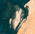
English: When viewed from space, the shoals, seagrass beds, and mudflats of Mauritania’s Banc d'Arguin National Park often blend with sand and sea in beautiful ways.

So it was on December 28, 2019, when the Operational Land Imager (OLI) on Landsat 8 captured this natural-color image of the park’s shallow coastal waters. The mostly barren dunes on the shore drew a contrast with the maze of coastal mudflats (dark brown) and shallow seagrass beds (green) that grow beneath a few meters of water. Deeper channels (dark blue) meander and flow among the sea grass and sandy shoals.

While signs of life are rare on this mostly arid land, the upwelling of cool, nutrient-rich water offshore causes the park’s coastal areas to burst with marine life. Whales, dolphins, and seals all make appearances. Thriving finfish and shellfish populations attract migratory birds to breeding sites here. Expansive tidal mudflats support upwards of 2 million shorebirds, making Banc d'Arguin one of the largest meeting places for Palaearctic birds in the world. Several endangered marine mammals occasionally turn up, notably monk seals and humpback dolphins.

But Landsat does more than deliver an occasional pretty picture. Scientists have analyzed 20 years of satellite observations and found that the park’s extensive seagrass beds have remained remarkably healthy and resilient, despite weathering occasional damage from storms and dust that temporarily killed grasses in certain areas.

NASA Earth Observatory image by Lauren Dauphin, using Landsat data from the U.S. Geological Survey. Caption by Adam Voiland.
Data December 28, 2019 JPEG
Origem https://earthobservatory.nasa.gov/images/146600/beautiful-banc-darguin-national-park?src=eoa-iotd
Autor NASA Earth Observatory
Permissão
(Reutilizar este ficheiro)
Public domain Este ficheiro está no domínio público nos Estados Unidos porque foi criado exclusivamente pela NASA. As orientações sobre o direito de autor da NASA são que «as obras da NASA não têm os direitos de autor protegidos salvo indicação em contrário». Veja Template:PD-USGov, as orientações sobre o direito de autor da NASA ou as normas de uso de imagens do Laboratório de Propulsão a Jato (Jet Propulsion Lab, JPL).
Avisos:

Legendas

Adicione uma explicação de uma linha do que este ficheiro representa

Elementos retratados neste ficheiro

retrata

image/jpeg

4dac0ac38b14bd0844300136a718fabeb0aabd5a

381 175 byte

700 pixel

720 pixel

Histórico do ficheiro

Clique uma data e hora para ver o ficheiro tal como ele se encontrava nessa altura.

Data e horaMiniaturaDimensõesUtilizadorComentário
atual13h53min de 23 de abril de 2020Miniatura da versão das 13h53min de 23 de abril de 2020720 × 700 (372 kB)Tillman{{Information |description ={{en|1=When viewed from space, the shoals, seagrass beds, and mudflats of Mauritania’s Banc d'Arguin National Park often blend with sand and sea in beautiful ways. So it was on December 28, 2019, when the Operational Land Imager (OLI) on Landsat 8 captured this natural-color image of the park’s shallow coastal waters. The mostly barren dunes on the shore drew a contrast with the maze of coastal mudflats (dark brown) and shallow seagrass beds (green) that grow be...

As seguintes 2 páginas usam este ficheiro:

Utilização global do ficheiro

As seguintes wikis usam este ficheiro: