Ficheiro:Battle of the Canal du Nord - battle map (Sept 1918).jpg

Dimensões desta antevisão: 800 × 516 píxeis. Outras resoluções: 320 × 206 píxeis | 640 × 413 píxeis | 1 024 × 660 píxeis | 1 280 × 825 píxeis | 2 560 × 1 651 píxeis | 6 828 × 4 403 píxeis.
Imagem numa resolução maior (6 828 × 4 403 píxeis, tamanho: 27,12 MB, tipo MIME: image/jpeg)
|
|
Esta imagem provém do Wikimedia Commons, um acervo de conteúdo livre da Wikimedia Foundation que pode ser utilizado por outros projetos.
|
Descrição do ficheiro
| Descrição |
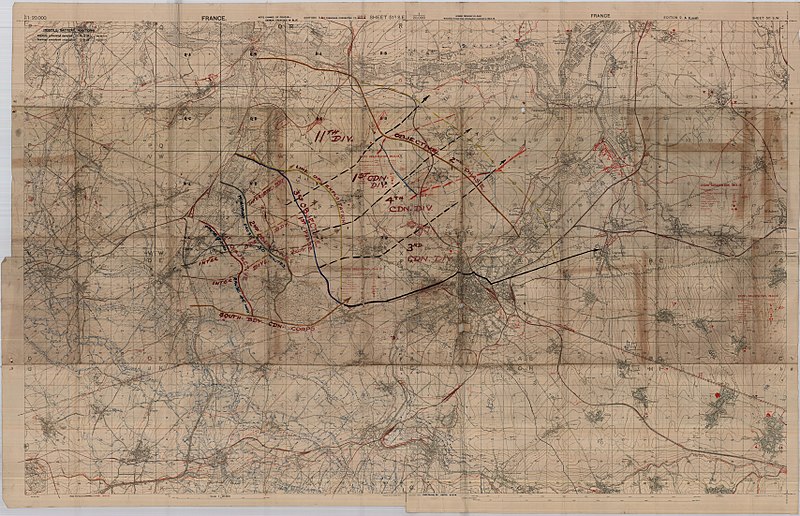
English: High Resolution Barrage Map [1:20,000]. Light linen backing. Trenches corrected to 20-8-18. four complete adjacent maps joined to form one large map. Lines indicating inter-brigade boundaries as well as the southern boundary of the Canadian Corps. Lines also indicating 1st, 2nd and 3rd Canadian Division objectives. Sheet numbers: 51b SE, 51a SW, 57c NE, 57b NW |
||||||||||||||||||||
| Data | |||||||||||||||||||||
| Origem | McMaster University, Fonds: WW1 Trench Maps: France, Box no. 10, Envelope no. 001, Database Number 433 | ||||||||||||||||||||
| Criador |
War Office. General Staff. Geographical Section, Field Service Battalion, Royal Engineers |
||||||||||||||||||||
| Permissão (Reutilizar este ficheiro) |
|
||||||||||||||||||||
| Dados geotemporais | |||||||||||||||||||||
| Data retratada | |||||||||||||||||||||
| Localização no mapa | Cambrai | ||||||||||||||||||||
| Tipo de mapa | trench map | ||||||||||||||||||||
| Escala | 1:20,000 | ||||||||||||||||||||
| Orientação |
 |
||||||||||||||||||||
| Caixa delimitadora |
|
||||||||||||||||||||
| Georeferenciamento | |||||||||||||||||||||
| Dados bibliográficos | |||||||||||||||||||||
| Folha do mapa | 51 & 57 | ||||||||||||||||||||
| Língua | inglês | ||||||||||||||||||||
| Editora |
Royal Engineers |
||||||||||||||||||||
| Dados de arquivamento | |||||||||||||||||||||
| Coleção |
|
||||||||||||||||||||


.jpg)
Histórico do ficheiro
Clique uma data e hora para ver o ficheiro tal como ele se encontrava nessa altura.
| Data e hora | Miniatura | Dimensões | Utilizador | Comentário | |
|---|---|---|---|---|---|
| atual | 21h24min de 11 de junho de 2018 | | 6 828 × 4 403 (27,12 MB) | Labattblueboy | higher resolution |
| 04h06min de 7 de junho de 2009 |  | 9 833 × 6 341 (11,07 MB) | Labattblueboy | {{Information |Description= High Resolution Barrage Map [][1:20,000]. Light linen backing. Trenches corrected to 20-8-18. four complete adjacent maps joined to form one large map. Lines indicating inter-brigade boundaries as well as the southern boundary |
Utilização local do ficheiro
A seguinte página usa este ficheiro:
Utilização global do ficheiro
As seguintes wikis usam este ficheiro:
- en.wikipedia.org
.jpg)