Ficheiro:C72189s1 Ant.Map Cape Hallet.jpg
Dimensões desta antevisão: 712 × 599 píxeis. Outras resoluções: 285 × 240 píxeis | 570 × 480 píxeis | 912 × 768 píxeis | 1 216 × 1 024 píxeis | 2 432 × 2 048 píxeis | 3 860 × 3 250 píxeis.
Imagem numa resolução maior (3 860 × 3 250 píxeis, tamanho: 2,26 MB, tipo MIME: image/jpeg)
|
|
Esta imagem provém do Wikimedia Commons, um acervo de conteúdo livre da Wikimedia Foundation que pode ser utilizado por outros projetos.
|
Descrição do ficheiro
| Descrição |
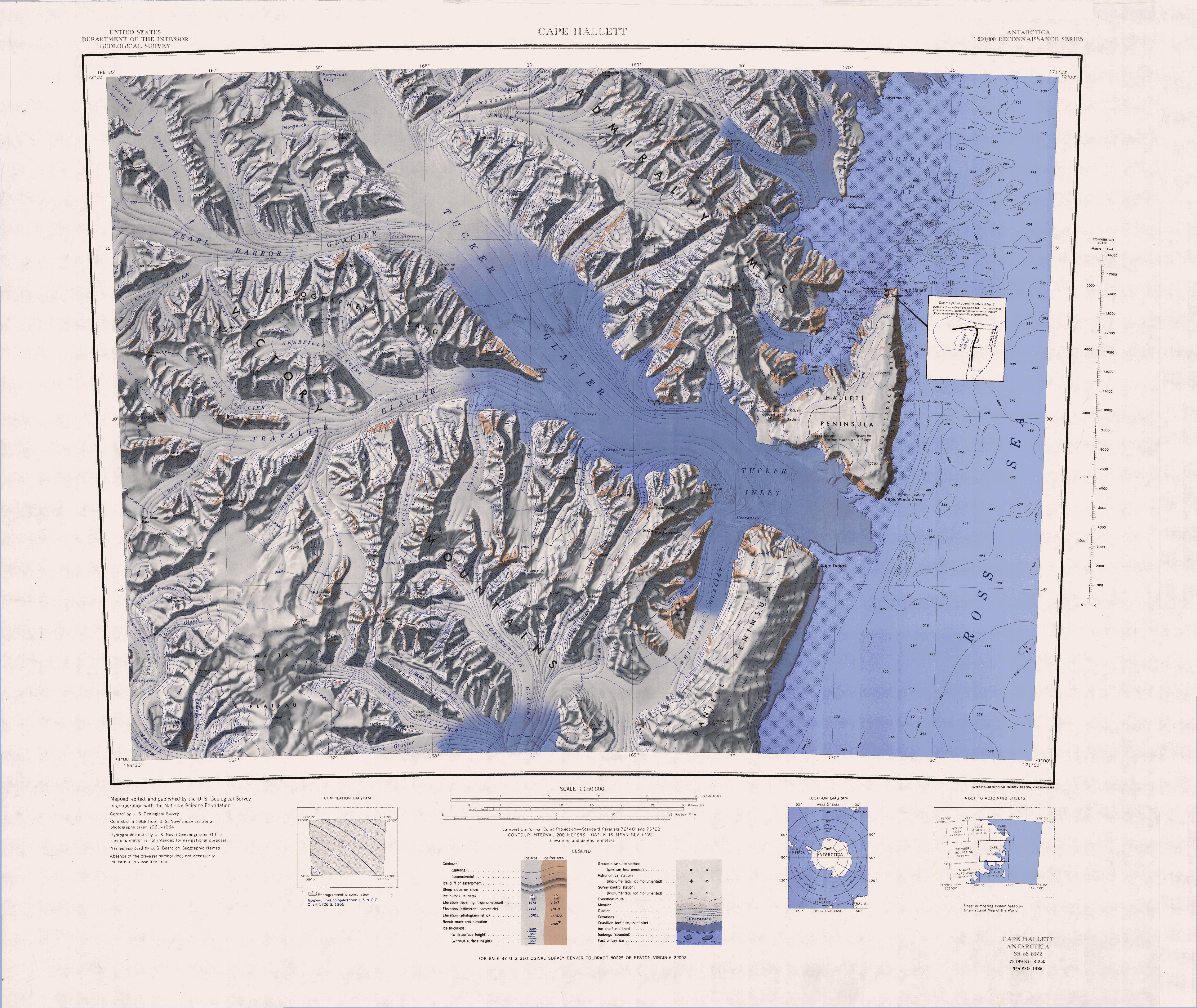
English: 1:250,000-scale topographic reconnaissance map of the Cape Hallet area from 159°-162°E to 71°-72°S in Antarctica, including the Tucker Glacier. Mapped, edited and published by the U.S. Geological Survey in cooperation with the National Science Foundation. |
|||
| Data | ||||
| Origem | http://usarc.usgs.gov/drg_dload.shtml | |||
| Autor | United States Geological Survey | |||
| Permissão (Reutilizar este ficheiro) |
|
|||
| Outras versões | Obras derivadas deste ficheiro: Latino Peak.jpg |
Histórico do ficheiro
Clique uma data e hora para ver o ficheiro tal como ele se encontrava nessa altura.
| Data e hora | Miniatura | Dimensões | Utilizador | Comentário | |
|---|---|---|---|---|---|
| atual | 17h40min de 3 de abril de 2005 | | 3 860 × 3 250 (2,26 MB) | Achim Raschka | Map of Antarctica by the United States Antarctic Ressource Center of the US Geological Society. {{PD-US}} Copyrights and Trademarks USGS-authored or produced data and information are in the public domain. While the content of most USGS web pages is in th |
Utilização local do ficheiro
A seguinte página usa este ficheiro:
Utilização global do ficheiro
As seguintes wikis usam este ficheiro:
- bg.wikipedia.org
- ceb.wikipedia.org
- de.wikipedia.org
- Kap Hallett
- Admiralitätsberge
- Mount Herschel
- Tucker-Gletscher
- Mariner-Gletscher
- McGregor Range (Antarktika)
- Moubray Bay
- Hallett-Halbinsel
- Edisto Inlet
- Kap Wheatstone
- Tucker Inlet
- Daniell-Halbinsel
- Whitehall-Gletscher
- Victory Mountains
- Malta-Plateau
- Trafalgar-Gletscher
- Pearl-Harbor-Gletscher
- Arneb-Gletscher
- Redcastle Ridge
- Edisto-Gletscher
- Felsite Island
- Honeycomb Ridge
- Quartermain Point
- Helm Point
- Biscuit Step
- Bornmann-Gletscher
- Seabee Hook
- Jütland-Gletscher
- Mount Bridger
- Bridgman-Gletscher
- Salmon-Kliff
- Roberts-Kliff
- Mount Chider
- Mount Hart
- Construction Point
- Willett Cove
- Copper Cove
- Cotter-Kliffs
- Coulston-Gletscher
- DeWald-Gletscher
Ver mais utilizações globais deste ficheiro.