Ficheiro:Cumulonimbus cloud over Africa.jpg

Imagem numa resolução maior(3 032 × 2 008 píxeis, tamanho: 732 kB, tipo MIME: image/jpeg)

Descrição do ficheiro

Descrição
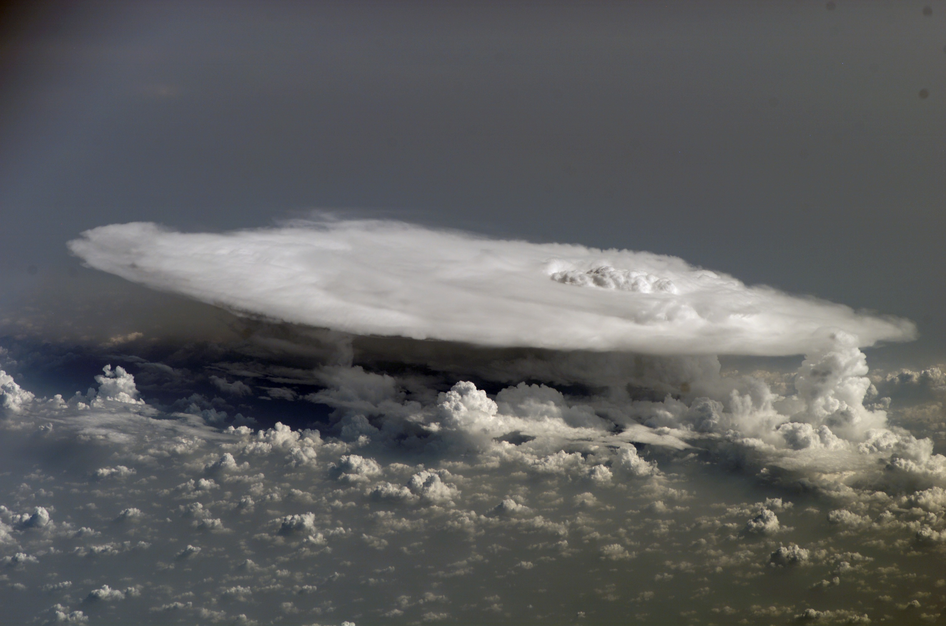
English: A cumulonimbus cloud over Africa, common in tropical latitudes year-round and during the summer season at higher latitudes.


International Space Station InsigniaISS Crew Earth Observations: ISS016-E-27426International Space Station Insignia
Identification
Mission ISS016 (Expedition 16)
Roll E
Frame 27426
Country or Geographic Name AFRICA
Features PAN-LARGE THUNDERSTORM ANVIL
Camera
Camera Tilt High Oblique
Camera Focal Length 400 mm
Camera Kodak DCS760C Electronic Still Camera
Film 3060 x 2036 pixel CCD, RGBG array.
Quality
Percentage of Cloud Cover 26-50%
Nadir What is Nadir?
Date 2008-02-05
Time 15:10:24
Nadir Point Latitude 13.5° N
Nadir Point Longitude -12.0° E
Sun Azimuth 228°
Spacecraft Altitude 179 nautical miles (332 km)
Sun Elevation Angle 47°
Orbit Number 761
Original image caption
Cumulonimbus Cloud over Africa

Perhaps the most impressive of cloud formations, cumulonimbus (from the Latin for “pile” and “rain cloud”) clouds form due to vigorous convection (rising and overturning) of warm, moist, and unstable air. Surface air is warmed by the Sun-heated ground surface and rises; if sufficient atmospheric moisture is present, water droplets will condense as the air mass encounters cooler air at higher altitudes. The air mass itself also expands and cools as it rises due to decreasing atmospheric pressure, a process known as adiabatic cooling. This type of convection is common in tropical latitudes year-round and during the summer season at higher latitudes.

As water in the rising air mass condenses and changes from a gas to a liquid state, it releases energy to its surroundings, further heating the surrounding air and leading to more convection and rising of the cloud mass to higher altitudes. This leads to the characteristic vertical “towers” associated with cumulonimbus clouds, an excellent example of which is visible in this astronaut photograph. If enough moisture is present to condense and heat the cloud mass through several convective cycles, a tower can rise to altitudes of approximately 10 kilometers at high latitudes and to 20 kilometers in the tropics before encountering a region of the atmosphere known as the tropopause—the boundary between the troposphere and the stratosphere.

The tropopause is characterized by a strong temperature inversion. Beyond the tropopause, the air no longer gets colder as altitude increases. The tropopause halts further upward motion of the cloud mass. The cloud tops flatten and spread into an anvil shape, as illustrated by this astronaut photograph. The photo was taken from a viewpoint that was at an angle from the vertical, rather than looking straight down towards the Earth’s surface. The image, taken while the International Space Station was located over western Africa near the Senegal-Mali border, shows a fully formed anvil cloud with numerous smaller cumulonimbus towers rising near it. The high energy levels of these storm systems typically make them hazardous due to associated heavy precipitation, lightning, high wind speeds and possible tornadoes.

Data
Origem http://spaceflight.nasa.gov/gallery/images/station/crew-16/html/iss016e027426.html
Autor NASA
Este(a) imagem ou vídeo foi catalogado(a) por Centro Espacial Johnson dos Estados Unidos da América para a Administração Nacional da Aeronáutica e do Espaço (NASA), sobre o código ID: ISS016-E-027426.

Esta marcação não indica o estado dos direitos de autor da obra aqui mostrada. Continua a ser necessária uma marcação normal de direitos de autor. Veja Commons:Licenciamento para mais informações.
Outras línguas:

Licenciamento

Public domain
"The Gateway to Astronaut Photography of Earth". Esta imagem é uma cortesia do Laboratório de Ciências e Análises do Centro Espacial Johnson da NASA.
Fonte: ISS016-E-27426.

العربيَّة | Deutsch | English | español | français | italiano | kurdî | македонски | മലയാളം | português | sicilianu | +/−

Legendas

Adicione uma explicação de uma linha do que este ficheiro representa

Elementos retratados neste ficheiro

retrata

Histórico do ficheiro

Clique uma data e hora para ver o ficheiro tal como ele se encontrava nessa altura.

Data e horaMiniaturaDimensõesUtilizadorComentário
atual23h18min de 1 de junho de 2013Miniatura da versão das 23h18min de 1 de junho de 20133 032 × 2 008 (732 kB)Ras67losslessly cropped with Jpegcrop
00h35min de 22 de outubro de 2011Miniatura da versão das 00h35min de 22 de outubro de 20113 032 × 2 064 (742 kB)Rehman

A seguinte página usa este ficheiro:

Utilização global do ficheiro

As seguintes wikis usam este ficheiro:

Metadados