Ficheiro:D'Anville Amérique Septentrionale 1746 UTA 2.jpg

Imagem numa resolução maior (10 547 × 5 851 píxeis, tamanho: 7,95 MB, tipo MIME: image/jpeg)
|
|
Esta imagem provém do Wikimedia Commons, um acervo de conteúdo livre da Wikimedia Foundation que pode ser utilizado por outros projetos.
|
Descrição do ficheiro
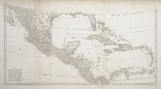
| Título |
Français : Amérique Septentrionale |
||||||||||||||||||||||||||||||||||||||||||||||
| Descrição |
English: The research d'Anville conducted for this map included reading several decades' worth of exploration and travel narratives as well as maps by his predecessors and contemporaries, yet he realized there were still vast areas of the continent where nothing was yet known. D'Anville's map of North America corrected much of the exaggerations and distortions found on Delisle's earlier maps, adding newer, more precise information about the shapes of the Great Lakes and the configuration of the Mississippi basin, including the lower Missouri, Arkansas, and lower Red Rivers. Along the lower Missouri, for example, d'Anville depicted Fort d'Orléans (established in 1723) after carefully studying accounts by its founder, Étienne de Veniard, Sieur de Bourgmont (1679-1734), who had returned to France in 1725 with his Missouria wife and a number of Native American tribal representatives. Important sources for the Gulf coast were the field survey maps of French engineer Valentin Devin (d. 1735), who had first arrived in Louisiana in 1719. |
||||||||||||||||||||||||||||||||||||||||||||||
| Data | |||||||||||||||||||||||||||||||||||||||||||||||
| Origem | UTA Libraries Cartographic Connections: mapa / texto | ||||||||||||||||||||||||||||||||||||||||||||||
| Criador |
|
||||||||||||||||||||||||||||||||||||||||||||||
| Modo de aquisição |
English: The University of Texas at Arlington Libraries Special Collections |
||||||||||||||||||||||||||||||||||||||||||||||
| Dados geotemporais | |||||||||||||||||||||||||||||||||||||||||||||||
| Localização no mapa |
México América Central Caraíbas |
||||||||||||||||||||||||||||||||||||||||||||||
| Georeferenciamento | Se inapropriado, por favor defina warp_status = skip para ocultar. | ||||||||||||||||||||||||||||||||||||||||||||||
| Dados bibliográficos | |||||||||||||||||||||||||||||||||||||||||||||||
| Autor |
|
||||||||||||||||||||||||||||||||||||||||||||||
| Local de publicação | Paris | ||||||||||||||||||||||||||||||||||||||||||||||
| Impresso por |
|
||||||||||||||||||||||||||||||||||||||||||||||
| Dados de arquivamento | |||||||||||||||||||||||||||||||||||||||||||||||
| Coleção |
|
||||||||||||||||||||||||||||||||||||||||||||||
| Dimensões | altura: 46 cm; largura: 87 cm | ||||||||||||||||||||||||||||||||||||||||||||||
| Técnica | gravura colorido a mão sobre papel | ||||||||||||||||||||||||||||||||||||||||||||||
| Inscrições |
Français : Publiée sous les auspices de Monseigneur le duc d'Orleans, prémier prince du sang / par le Sr. D'Anville, MDCCXLVI. |
||||||||||||||||||||||||||||||||||||||||||||||
| artwork-references |
L'Italien, Raymonde; Jean-François Palomino, Denis Vaugeois; Kathe Roth, transl. (1995) Mapping a Continent: Historical Atlas of North America, 1492-1814, Sillery, Quebec: Les editions du Septentrion, pp. 58−96 Jackson, Jack (2007) Flags Along the Coast: Charting the Gulf of Mexico, 1519-1759: A Reappraisal, Austin: The Book Club of Texas, p. 193 Huseman, Ben W. (2016) Enlightenment Mapmakers and the Southwest Borderlands: Treasures from the Virginia Garrett Cartographic History Library, Arlington: UTA Libraries Special Collections, nr 13 , pp. 16−17 |
||||||||||||||||||||||||||||||||||||||||||||||
| Outras versões |
|
||||||||||||||||||||||||||||||||||||||||||||||


Licenciamento

|
This file was provided to Wikimedia Commons by the University of Texas at Arlington Libraries as part of a cooperation project. The University of Texas at Arlington Libraries is part of the University of Texas at Arlington, a public research university located in Arlington, Texas.
|
|
O autor faleceu em 1782, portanto esta obra está no domínio público no seu país de origem e noutros países e áreas onde o período de proteção dos direitos de autor é igual ou inferior à vida do autor mais 100 anos. Esta obra está no domínio público nos Estados Unidos porque foi publicada (ou registada no U.S. Copyright Office) antes de 1 de janeiro de 1929. | |
| Este ficheiro foi considerado livre de restrições conhecidas devidas a direitos de autor, incluindo todos os direitos conexos. | |
Histórico do ficheiro
Clique uma data e hora para ver o ficheiro tal como ele se encontrava nessa altura.
| Data e hora | Miniatura | Dimensões | Utilizador | Comentário | |
|---|---|---|---|---|---|
| atual | 20h18min de 29 de maio de 2019 | | 10 547 × 5 851 (7,95 MB) | Michael Barera | == {{int:filedesc}} == {{Map |title = ''Amérique Septentrionale'' |description = {{en|The research d'Anville conducted for this map included reading several decades' worth of exploration and travel narratives as well as maps by his predecessors and contemporaries, yet he realized there were still vast areas of the continent where nothing was yet known. D'Anville's map of North America corrected much of the exaggerations and distortions found on Delisle's earlier maps, addi... |
Utilização local do ficheiro
A seguinte página usa este ficheiro:
Utilização global do ficheiro
As seguintes wikis usam este ficheiro:
- de.wikipedia.org
- en.wikipedia.org
- fr.wikipedia.org
- it.wikipedia.org