Ficheiro:Dallas Boomburbs.gif

Dimensões desta antevisão: 800 × 600 píxeis. Outras resoluções: 320 × 240 píxeis | 640 × 480 píxeis | 1 024 × 768 píxeis | 1 280 × 960 píxeis | 2 560 × 1 920 píxeis | 4 000 × 3 000 píxeis.
Imagem numa resolução maior (4 000 × 3 000 píxeis, tamanho: 18,79 MB, tipo MIME: image/gif, cíclico, 2 quadros, 4,0 s)
|
|
Esta imagem provém do Wikimedia Commons, um acervo de conteúdo livre da Wikimedia Foundation que pode ser utilizado por outros projetos.
|
Descrição do ficheiro
| Descrição |
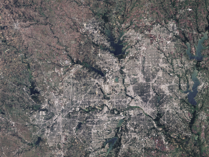
English: These images show three boom-burbs, Irving, Carrollton, and Plano—along the north-eastern margin of the Dallas Metropolitan area. Between August 31, 1984 and August 4, 2009, each of these suburbs grew explosively, filling in the patchwork of agricultural lands to the north and west of Dallas. Irving expanded westward to the Dallas-Fort Worth airport and northward to North Lake. Carrollton grew north-west toward Lake Lewisville, while Plano completely filled the territory between two tree-lined creeks. |
| Data | |
| Origem | NASA Earth Observatory |
| Autor | Jesse Allen |
Images captured by NASA’s Landsat 5 satellite.
Licenciamento
| Este ficheiro está no domínio público nos Estados Unidos porque foi criado exclusivamente pela NASA. As orientações sobre o direito de autor da NASA são que «as obras da NASA não têm os direitos de autor protegidos salvo indicação em contrário». Veja Template:PD-USGov, as orientações sobre o direito de autor da NASA ou as normas de uso de imagens do Laboratório de Propulsão a Jato (Jet Propulsion Lab, JPL). | ||
 |
Avisos:
|
| Anotações | Esta imagem está anotada: Ver as anotações na wiki Commons |
Histórico do ficheiro
Clique uma data e hora para ver o ficheiro tal como ele se encontrava nessa altura.
| Data e hora | Miniatura | Dimensões | Utilizador | Comentário | |
|---|---|---|---|---|---|
| atual | 11h36min de 8 de fevereiro de 2010 | | 4 000 × 3 000 (18,79 MB) | Originalwana | {{Information |Description={{en|1=These images show three boom-burbs, Irving, Carrollton, and Plano—along the north-eastern margin of the Dallas Metropolitan area. Between August 31, 1984 and August 4, 2009, each of these s |
Utilização local do ficheiro
A seguinte página usa este ficheiro: