Ficheiro:Hannan city center area Aerial photograph.1985.jpg

Dimensões desta antevisão: 515 × 600 píxeis. Outras resoluções: 206 × 240 píxeis | 412 × 480 píxeis | 659 × 768 píxeis | 879 × 1 024 píxeis | 1 758 × 2 048 píxeis | 5 272 × 6 141 píxeis.
Imagem numa resolução maior (5 272 × 6 141 píxeis, tamanho: 21,41 MB, tipo MIME: image/jpeg)
|
|
Esta imagem provém do Wikimedia Commons, um acervo de conteúdo livre da Wikimedia Foundation que pode ser utilizado por outros projetos.
|
Descrição do ficheiro
| Descrição |
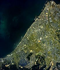
English: Hannan city center area Aerial photograph.1985
日本語: 阪南市(大阪府)中心部周辺の空中写真。ckk-85-2_c16の1,2,3、ckk-85-2_c17の1,2,3、ckk-85-2_c18の4,5,6、合計9枚を合成作成。 |
| Data | |
| Origem | 国土情報ウェブマッピングシステム |
| Autor | 国土交通省 |
Licenciamento

|
O titular dos direitos de autor deste ficheiro, the Ministry of Land, Infrastructure, Transport and Tourism of Japan, autoriza o seu uso por qualquer pessoa para qualquer finalidade, com a condição de que a sua autoria seja devidamente atribuída. A redistribuição, obras derivadas, uso comercial e todos os demais usos são permitidos. |
Atribuição:
Copyright © National Land Image Information (Color Aerial Photographs), Ministry of Land, Infrastructure, Transport and Tourism
|
 |
This image is copyrighted by the Ministry of Land, Infrastructure, Transport and Tourism of Japan. For terms of use, see the stipulation to use of National Land Information (in Japanese) and message from MLIT (in Japanese and English). When you display this image on an article, include the following phrase in the description: "Made based on National Land Image Information (Color Aerial Photographs), Ministry of Land, Infrastructure, Transport and Tourism".
|
Histórico do ficheiro
Clique uma data e hora para ver o ficheiro tal como ele se encontrava nessa altura.
| Data e hora | Miniatura | Dimensões | Utilizador | Comentário | |
|---|---|---|---|---|---|
| atual | 16h13min de 18 de março de 2014 | | 5 272 × 6 141 (21,41 MB) | さかおり | {{Information |Description ={{en|1=Hannan city center area Aerial photograph.1985}} {{ja|1=阪南市(大阪府)中心部周辺の空中写真。ckk-85-2_c16の1,2,3、ckk-85-2_c17の1,2,3、ckk-85-2_c18の4,5,6、合計9枚を合成作成。}} |... |
Utilização local do ficheiro
A seguinte página usa este ficheiro:
Utilização global do ficheiro
As seguintes wikis usam este ficheiro:
- ja.wikipedia.org
- pl.wikipedia.org