Ficheiro:Homann Planiglobii Terrestris Cumutroq Hemisphaerio Caelesti Generalis Exhibitio 1707 UTA.jpg

Imagem numa resolução maior (3 103 × 2 688 píxeis, tamanho: 2,35 MB, tipo MIME: image/jpeg)
|
|
Esta imagem provém do Wikimedia Commons, um acervo de conteúdo livre da Wikimedia Foundation que pode ser utilizado por outros projetos.
|
Descrição do ficheiro
| Título |
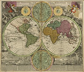
Latina: Planiglobii Terrestris cum Utroq Hemisphaerio Caelesti Generalis Exhibitio... |
||||||||||||||||||||||||||
| Descrição |
English: This double-hemisphere world map features insets of the celestial northern hemisphere and the celestial southern hemisphere, both of which show the mythological figures and objects of the constellations. Windheads and illustrations of a volcanic eruption, earthquake, tides, water-spouts, and a rainbow decorate the four corners of the composition. The map shows California as insular and traces the sailing routes of the explorers Magellan, Olivier van Noort, William Dampier, Abel Tasman, and Juan Gaetano.
Nuremberg cartographer and map publisher Homann and his family later produced a number of celestial and selenographical (lunar) charts in conjunction with the Nuremberg astronomer and mathematician Johann Gabriel Doppelmayr (1677-1750). Many of these charts were featured in Doppelmayr's Atlas coelestis, which Homann's Heirs published in 1742. |
||||||||||||||||||||||||||
| Data | |||||||||||||||||||||||||||
| Origem | UTA Libraries Cartographic Connections: mapa / texto | ||||||||||||||||||||||||||
| Criador |
|
||||||||||||||||||||||||||
| Modo de aquisição |
English: UTA Libraries Special Collections, Gift of Virginia Garrett |
||||||||||||||||||||||||||
| Georeferenciamento | Se inapropriado, por favor defina warp_status = skip para ocultar. | ||||||||||||||||||||||||||
| Dados bibliográficos | |||||||||||||||||||||||||||
| Publicação |
Atlas Novus Terrarum Orbis Imperia |
||||||||||||||||||||||||||
| Autor |
|
||||||||||||||||||||||||||
| Local de publicação | Nuremberga | ||||||||||||||||||||||||||
| Editora |
|
||||||||||||||||||||||||||
| Dados de arquivamento | |||||||||||||||||||||||||||
| Coleção |
|
||||||||||||||||||||||||||
| Dimensões | altura: 49 cm; largura: 57,2 cm | ||||||||||||||||||||||||||
| Técnica | gravura colorido | ||||||||||||||||||||||||||
| artwork-references |
Moreland e Bannister. "Homann Heirs". Error: journal= not stated. Warner, Deborah J. (1979) The Sky Explored: Celestial Cartography 1500-1800, Nova Iorque: Alan R. Liss, Inc., p. 120 |
||||||||||||||||||||||||||
.jpg)
Licenciamento

|
This file was provided to Wikimedia Commons by the University of Texas at Arlington Libraries as part of a cooperation project. The University of Texas at Arlington Libraries is part of the University of Texas at Arlington, a public research university located in Arlington, Texas.
|
|
O autor faleceu em 1724, portanto esta obra está no domínio público no seu país de origem e noutros países e áreas onde o período de proteção dos direitos de autor é igual ou inferior à vida do autor mais 100 anos. Esta obra está no domínio público nos Estados Unidos porque foi publicada (ou registada no U.S. Copyright Office) antes de 1 de janeiro de 1929. | |
| Este ficheiro foi considerado livre de restrições conhecidas devidas a direitos de autor, incluindo todos os direitos conexos. | |
Histórico do ficheiro
Clique uma data e hora para ver o ficheiro tal como ele se encontrava nessa altura.
| Data e hora | Miniatura | Dimensões | Utilizador | Comentário | |
|---|---|---|---|---|---|
| atual | 21h22min de 10 de fevereiro de 2022 | | 3 103 × 2 688 (2,35 MB) | Michael Barera | == {{int:filedesc}} == {{Map |title = {{la|'''''laniglobii Terrestris cum Utroq Hemisphaerio Caelesti Generalis Exhibitio...'''''}} |description = {{en|This double-hemisphere world map features insets of the celestial northern hemisphere and the celestial southern hemisphere, both of which show the mythological figures and objects of the constellations. Windheads and illustrations of a volcanic eruption, earthquake, tides, water-spouts, and a rainbow decorate the four corn... |
Utilização local do ficheiro
As seguintes 2 páginas usam este ficheiro:
Utilização global do ficheiro
As seguintes wikis usam este ficheiro:
- de.wikipedia.org
- en.wikipedia.org
- es.wikipedia.org
- fa.wikipedia.org
- fr.wikipedia.org
- id.wikipedia.org
- la.wikipedia.org
- nl.wikipedia.org
- ro.wikipedia.org
- ru.wikipedia.org
- sr.wikipedia.org
- sv.wikipedia.org
- uk.wikipedia.org