Ficheiro:Karte Hoch und Niederburgund EN.png

Dimensões desta antevisão: 564 × 600 píxeis. Outras resoluções: 226 × 240 píxeis | 452 × 480 píxeis | 722 × 768 píxeis | 963 × 1 024 píxeis | 2 000 × 2 126 píxeis.
Imagem numa resolução maior (2 000 × 2 126 píxeis, tamanho: 538 kB, tipo MIME: image/png)
|
|
Esta imagem provém do Wikimedia Commons, um acervo de conteúdo livre da Wikimedia Foundation que pode ser utilizado por outros projetos.
|
Descrição do ficheiro
| Descrição |
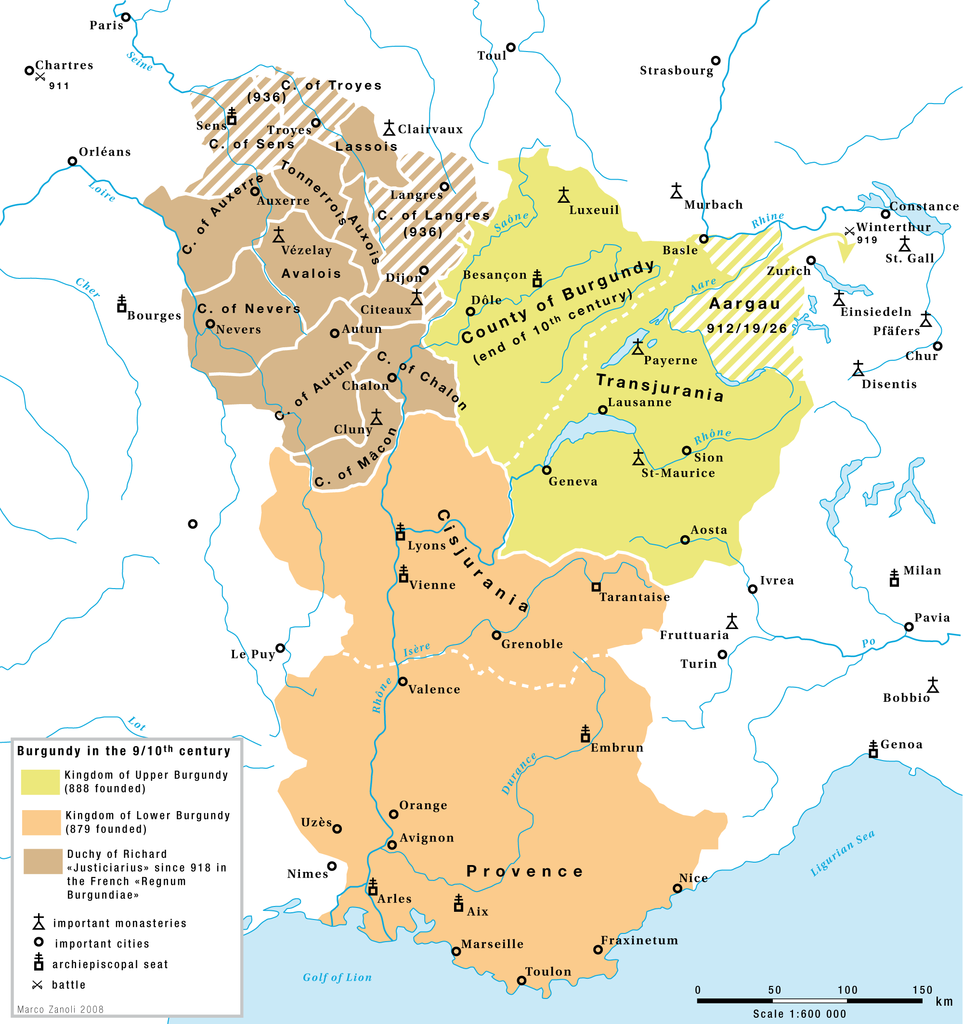
English: Burgundy in the 9th and 10th century: The kingdoms of Upper-Burgundy, Lower-Burgundy and the Duchy of Richard the Justiciar in the French part of the old Burgundian Kindom. |
| Data | |
| Origem | Obra do próprio |
| Autor | Marco Zanoli (Sidonius) |
| Outras versões |
|


Licenciamento
You may use my work outside wikipedia for free as long as you name me as the author. If you would like to use my work in a print medium, please send me a specimen copy.
Contact me if you have questions regarding the license or if you want individual changes to the map (marco.zanoli at hotmail.ch). A utilização deste ficheiro é regulada nos termos da licença Creative Commons Atribuição-CompartilhaIgual 4.0 Internacional. Atribuição: Marco Zanoli
|
Histórico do ficheiro
Clique uma data e hora para ver o ficheiro tal como ele se encontrava nessa altura.
| Data e hora | Miniatura | Dimensões | Utilizador | Comentário | |
|---|---|---|---|---|---|
| atual | 14h14min de 24 de fevereiro de 2018 | | 2 000 × 2 126 (538 kB) | Sidonius | a few corrections |
| 04h54min de 4 de julho de 2010 |  | 1 310 × 1 338 (192 kB) | DcoetzeeBot | Remove watermark, add author and license data to image metadata, decrease filesize with pngcrush | |
| 16h29min de 13 de fevereiro de 2009 |  | 1 310 × 1 338 (319 kB) | Sidonius | small corrections | |
| 14h24min de 13 de fevereiro de 2009 |  | 1 310 × 1 338 (318 kB) | Sidonius | == Beschreibung == {{Information |Description={{EN|1=Burgundy in the 9th and 10th century: The kingdoms of Upper-Burgundy, Lower-Burgundy and the Duchy of Richard the Justiciar in the French part of the old Burgundian Kindom.}} |Source=Eigenes Werk (own w |
Utilização local do ficheiro
As seguintes 2 páginas usam este ficheiro:
Utilização global do ficheiro
As seguintes wikis usam este ficheiro:
- af.wikipedia.org
- ar.wikipedia.org
- be.wikipedia.org
- bg.wikipedia.org
- bs.wikipedia.org
- ca.wikipedia.org
- cs.wikipedia.org
- en.wikipedia.org
- eo.wikipedia.org
- es.wikipedia.org
- et.wikipedia.org
- eu.wikipedia.org
- fr.wikipedia.org
Ver mais utilizações globais deste ficheiro.