Ficheiro:Lane 2012 track.png

Dimensões desta antevisão: 800 × 495 píxeis. Outras resoluções: 320 × 198 píxeis | 640 × 396 píxeis | 1 024 × 633 píxeis | 1 280 × 791 píxeis | 2 700 × 1 669 píxeis.
Imagem numa resolução maior (2 700 × 1 669 píxeis, tamanho: 417 kB, tipo MIME: image/png)
|
|
Esta imagem provém do Wikimedia Commons, um acervo de conteúdo livre da Wikimedia Foundation que pode ser utilizado por outros projetos.
|
Descrição do ficheiro
| Descrição |
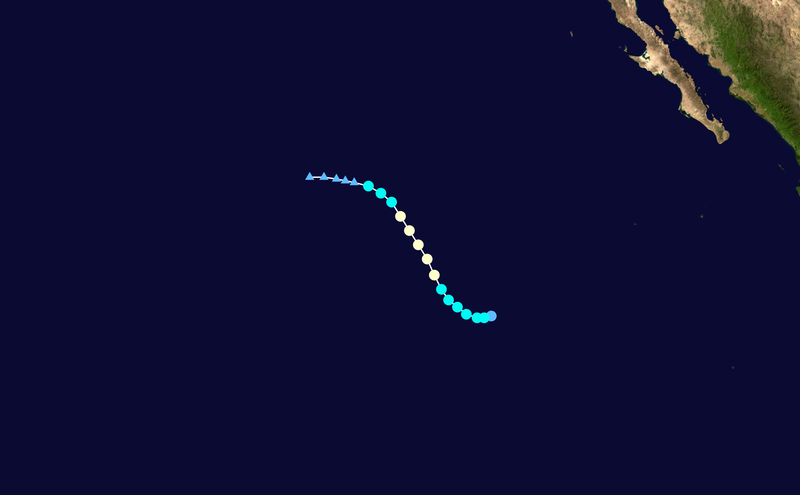
English: Track map of Hurricane Lane of the 2012 Pacific hurricane season. The points show the location of the storm at 6-hour intervals. The colour represents the storm's maximum sustained wind speeds as classified in the (see below), and the shape of the data points represent the nature of the storm, according to the legend below. Tropical depression (≤38 mph, ≤62 km/h)
Tropical storm (39–73 mph, 63–118 km/h)
Category 1 (74–95 mph, 119–153 km/h)
Category 2 (96–110 mph, 154–177 km/h)
Category 3 (111–129 mph, 178–208 km/h)
Category 4 (130–156 mph, 209–251 km/h)
Category 5 (≥157 mph, ≥252 km/h)
Unknown
Storm type |
||
| Data | 2012-09-15–2012-09-20 | ||
| Origem | Created by Cyclonebiskit using Wikipedia:WikiProject Tropical cyclones/Tracks. The background image is from NASA. Tracking data is from the National Hurricane Center[1]. | ||
| Autor | Cyclonebiskit | ||
| Source code | Track map data table, if present below, is in HURDAT2 or ATCF format. See format details in [2] and [3], respectively.
|
Licenciamento
| Esta obra foi dedicada ao domínio público pelo autor, Cyclonebiskit, com aplicação em todo o mundo. Nalguns países isto pode não ser legalmente possível; se assim for: Cyclonebiskit concede a todos o direito de usar esta obra para qualquer fim, sem quaisquer condições, a menos que tais condições sejam impostas por lei. |
Histórico do ficheiro
Clique uma data e hora para ver o ficheiro tal como ele se encontrava nessa altura.
| Data e hora | Miniatura | Dimensões | Utilizador | Comentário | |
|---|---|---|---|---|---|
| atual | 03h53min de 6 de dezembro de 2020 | | 2 700 × 1 669 (417 kB) | Supportstorm | Removed basin boundaries |
| 22h16min de 29 de julho de 2019 |  | 2 700 × 1 669 (450 kB) | Supportstorm | 2700 px | |
| 03h01min de 1 de fevereiro de 2013 |  | 1 024 × 633 (76 kB) | Cyclonebiskit | TCR update | |
| 16h10min de 19 de setembro de 2012 |  | 1 024 × 633 (158 kB) | Cyclonebiskit | {{WPTC track map | author = Cyclonebiskit | name = Hurricane Lane | article = 2012 Pacific hurricane season#Hurricane Lane | season = 2012 Pacific hurricane season | start = 2012-09-13 | end = 2012-09-19 | othersource=Tracking data from the {{w|... |
Utilização local do ficheiro
A seguinte página usa este ficheiro:
Utilização global do ficheiro
As seguintes wikis usam este ficheiro:
- de.wikipedia.org
- en.wikipedia.org
- es.wikipedia.org
- fr.wikipedia.org
- ko.wikipedia.org
- zh.wikipedia.org