Ficheiro:Map Cleomenean War-en.svg

Dimensões desta antevisão em PNG do ficheiro SVG: 431 × 542 píxeis Outras resoluções: 191 × 240 píxeis | 382 × 480 píxeis | 611 × 768 píxeis | 814 × 1 024 píxeis | 1 628 × 2 048 píxeis.
Imagem numa resolução maior (ficheiro SVG, de 431 × 542 píxeis, tamanho: 982 kB)
|
|
Esta imagem provém do Wikimedia Commons, um acervo de conteúdo livre da Wikimedia Foundation que pode ser utilizado por outros projetos.
|
Descrição do ficheiro
| Descrição |
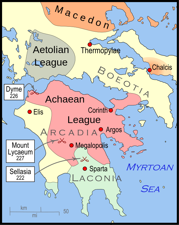
English: Mainland Greece during the time of the Cleomenean War, ca. 228 BCE |
| Data | |
| Origem | Obra do próprio |
| Autor | MapMaster |
| Outras versões |
[]
|


-pt.svg)


References
The map itself was built using File:Greece map blank.svg, adding the now-drained Lake Copais. Towns were placed using geographic coordinates.
The borders of the various political entities were taken from several sources:
- Chamoux, François (2002) Hellenistic civilization, Wiley-Blackwell, ISBN 9780631222422, p. 206, for the Achaean League. I did not use this for the Aetolian League, since this map shows the later and larger borders of the Aetolian League, after the Cleomenean War.
- Gabbert, Janice J. (1997) Antigonus II Gonatas: a political biography, Routledge, ISBN 9780415018999 , p. 33, for the area under the control of Macedon.
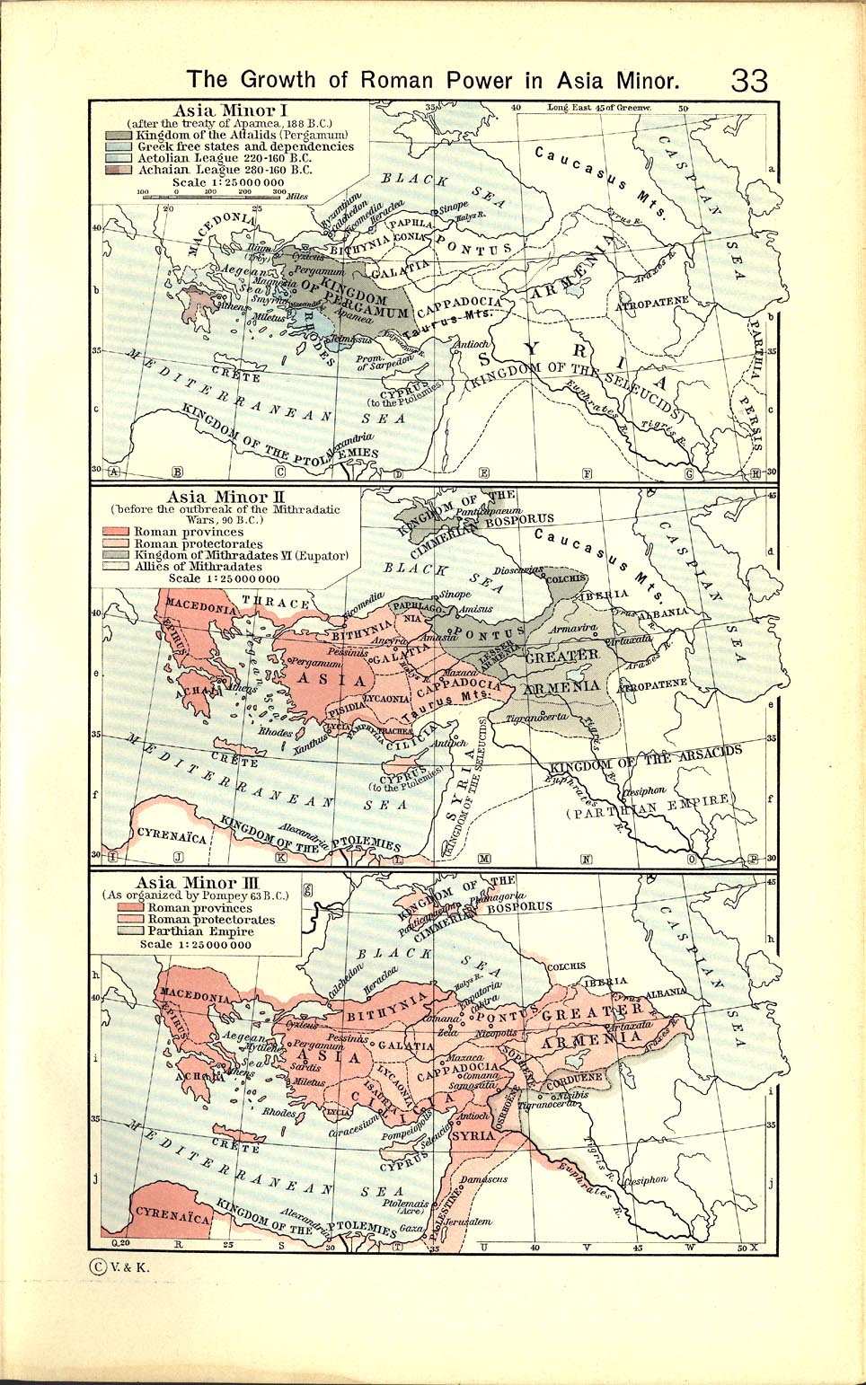
- Shepherd, William (1911) "The Growth of Roman Power in Asia Minor", Historical Atlas, Henry Holt and Company. p. 33, was used as the primary reference for the Aetolian League.
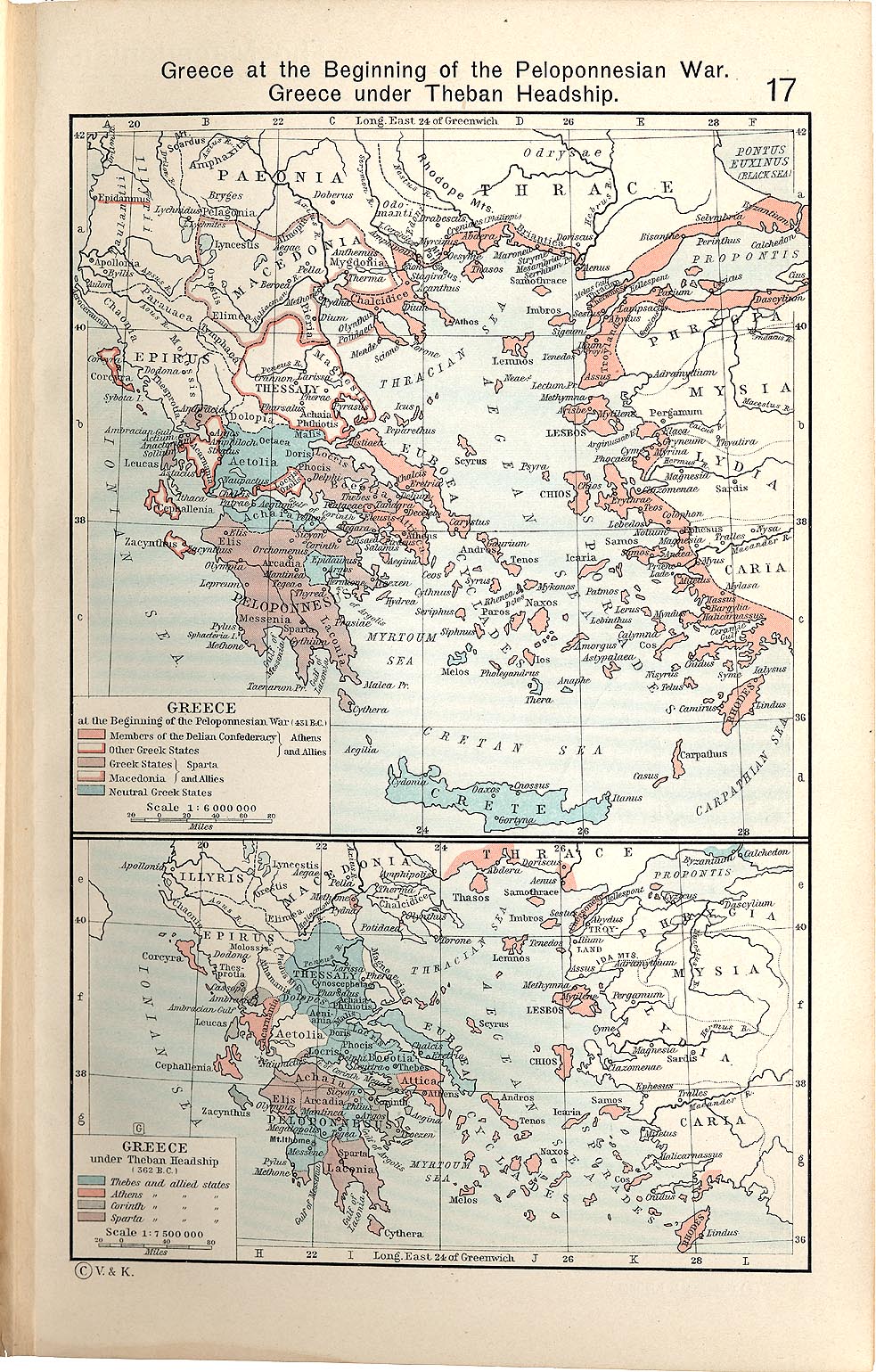
- Shepherd, William (1911) "Greece under Theban Headship", Historical Atlas, Henry Holt and Company. p. 17, was used as the primary reference for the Spartan borders. When there was a conflict with the Chamoux map, I used the Chamoux map.
Any additional information on borders and areas under control would be very welcome.
Similar maps

Licenciamento
Eu, titular dos direitos de autor desta obra, publico-a com a seguinte licença:
A utilização deste ficheiro é regulada nos termos da licença Creative Commons - Atribuição-CompartilhaIgual 3.0 Não Adaptada.
- Pode:
- partilhar – copiar, distribuir e transmitir a obra
- recombinar – criar obras derivadas
- De acordo com as seguintes condições:
- atribuição – Tem de fazer a devida atribuição da autoria, fornecer uma hiperligação para a licença e indicar se foram feitas alterações. Pode fazê-lo de qualquer forma razoável, mas não de forma a sugerir que o licenciador o apoia ou subscreve o seu uso da obra.
- partilha nos termos da mesma licença – Se remisturar, transformar ou ampliar o conteúdo, tem de distribuir as suas contribuições com a mesma licença ou uma licença compatível com a original.
Histórico do ficheiro
Clique uma data e hora para ver o ficheiro tal como ele se encontrava nessa altura.
| Data e hora | Miniatura | Dimensões | Utilizador | Comentário | |
|---|---|---|---|---|---|
| atual | 04h57min de 12 de janeiro de 2010 | | 431 × 542 (982 kB) | MapMaster | {{Information |Description={{en|1=A map of Greece during the Cleomenean War}} |Source={{own}} |Author=MapMaster |Date=11 January 2010 |Permission= |other_versions= }} Category:Maps of the history of Greece |
Utilização local do ficheiro
Não há nenhuma página que use este ficheiro.
Utilização global do ficheiro
As seguintes wikis usam este ficheiro:
- ar.wikipedia.org
- bg.wikipedia.org
- ca.wikipedia.org
- el.wikipedia.org
- en.wikipedia.org
- et.wikipedia.org
- he.wikipedia.org
- it.wikipedia.org
- ja.wikipedia.org
- ko.wikipedia.org
- nl.wikipedia.org
- sh.wikipedia.org
- tr.wikipedia.org
- uk.wikipedia.org
- vi.wikipedia.org
- www.wikidata.org
- zh.wikipedia.org