Ficheiro:Map of Banstead 1841 Lambert.png

Imagem numa resolução maior (3 231 × 4 642 píxeis, tamanho: 7,12 MB, tipo MIME: image/png)
|
|
Esta imagem provém do Wikimedia Commons, um acervo de conteúdo livre da Wikimedia Foundation que pode ser utilizado por outros projetos.
|
Descrição do ficheiro
| Descrição |
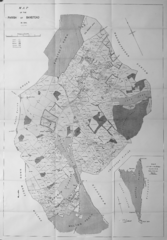
English: Map of Banstead in 1841 from Lambert, H.C.M. 1912 History of Banstead in Surrey; the book provides annotations for some of the place names, many of which have given rise to modern street names. Two scans had to be stitched together, and the original was not quite flat, so there is slight distortion. |
||||
| Data | |||||
| Origem | https://openlibrary.org/books/OL23304266M/History_of_Banstead_in_Surrey. | ||||
| Autor | Lambert, H.C.M. | ||||
| Permissão (Reutilizar este ficheiro) |
|
||||
Licenciamento
|
Esta obra está no domínio público no seu país de origem e noutros países e áreas onde o período de proteção dos direitos de autor é igual ou inferior à vida do autor mais 70 anos. Esta obra está no domínio público nos Estados Unidos porque foi publicada (ou registada no U.S. Copyright Office) antes de 1 de janeiro de 1929. | |
| Este ficheiro foi considerado livre de restrições conhecidas devidas a direitos de autor, incluindo todos os direitos conexos. | |
Histórico do ficheiro
Clique uma data e hora para ver o ficheiro tal como ele se encontrava nessa altura.
| Data e hora | Miniatura | Dimensões | Utilizador | Comentário | |
|---|---|---|---|---|---|
| atual | 18h29min de 7 de março de 2015 | | 3 231 × 4 642 (7,12 MB) | Jmchutchinson | {{Information |Description ={{en|1=Map of Banstead in 1841 from Lambert, H.C.M. 1912 ''History of Banstead in Surrey''; the book provides annotations for some of the place names, many of which have given rise to modern street names. Two scans had to... |
Utilização local do ficheiro
A seguinte página usa este ficheiro:
Utilização global do ficheiro
As seguintes wikis usam este ficheiro:
- en.wikipedia.org