Ficheiro:Map of British North Borneo, yellow area covered by the Philippine claim.PNG
Map_of_British_North_Borneo,_yellow_area_covered_by_the_Philippine_claim.PNG (570 × 438 píxeis, tamanho: 552 kB, tipo MIME: image/png)
|
|
Esta imagem provém do Wikimedia Commons, um acervo de conteúdo livre da Wikimedia Foundation que pode ser utilizado por outros projetos.
|
| Descrição |
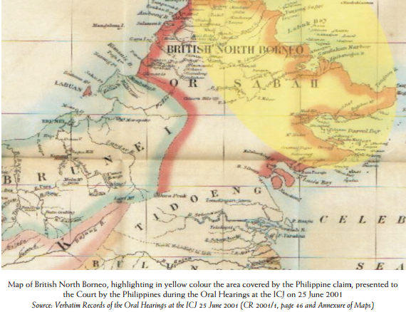
English: Map of British North Borneo, highlighting in yellow colour the area covered by the Philippine claim, presented to the Court by the Philippines during the Oral Hearings at the ICJ on 25 June 2001 Source: Verbatim Records of the Oral Hearings at the ICJ 25 June 2001 (CR 2001/1, page 46 and Annexure of Maps) |
|||||||
| Data | Map since 18th century (Presented by the Philippines to ICJ on 25 June 2001) | |||||||
| Origem | Map of British North Borneo, highlighting in yellow colour the area covered by the Philippine claim, presented to the Court by the Philippines during the Oral Hearings at the ICJ on 25 June 2001 | |||||||
| Autor | Desconhecido | |||||||
| Permissão (Reutilizar este ficheiro) |
|
|||||||

Histórico do ficheiro
Clique uma data e hora para ver o ficheiro tal como ele se encontrava nessa altura.
| Data e hora | Miniatura | Dimensões | Utilizador | Comentário | |
|---|---|---|---|---|---|
| atual | 14h50min de 16 de maio de 2014 | | 570 × 438 (552 kB) | Muffin Wizard | {{Information |Description ={{en|1=Map of British North Borneo, highlighting in yellow colour the area covered by the Philippine claim, presented to the Court by the Philippines during the Oral Hearings at the ICJ on 25 June 2001 Source: Verbatim Re... |
Utilização local do ficheiro
A seguinte página usa este ficheiro:
Utilização global do ficheiro
As seguintes wikis usam este ficheiro:
- en.wikipedia.org