Ficheiro:Map of the shelling of Yeonpyeong.svg

Dimensões desta antevisão em PNG do ficheiro SVG: 800 × 573 píxeis Outras resoluções: 320 × 229 píxeis | 640 × 458 píxeis | 1 024 × 733 píxeis | 1 280 × 916 píxeis | 2 560 × 1 833 píxeis | 912 × 653 píxeis.
Imagem numa resolução maior (ficheiro SVG, de 912 × 653 píxeis, tamanho: 338 kB)
|
|
Esta imagem provém do Wikimedia Commons, um acervo de conteúdo livre da Wikimedia Foundation que pode ser utilizado por outros projetos.
|
Descrição do ficheiro
| Descrição |
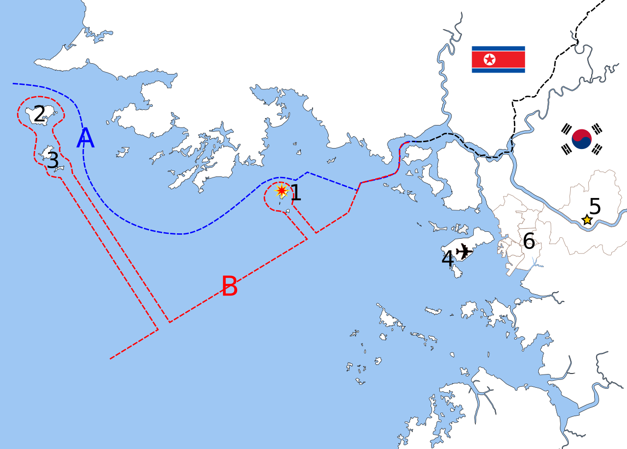
English: Map of the shelling of Yeonpyeong, language neutral version.
Polski: Mapa ostrzału wyspy Yeonpyeong.
中文(简体):延坪岛炮击事件地图,语言中性版本。
中文(繁體):延坪島炮擊事件地圖,語言中性版本。
Deutsch: Karte der Bombardierung von Yeonpyeong, sprachneutrale Version.
Français : Carte du bombardement de Yeonpyeong, version langue-neutral
Nederlands: Kaart van de granaataanval op Yeonpyeong, taalneutrale versie
|
| Data | |
| Origem | Based on File:Inchon islands 2.svg (by Amble) and File:朝韩争议区(延坪岛附近).svg (by 玖巧仔). Modified and converted to language neutral version by Tomchen1989. Flags are from File:Flag of South Korea.svg and File:Flag of North Korea.svg which are in the public domain. The Northern Limit Line and the Military Demarcation Line are according to Xinhua and NYTimes. |
| Autor | See above |
| Outras versões |
|

Licenciamento
A utilização deste ficheiro é regulada nos termos da licença Creative Commons - Atribuição-CompartilhaIgual 3.0 Não Adaptada.
Atribuição: Amble, 玖巧仔 and Tomchen1989
- Pode:
- partilhar – copiar, distribuir e transmitir a obra
- recombinar – criar obras derivadas
- De acordo com as seguintes condições:
- atribuição – Tem de fazer a devida atribuição da autoria, fornecer uma hiperligação para a licença e indicar se foram feitas alterações. Pode fazê-lo de qualquer forma razoável, mas não de forma a sugerir que o licenciador o apoia ou subscreve o seu uso da obra.
- partilha nos termos da mesma licença – Se remisturar, transformar ou ampliar o conteúdo, tem de distribuir as suas contribuições com a mesma licença ou uma licença compatível com a original.
Histórico do ficheiro
Clique uma data e hora para ver o ficheiro tal como ele se encontrava nessa altura.
| Data e hora | Miniatura | Dimensões | Utilizador | Comentário | |
|---|---|---|---|---|---|
| atual | 10h26min de 24 de novembro de 2010 | | 912 × 653 (338 kB) | Tomchen1989 | updated |
| 03h54min de 24 de novembro de 2010 |  | 912 × 653 (337 kB) | Tomchen1989 | {{Information |Description={{en|1=Map of the shelling of Yeonpyeong, language neutral version}} |Source=Based on File:Inchon islands 2.svg (by User:Amble) and File:朝韩争议区(延坪岛附近).svg (by [ |
Utilização local do ficheiro
As seguintes 2 páginas usam este ficheiro:
Utilização global do ficheiro
As seguintes wikis usam este ficheiro:
- en.wikipedia.org
- es.wikipedia.org
- fi.wikipedia.org
- hu.wikipedia.org
- ja.wikipedia.org
- ko.wikipedia.org
- pl.wikipedia.org