Ficheiro:Mt. Pico De Loro Monolith.jpg

Imagem numa resolução maior(1 741 × 1 243 píxeis, tamanho: 376 kB, tipo MIME: image/jpeg)

Descrição do ficheiro

Descrição
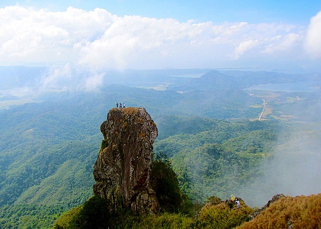
English: At the summit of Mt. Pico De Loro is a monolith. Also known as the Parrot's beak. It is a 60-meter natural rock formation often scaled by rock climbers. Shot by Schadow1 Expeditions during its mapping expedition to Pico De Loro of 2013.
Data
Origem Obra do próprio
Autor Ervin Malicdem
Permissão
(Reutilizar este ficheiro)
Eu, titular dos direitos de autor desta obra, publico-a com as seguintes licenças:
GNU head É concedida permissão para copiar, distribuir e/ou modificar este documento nos termos da Licença de Documentação Livre GNU, versão 1.2 ou qualquer versão posterior publicada pela Free Software Foundation; sem Secções Invariantes, sem textos de Capa e sem textos de Contra-Capa. É incluída uma cópia da licença na secção intitulada GNU Free Documentation License.
w:pt:Creative Commons
atribuição partilha nos termos da mesma licença
A utilização deste ficheiro é regulada nos termos da licença Creative Commons Atribuição-CompartilhaIgual 4.0 Internacional.
Pode:
  • partilhar – copiar, distribuir e transmitir a obra
  • recombinar – criar obras derivadas
De acordo com as seguintes condições:
  • atribuição – Tem de fazer a devida atribuição da autoria, fornecer uma hiperligação para a licença e indicar se foram feitas alterações. Pode fazê-lo de qualquer forma razoável, mas não de forma a sugerir que o licenciador o apoia ou subscreve o seu uso da obra.
  • partilha nos termos da mesma licença – Se remisturar, transformar ou ampliar o conteúdo, tem de distribuir as suas contribuições com a mesma licença ou uma licença compatível com a original.
Pode escolher a licença que quiser.
Creative Commons Share-alike Attribution If you choose to use this work under the Creative Commons license stated above, the author, Ervin Malicdem (schadow1), would like you to attribute the work to him (among other requirements such as indicating that the work is licensed under the Creative Commons) with the following text or similar:
© Ervin Malicdem, 2013.

His name should be a link to his Wikimedia Commons userpage. If a link is not possible, then the url should be placed in parentheses after the name. If the work has been substantially altered by other people (see the File history section below), then this particular attribution requirement is waived, which means you can attribute the work in any reasonable manner.


This attribution requirement is provided pursuant to the Creative Commons Attribution-ShareAlike mechanism where "you must attribute the work in the manner specified by the author or licensor (but not in any way that suggests that they endorse you or your use of the work.) And if you remix the work, it must be distributed with the same license." (See "Attribution" in the Creative Commons website.)
Localização da câmara 14° 12′ 51,27″ N, 120° 38′ 47,05″ E  Heading=201° Kartographer map based on OpenStreetMap.Esta e outras imagens nas suas localizações em: OpenStreetMapinfo

Initially published at Schadow1 Expeditions article available at http://www.s1expeditions.com/2013/01/pico-de-loro-summit-664masl-part-2.html

Legendas

Adicione uma explicação de uma linha do que este ficheiro representa

Elementos retratados neste ficheiro

retrata

14°12'51.274800457"N, 120°38'47.047200000"E

0,003125 segundo

5 milímetro

image/jpeg

Histórico do ficheiro

Clique uma data e hora para ver o ficheiro tal como ele se encontrava nessa altura.

Data e horaMiniaturaDimensõesUtilizadorComentário
atual14h05min de 17 de janeiro de 2015Miniatura da versão das 14h05min de 17 de janeiro de 20151 741 × 1 243 (376 kB)Schadow1change to generic
12h46min de 17 de janeiro de 2015Miniatura da versão das 12h46min de 17 de janeiro de 20151 920 × 1 371 (487 kB)Schadow1User created page with UploadWizard

A seguinte página usa este ficheiro:

Utilização global do ficheiro

Metadados