Ficheiro:North West England counties 2009 map.svg

Dimensões desta antevisão em PNG do ficheiro SVG: 300 × 599 píxeis Outras resoluções: 120 × 240 píxeis | 240 × 480 píxeis | 385 × 768 píxeis | 513 × 1 024 píxeis | 1 026 × 2 048 píxeis | 674 × 1 345 píxeis.
Imagem numa resolução maior (ficheiro SVG, de 674 × 1 345 píxeis, tamanho: 1,39 MB)
|
|
Esta imagem provém do Wikimedia Commons, um acervo de conteúdo livre da Wikimedia Foundation que pode ser utilizado por outros projetos.
|
Descrição do ficheiro
| Descrição |
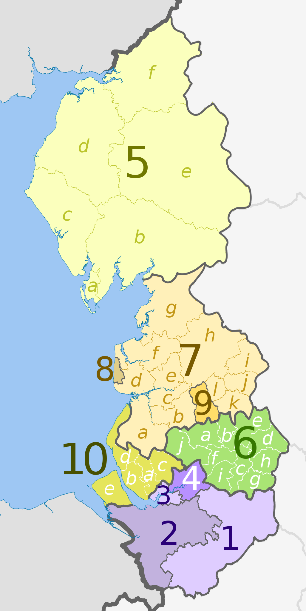
English: Map of the North West England region, showing its counties and administrative districts until 31 March 2023. The county colours are the same as those in File:English metropolitan and non-metropolitan counties 2009.svg.
For counties since 1 April 2023, see File:North West England counties 2023 map.svg. Equirectangular map projection on WGS 84 datum, with N/S stretched 170% Geographic limits:
|
| Data | (UTC) |
| Origem |
Este ficheiro foi derivado de: |
| Autor |
|
| Outras versões | File:North West England counties 2023 map.svg – version since 1 April 2023 |


| Map | Ceremonial county | County/Unitary | Metropolitan/non-metropolitan districts |
|---|---|---|---|
 |
Cheshire | 1. Cheshire East U.A. | |
| 2. Cheshire West and Chester U.A. | |||
| 3. Halton U.A. | |||
| 4. Warrington U.A. | |||
| 5. Cumbria † | a) Barrow-in-Furness, b) South Lakeland, c) Copeland, d) Allerdale, e) Eden, f) Carlisle | ||
| 6. Greater Manchester * | a) Bolton, b) Bury, c) Manchester, d) Oldham, e) Rochdale, f) Salford, g) Stockport, h) Tameside, i) Trafford, j) Wigan | ||
| Lancashire | 7. Lancashire † | a) West Lancashire, b) Chorley, c) South Ribble, d) Fylde, e) Preston, f) Wyre, g) Lancaster, h) Ribble Valley, i) Pendle, j) Burnley, k) Rossendale, l) Hyndburn | |
| 8. Blackpool U.A. | |||
| 9. Blackburn with Darwen U.A. | |||
| 10. Merseyside * | a) Knowsley, b) Liverpool, c) St. Helens, d) Sefton, e) Wirral | ||
Key: †shire county | *metropolitan county
Licenciamento
A utilização deste ficheiro é regulada nos termos da licença Creative Commons - Atribuição-CompartilhaIgual 3.0 Não Adaptada.
Atribuição: Dr Greg and Nilfanion. Contains Ordnance Survey data © Crown copyright and database right 2011
- Pode:
- partilhar – copiar, distribuir e transmitir a obra
- recombinar – criar obras derivadas
- De acordo com as seguintes condições:
- atribuição – Tem de fazer a devida atribuição da autoria, fornecer uma hiperligação para a licença e indicar se foram feitas alterações. Pode fazê-lo de qualquer forma razoável, mas não de forma a sugerir que o licenciador o apoia ou subscreve o seu uso da obra.
- partilha nos termos da mesma licença – Se remisturar, transformar ou ampliar o conteúdo, tem de distribuir as suas contribuições com a mesma licença ou uma licença compatível com a original.
Registo de carregamento original
This image is a derivative work of the following images:
- File:North_West_England_districts_2011_map.svg licensed with Cc-by-sa-3.0, GFDL
- 2011-05-01T19:03:10Z Nilfanion 674x1345 (1403071 Bytes) == Summary == {{Information |Description=Map of the [[w:North West England|North West England]] region showing the administrative districts. Equirectangular map projection on WGS 84 datum, with N/S stretched 170% Geographic
- File:English_ceremonial_counties_2010.svg licensed with Cc-by-sa-3.0, GFDL
- 2010-11-23T16:39:55Z Nilfanion 1108x1345 (308868 Bytes) thicker lines
- 2010-11-23T16:20:19Z Nilfanion 1108x1345 (301520 Bytes) tweaks
- 2010-10-26T20:34:20Z Nilfanion 817x990 (1391832 Bytes) {{Information |Description=Map showing the [[w:ceremonial counties of England]] including the City of London, in 2010. Equirectangular map projection on WGS 84 datum, with N/S stretched 170% Geographic limits: *West: 6.75W
Carregada com derivativeFX
Histórico do ficheiro
Clique uma data e hora para ver o ficheiro tal como ele se encontrava nessa altura.
| Data e hora | Miniatura | Dimensões | Utilizador | Comentário | |
|---|---|---|---|---|---|
| atual | 20h08min de 5 de maio de 2012 | | 674 × 1 345 (1,39 MB) | Dr Greg | lighten black boundary line |
| 23h16min de 1 de maio de 2012 |  | 674 × 1 345 (1,39 MB) | Dr Greg | == {{int:filedesc}} == {{Information |Description={{en|Map of the North West England region, showing its counties and administrative districts. The county colours are the same as those in [[:File:English metropolitan and non-me... |
Utilização local do ficheiro
A seguinte página usa este ficheiro:
Utilização global do ficheiro
As seguintes wikis usam este ficheiro:
- ar.wikipedia.org
- fa.wikipedia.org
- frr.wikipedia.org
- hr.wikipedia.org
- hu.wikipedia.org
- mr.wikipedia.org
- no.wikipedia.org
- pl.wikipedia.org
- pnb.wikipedia.org
- ru.wikipedia.org
- sh.wikipedia.org
- th.wikipedia.org
- ur.wikipedia.org
- vi.wikipedia.org
- vls.wikipedia.org
- zh-yue.wikipedia.org