Ficheiro:Okavango Swamp, Botswana.JPG
Dimensões desta antevisão: 800 × 531 píxeis. Outras resoluções: 320 × 213 píxeis | 640 × 425 píxeis | 1 024 × 680 píxeis | 1 280 × 850 píxeis | 2 560 × 1 700 píxeis | 4 288 × 2 848 píxeis.
Imagem numa resolução maior (4 288 × 2 848 píxeis, tamanho: 13,86 MB, tipo MIME: image/jpeg)
|
|
Esta imagem provém do Wikimedia Commons, um acervo de conteúdo livre da Wikimedia Foundation que pode ser utilizado por outros projetos.
|
Descrição do ficheiro
| Descrição |
Afrikaans: Hierdie ruimtevaarderfoto met 'n kort fokusafstand toon die hele Okawangodelta, die groot moerasland van suider-Afrika wat bekend staan as die "juweel van die Kalahariwoestyn." Die donkergroen bebosde vloedvlakte is sowat 10 kilometer breed waar dit die beeld binnekom. Die Okawangowaters vloei dan 'n verskuiwingsbekken binne, waarmee die rivier uitdy om die vleiland te vorm. Die wydte van die verskuiwing bepaal ook die afmetings van die delta, naamlik 150 kilometer van die bopunt tot by die stroomstuwing (regs op beeld). Die verskuiwingapeks is moeilik onderskeibaar, maar twee verskuiwings definieer die stroomaflimiet. Hierdie verskuiwings verskyn as reglynige stroomkanale en plantegroeipatrone ortogonaal met die suidoostelike kanale (aan die beeldsentrum). Die groenigheid van weliger savanneplantegroei in die noorde wyk voor die bruin en oop doringbossavanne in die suide, wat ooreenstem met die reënvalpatroon van hoër neerslag na die noorde en die laer neerslag van sentraal-Botswana. Meer subtiele onderskeide val ook op: die arms van die delta bestaan uit die langwerpige bladwisselende bosstroke en permanente rivierbos (donkergroen) teenoor grasveld en ander savanneplantegroei (liggroen) op vloedvlaktes. Reglynige duine, opgebou deur langdurige oostewinde tydens droër klimaatstoestande, verskyn links as aaneenlopende lyne. Slegs 2 tot 5 persent van die water wat die Okawangodelta binnedring, vloei weer daaruit. (Vergelyk die klein Botetirivier, regs, waar water uit die delta vloei, met die wye Okawangovloedvlakte links op beeld.) In natter jare bereik sommige water die Ngamimeer (onder regs), waar dit verdamp. Nog 'n kenmerk van die beeld getuig van moderne globalisering. Die geboë lyn in die suidwestelike deel van die delta is die suidelike buffelheining, 'n uitgebreide installasie wat buffeltroppe in die vleiland skei van beeste wat in die digter bevolkte gebiede rondom die delta aangehou word (onder en regs op beeld). Die heining verdeel ligter en donkerder grasveld wat daarop dui dat die aanwas van plante sterker (groener) is in die bevolke suidweste as binne die delta.
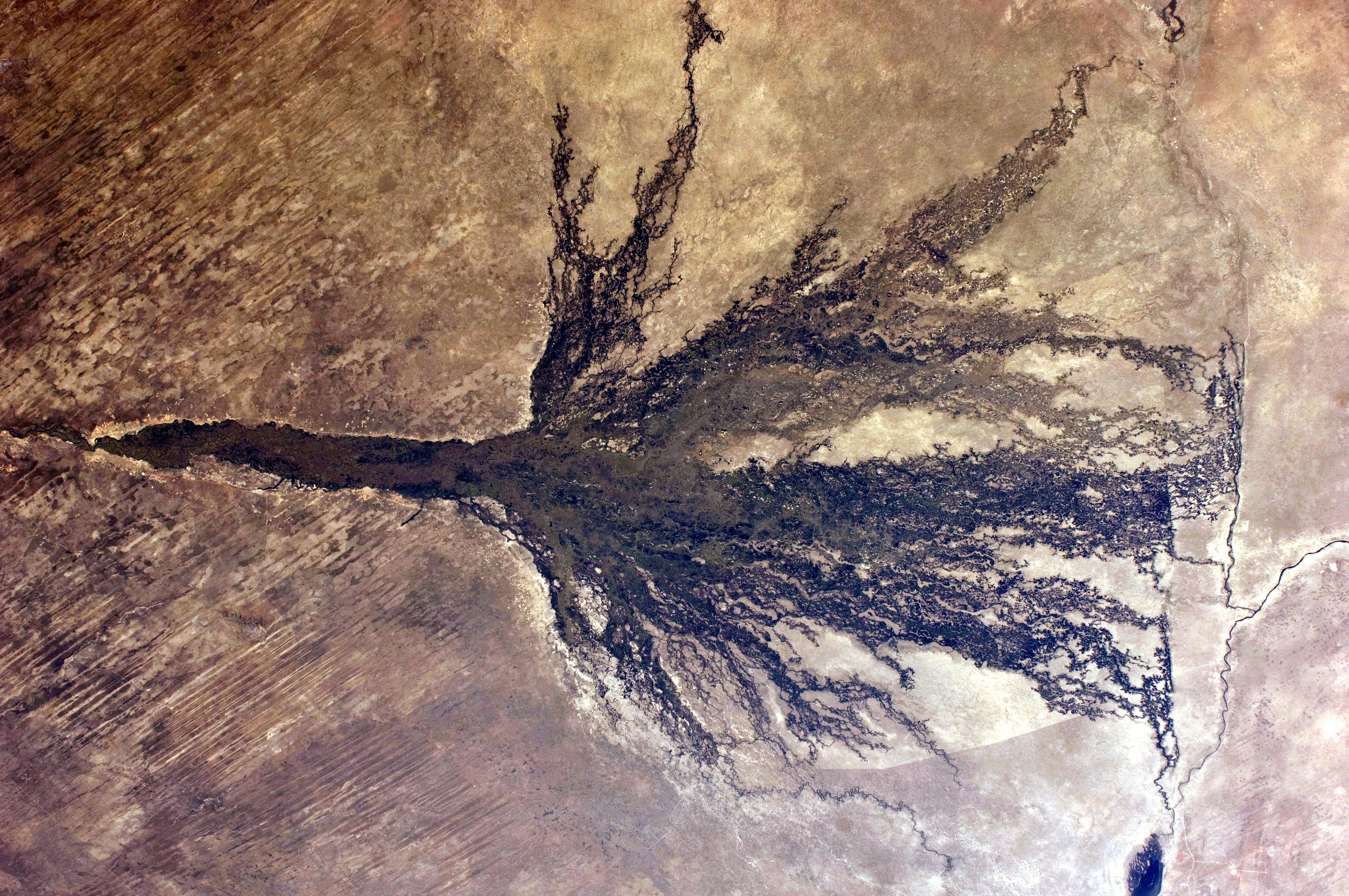
English: This short focal-length astronaut photograph shows the entire Okavango “delta,” a swampland known in southern Africa as the “Jewel of the Kalahari Desert.” The dark-green forested floodplain is about 10 kilometres wide where it enters the view (image left). The Okavango then enters a rift basin, which allows the river to spread out and form the wetland. The width of the rift determines the dimensions of the delta—150 kilometres from the apex to the downstream margin (image right). The apex fault is difficult to discern, but two fault lines define the downstream margin; the faults appear as linear stream channels and vegetation patterns oriented at right angles to the southeast-trending channels at image centre. The greens of denser savanna vegetation in the north give way to browns of the open “thornscrub” savanna to the south, matching the precipitation patterns of higher rainfall in the north and less rainfall in central Botswana. More subtle distinctions also appear: the arms of the delta include tall, permanent riverine forest and seasonal forest (dark green), with grasses and other savanna vegetation (light green) on floodplains. Linear dunes, built up by constant winds from the east during drier climates, appear as straight lines at image left. Only 2 to 5 percent of the water that enters the Okavango delta flows out of it. (Compare the small Boteti River (image right), where water flows out of the delta, with the wide Okavango floodplain at image left.) In wetter years, some water reaches Lake Ngami (lower right), where it evaporates. Another feature in the image also suggests modern globalization. The curved line in the southwest part of the delta is the Southern Buffalo Fence, a major installation that separates wild buffalo herds within the wetland from cattle herds, which occupy more populated areas surrounding the delta (image bottom, image right). The fence divides lighter-toned and darker grassland; suggesting that vegetation growth is stronger (greener) on the populated southwest side than within the delta. |
| Data | |
| Origem | NASA Earth Observatory |
| Autor | ISS Expedition 28 crew |
| Localização da câmara | | Esta e outras imagens nas suas localizações em: OpenStreetMap |
|---|
Este(a) imagem ou vídeo foi catalogado(a) por Centro Espacial Johnson dos Estados Unidos da América para a Administração Nacional da Aeronáutica e do Espaço (NASA), sobre o código ID: ISS028-E-6830. Esta marcação não indica o estado dos direitos de autor da obra aqui mostrada. Continua a ser necessária uma marcação normal de direitos de autor. Veja Commons:Licenciamento para mais informações. Outras línguas:
|
Image acquired with a Nikon D2Xs digital camera using a 28 mm lens, and is provided by the ISS Crew Earth Observations experiment and Image Science & Analysis Laboratory, Johnson Space Center.
Licenciamento
| Este ficheiro está no domínio público nos Estados Unidos porque foi criado exclusivamente pela NASA. As orientações sobre o direito de autor da NASA são que «as obras da NASA não têm os direitos de autor protegidos salvo indicação em contrário». Veja Template:PD-USGov, as orientações sobre o direito de autor da NASA ou as normas de uso de imagens do Laboratório de Propulsão a Jato (Jet Propulsion Lab, JPL). | ||
 |
Avisos:
|
| Anotações | Esta imagem está anotada: Ver as anotações na wiki Commons |
Histórico do ficheiro
Clique uma data e hora para ver o ficheiro tal como ele se encontrava nessa altura.
| Data e hora | Miniatura | Dimensões | Utilizador | Comentário | |
|---|---|---|---|---|---|
| atual | 13h43min de 27 de junho de 2011 | | 4 288 × 2 848 (13,86 MB) | Originalwana | {{Information |Description ={{en|1=This short focal-length astronaut photograph shows the entire Okavango “delta,” a swampland known in southern Africa as the “Jewel of the Kalahari Desert.” The dark-green for |
Utilização local do ficheiro
A seguinte página usa este ficheiro:
Utilização global do ficheiro
As seguintes wikis usam este ficheiro:
- es.wikipedia.org
- fa.wikipedia.org
- gl.wikipedia.org
- hr.wikipedia.org
- hu.wikipedia.org
- pnb.wikipedia.org
- sl.wikipedia.org
- ta.wikipedia.org