Ficheiro:PIA00215-cropped.jpg
Dimensões desta antevisão: 766 × 599 píxeis. Outras resoluções: 307 × 240 píxeis | 614 × 480 píxeis | 869 × 680 píxeis.
Imagem numa resolução maior (869 × 680 píxeis, tamanho: 206 kB, tipo MIME: image/jpeg)
|
|
Esta imagem provém do Wikimedia Commons, um acervo de conteúdo livre da Wikimedia Foundation que pode ser utilizado por outros projetos.
|
Descrição do ficheiro
| Descrição |
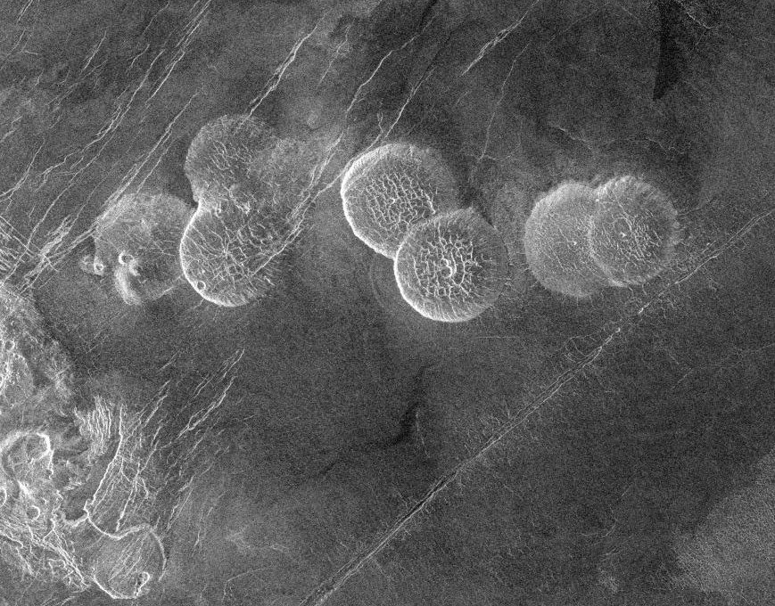
English: The eastern edge of Alpha Regio is shown in this image centered at 30 degrees south latitude and 11.8 degrees east longitude (longitude on Venus is measured from 0 degrees to 360 degrees east). Seven circular, dome-like hills, averaging 25 kilometers (15 miles) in diameter with maximum heights of 750 meters (2,475 feet) dominate the scene. These features are interpreted as very thick lava flows that came from an opening on the relatively level ground, which allowed the lava to flow in an even pattern outward from the opening. The complex fractures on top of the domes suggest that if the domes were created by lava flows, a cooled outer layer formed and then further lava flowing in the interior stretched the surface. The domes may be similar to volcanic domes on Earth. Another interpretation is that the domes are the result of molten rock or magma in the interior that pushed the surface layer upward. The near-surface magma then withdrew to deeper levels, causing the collapse and fracturing of the dome surface. The bright margins possibly indicate the presence of rock debris on the slopes of the domes. Some of the fractures on the plains cut through the domes, while others appear to be covered by the domes. This indicates that active processes pre date and post date the dome-like hills. The prominent black area in the northeast corner of the image is a data gap. North is at the top of the image. Mosaic of Magellan radar images. The domes are called Seoritsu Farra (a map) |
| Data | |
| Origem | http://photojournal.jpl.nasa.gov/catalog/PIA00215 |
| Autor | NASA/JPL |
| Outras versões | file:Alpha Regio.jpg |
Este(a) imagem ou vídeo foi catalogado(a) por Laboratório de Propulsão a Jato dos Estados Unidos da América para a Administração Nacional da Aeronáutica e do Espaço (NASA), sobre o código ID: PIA00215. Esta marcação não indica o estado dos direitos de autor da obra aqui mostrada. Continua a ser necessária uma marcação normal de direitos de autor. Veja Commons:Licenciamento para mais informações. Outras línguas:
|
| Este ficheiro está no domínio público nos Estados Unidos porque foi criado exclusivamente pela NASA. As orientações sobre o direito de autor da NASA são que «as obras da NASA não têm os direitos de autor protegidos salvo indicação em contrário». Veja Template:PD-USGov, as orientações sobre o direito de autor da NASA ou as normas de uso de imagens do Laboratório de Propulsão a Jato (Jet Propulsion Lab, JPL). | ||
 |
Avisos:
|
Histórico do ficheiro
Clique uma data e hora para ver o ficheiro tal como ele se encontrava nessa altura.
| Data e hora | Miniatura | Dimensões | Utilizador | Comentário | |
|---|---|---|---|---|---|
| atual | 19h20min de 27 de novembro de 2005 | | 869 × 680 (206 kB) | Dodo | PIA00215: Venus - Alpha Regio The eastern edge of Alpha Regio is shown in this image centered at 30 degrees south latitude and 11.8 degrees east longitude (longitude on Venus is measured from 0 degrees to 360 degrees east). Seven circular, dome-like hill |
Utilização local do ficheiro
A seguinte página usa este ficheiro:
Utilização global do ficheiro
As seguintes wikis usam este ficheiro:
- bat-smg.wikipedia.org
- ca.wikipedia.org
- de.wikipedia.org
- en.wikipedia.org
- es.wikipedia.org
- eu.wikipedia.org
- fr.wikipedia.org
- ja.wikipedia.org
- lt.wikipedia.org
- nds.wikipedia.org
- nn.wikipedia.org
- no.wikipedia.org
- sk.wikipedia.org
- zh.wikipedia.org