Ficheiro:Durian 2006-11-30 0500Z.jpg

Imagem numa resolução maior(5 800 × 7 600 píxeis, tamanho: 6,18 MB, tipo MIME: image/jpeg)

Descrição do ficheiro

Descrição

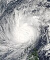
Super Typhoon Durian came ashore in the Philippines on November 30, 2006. According to BBC News Service, the typhoon was quite powerful, with sustained winds as high as 230 kilometers per hour (140 miles per hour). The storm’s name comes from a pungent fruit native to Southeast Asia. The twelfth typhoon of the season, Durian was projected as of November 30 to follow a track through the Philippines very similar to typhoons Xangsane, Cimaron, and Chebi, which all crossed the northern part of the island chain, bringing heavy rain and causing substantial damage. As with those other storms, Durian was expected to continue its eastward track and to cross the South China Sea, striking mainland Asia in Vietnam.

This photo-like image was acquired by the Moderate Resolution Imaging Spectroradiometer (MODIS) on the Aqua satellite on November 30, 2006, at 1:00 p.m. local time (5:00 UTC). At this time, Typhoon Durian was well over the island chain, with the cloud-filled eye over the land and the spiral arms of clouds covering almost the entire northern Philippines. Sustained winds were around 230 kilometers/hour (140 mph), according to the University of Hawaii’s Tropical Storm Information Center. These speeds were the peak strength projected for the storm, which was predicted to lose power as it traveled over the islands. Forecasts for its fate as it crossed the South China Sea were uncertain, but since the typhoon season was waning, sea surface temperatures in the South China Sea were not optimal for storm intensification, and forecasters were expecting the typhoon to gradually lose power well before coming ashore in southern Vietnam. 260 people were missing in typhoon durian and 200 body bags were needed...

The high-resolution image provided above is at MODIS’ full spatial resolution (level of detail) of 250 meters per pixel. The MODIS Rapid Response System provides this image at additional resolutions.
Data
Origem http://earthobservatory.nasa.gov/NaturalHazards/natural_hazards_v2.php3?img_id=13996
Autor NASA image by Jeff Schmaltz, MODIS Rapid Response Team, Goddard Space Flight Center
Permissão
(Reutilizar este ficheiro)
Public domain Este ficheiro está no domínio público nos Estados Unidos porque foi criado exclusivamente pela NASA. As orientações sobre o direito de autor da NASA são que «as obras da NASA não têm os direitos de autor protegidos salvo indicação em contrário». Veja Template:PD-USGov, as orientações sobre o direito de autor da NASA ou as normas de uso de imagens do Laboratório de Propulsão a Jato (Jet Propulsion Lab, JPL).
Avisos:
Outras versões Image:ST Durian 30 nov 2006 0500Z.jpg

Legendas

Adicione uma explicação de uma linha do que este ficheiro representa

Elementos retratados neste ficheiro

retrata

Histórico do ficheiro

Clique uma data e hora para ver o ficheiro tal como ele se encontrava nessa altura.

Data e horaMiniaturaDimensõesUtilizadorComentário
atual01h29min de 11 de dezembro de 2006Miniatura da versão das 01h29min de 11 de dezembro de 20065 800 × 7 600 (6,18 MB)Coredesat
01h25min de 11 de dezembro de 2006Miniatura da versão das 01h25min de 11 de dezembro de 20065 000 × 6 500 (11,94 MB)Coredesat
01h11min de 11 de dezembro de 2006Miniatura da versão das 01h11min de 11 de dezembro de 20065 000 × 6 000 (5,12 MB)Coredesat{{Information |Description=NASA MODIS image of Typhoon Durian over the Bicol Region of the Philippines, on November 30, 2006. |Source=[http://earthobservatory.nasa.gov/NaturalHazards/shownh.php3?img_id=13996 NASA Ea

Não há nenhuma página que use este ficheiro.

Utilização global do ficheiro

Metadados