Ficheiro:Sarajevo Grbavica.JPG
Imagem numa resolução maior (2 900 × 1 860 píxeis, tamanho: 3,9 MB, tipo MIME: image/jpeg)
|
|
Esta imagem provém do Wikimedia Commons, um acervo de conteúdo livre da Wikimedia Foundation que pode ser utilizado por outros projetos.
|
Descrição do ficheiro
| Descrição |
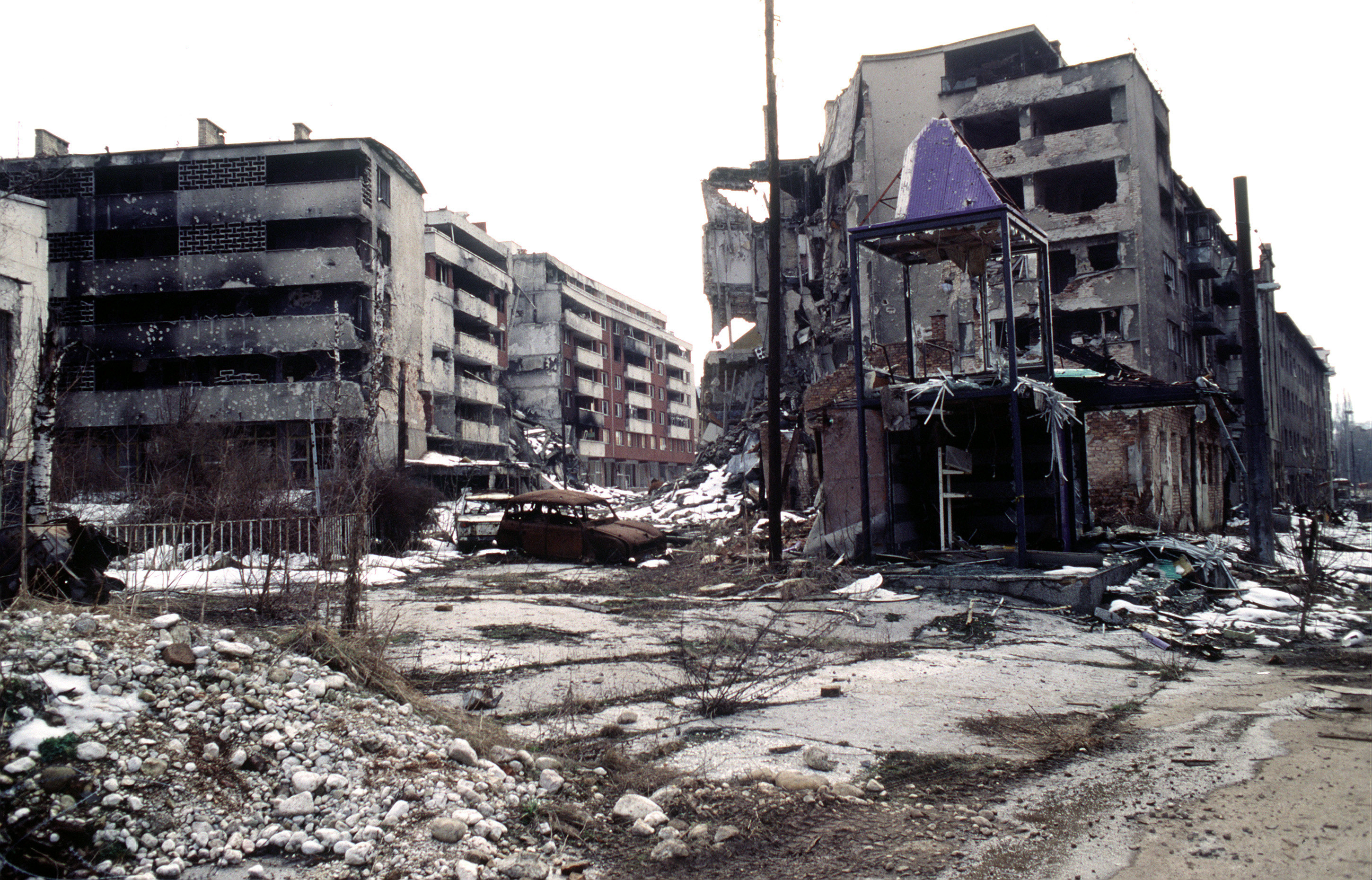
View of Grbavica, a neighbourhood of Sarajevo, approximately 4 months after the signing of the Dayton Peace Accord that officially ended the war in Bosnia. This particular scene shows the part of the neighbourhood located by the left bank of Miljacka river near Vrbanja bridge at the point where Zagrebačka Street and Beogradska Street (later renamed Emerika Bluma Street) meet. Throughout the war (1992-1995), Grbavica was held by the forces of Bosnian Serbs. In relation to the part of Grbavica shown in the photo, Bosnian Muslim (Bosniak) lines were right across on the Miljacka river's right bank. Due to its location in the crossfire between two sides, this part of Grbavica was exposed to constant fire and as a result suffered heavy structural damage. It was basically uninhabitable throughout the war - most of the apartments in the buildings seen in the photo were empty during the war as their occupants fled early on fearing for their safety. These ruins of the apartments and houses were among the last group to be turned over by the Bosnian Serbs to the Bosniaks (a.k.a. Bosnian Muslims) as required by the Dayton Peace Accord, which produced a lasting cease fire and permanent internal borders between two entities - Republika Srpska (Serb entity) and Federation of Bosnia-Herzegovina (Muslim-Croat entity). The white building whose small part (corner) can be seen along the photo's left edge housed the state-owned Unioninvest company before the war. In the years after the war ended, the partially devastated building was rebuilt and to this day houses the Office of the High Representative (OHR), an ad hoc international institution responsible for overseeing implementation of the Dayton Peace Accord (in essence, OHR is Bosnia's highest decision-making institutional body with broad powers). |
| Data | |
| Origem | www.dodmedia.osd.mil |
| Autor | LT. STACEY WYZKOWSKI |
| Permissão (Reutilizar este ficheiro) |
Public Domain (PD-USGov-Military) |
| Localização da câmara | | Esta e outras imagens nas suas localizações em: OpenStreetMap |
|---|
Licenciamento
Esta imagem é uma obra das Forças Armadas dos E.U.A ou funcionário do Departamento de Defesa dos Estados Unidos, tirada ou feita durante o exercício de funções oficiais de um funcionário. Como uma obra do governo federal dos E.U.A, a imagem é de domínio público..
Ver http://www.defenselink.mil/multimedia/about.html.
|
 |
Histórico do ficheiro
Clique uma data e hora para ver o ficheiro tal como ele se encontrava nessa altura.
| Data e hora | Miniatura | Dimensões | Utilizador | Comentário | |
|---|---|---|---|---|---|
| atual | 21h02min de 7 de abril de 2009 | | 2 900 × 1 860 (3,9 MB) | PRODUCER | contrast |
| 14h37min de 23 de março de 2008 |  | 2 900 × 1 860 (2,14 MB) | ¡0-8-15! | ||
| 22h00min de 20 de novembro de 2006 |  | 640 × 410 (60 kB) | Bunker~commonswiki | == Summary == {{Information |Description=Overall view of downtown Grbavica, a suburb of Sarajevo. These apartments and houses once occupied by Bosnia Serbs are the last group to be turned over to the Muslims as required by the recent Dayton Peace Accord w |
Utilização local do ficheiro
As seguintes 4 páginas usam este ficheiro:
Utilização global do ficheiro
As seguintes wikis usam este ficheiro:
- als.wikipedia.org
- ar.wikipedia.org
- azb.wikipedia.org
- be.wikipedia.org
- bg.wikipedia.org
- bs.wikipedia.org
- ca.wikipedia.org
- cs.wikipedia.org
- de.wikipedia.org
- el.wikipedia.org
- en.wikipedia.org
- en.wikinews.org
- en.wikiquote.org
- eo.wikipedia.org
- es.wikipedia.org
- eu.wikipedia.org
- fa.wikipedia.org
- fr.wikipedia.org
- he.wikipedia.org
- hr.wikipedia.org
- hu.wikipedia.org
- id.wikipedia.org
- it.wikipedia.org
Ver mais utilizações globais deste ficheiro.