Ficheiro:Southeast Indian Ocean cyclone tracks 1980-2005.jpg

Imagem numa resolução maior (3 000 × 2 700 píxeis, tamanho: 1,31 MB, tipo MIME: image/jpeg)
|
|
Esta imagem provém do Wikimedia Commons, um acervo de conteúdo livre da Wikimedia Foundation que pode ser utilizado por outros projetos.
|
Descrição do ficheiro
| Saffir-Simpson Hurricane Scale | ||||||
| TD | TS | 1 | 2 | 3 | 4 | 5 |
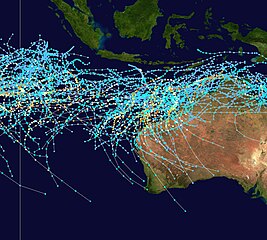
This map shows the tracks of all Tropical cyclones in the Southeast Indian Ocean from 1980 to 2005. 90° E longitude is marked on the map, this is the western boundary of the basin. The points show the locations of the storms at six-hourly intervals and use the color scheme shown above from Saffir-Simpson Hurricane Scale.
Licenciamento
Created using User:jdorje/Tracks by Nilfanion on 2007-02-19. Background image from Image:Whole world - land and oceans.jpg (NASA). The best track information is from the Joint Typhoon Warning Center.[1]
| Eu, titular dos direitos de autor desta obra, dedico-a ao domínio público, com aplicação em todo o mundo. Nalguns países isto pode não ser legalmente possível; se assim for: Concedo a todos o direito de usar esta obra para qualquer fim, sem quaisquer condições, a menos que tais condições sejam impostas por lei. |
Histórico do ficheiro
Clique uma data e hora para ver o ficheiro tal como ele se encontrava nessa altura.
| Data e hora | Miniatura | Dimensões | Utilizador | Comentário | |
|---|---|---|---|---|---|
| atual | 21h22min de 27 de fevereiro de 2007 | | 3 000 × 2 700 (1,31 MB) | Nilfanion | {|Description={|align="{{{align|right}}}" border="0" cellspacing="0" cellpadding="0" style="background:transparent;text-align:center" |- |colspan="7" nowrap="nowrap"| <small>Saffir-Simpson Hurricane Scale</small> |- |s |
Utilização local do ficheiro
As seguintes 2 páginas usam este ficheiro:
Utilização global do ficheiro
As seguintes wikis usam este ficheiro:
- en.wikipedia.org
- fr.wikipedia.org
- id.wikipedia.org
- ms.wikipedia.org
- ru.wikipedia.org
- th.wikipedia.org
- uk.wikipedia.org
- zh.wikipedia.org