|
| Amargosa River
|
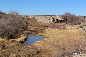
Amargosa River at Tecopa, California
|
| Origem do nome: Spanish word for "bitter"
|
|
|
| País
|
 Estados Unidos Estados Unidos
|
| Estados
|
Nevada, California
|
| County
|
Nye, San Bernardino, and Inyo
|
|
|
|
|
| Source
|
Pahute Mesa
|
| - lugar
|
Oasis Valley, Nye County, Nevada
|
| - elevation
|
1 208 ft (368 m) [1]
|
| - coordinates
|
37° 04′ 20″ N, 116° 41′ 19″ O [2]
|
| Mouth
|
Death Valley
|
| - location
|
Badwater Basin, Inyo County, California
|
| - elevation
|
−279 ft (−85 m)
|
| - coordinates
|
36° 14′ 37″ N, 116° 51′ 24″ O [2]
|
|
|
| Comprimento
|
185 mi (298 km) [2]
|
| Basin
|
5 500 sq mi (14 245 km2) [3]
|
| Discharge
|
for 0,2 milhas (0,3 km) west of Tecopa
|
| - average
|
3,8 cu ft/s (0,1 m3/s) [4]
|
| - max
|
10 600 cu ft/s (300,2 m3/s)
|
| - min
|
0 cu ft/s (0 m3/s)
|
|
|
|
|
|
| Amargosa River
|
Amargosa River at Tecopa, California
|
| Origem do nome: Spanish word for "bitter"
|
|
|
| País
|
 Estados Unidos Estados Unidos
|
| Estados
|
Nevada, California
|
| County
|
Nye, San Bernardino, and Inyo
|
|
|
|
|
| Source
|
Pahute Mesa
|
| - lugar
|
Oasis Valley, Nye County, Nevada
|
| - elevation
|
1 208 ft (368 m) [1]
|
| - coordinates
|
37° 04′ 20″ N, 116° 41′ 19″ O [2]
|
| Mouth
|
Death Valley
|
| - location
|
Badwater Basin, Inyo County, California
|
| - elevation
|
−279 ft (−85 m)
|
| - coordinates
|
36° 14′ 37″ N, 116° 51′ 24″ O [2]
|
|
|
| Comprimento
|
185 mi (298 km) [2]
|
| Basin
|
5 500 sq mi (14 245 km2) [3]
|
| Discharge
|
for 0,2 milhas (0,3 km) west of Tecopa
|
| - average
|
3,8 cu ft/s (0,1 m3/s) [4]
|
| - max
|
10 600 cu ft/s (300,2 m3/s)
|
| - min
|
0 cu ft/s (0 m3/s)
|
|
|
|
|
|


