Ficheiro:CircumnavigationByTrades.png
CircumnavigationByTrades.png (800 × 500 píxeis, tamanho: 287 kB, tipo MIME: image/png)
|
|
Esta imagem provém do Wikimedia Commons, um acervo de conteúdo livre da Wikimedia Foundation que pode ser utilizado por outros projetos.
|
Descrição do ficheiro
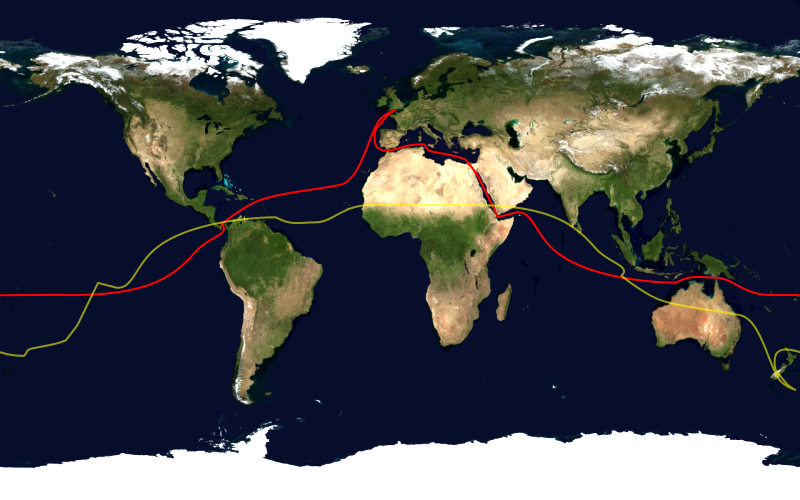
This image shows the route, in red, of a typical sailing circumnavigation of the world via the Panama Canal and Suez Canal, making use of the trade winds. Shown in yellow is the antipodean point of each point on the route; it can be seen that a boat following this route will pass through several points antipodean to each other, thus satisfying one definition of a circumnavigation.
This image was constructed from a public domain Visible Earth product of the Earth Observatory office of the United States government space agency NASA. It is based on a cylindrical equi-distant projection.
Licenciamento
| This image is in the public domain because it is a screenshot from NASA’s globe software World Wind using a public domain layer, such as Blue Marble, MODIS, Landsat, SRTM, USGS or GLOBE.
|
 |
Histórico do ficheiro
Clique uma data e hora para ver o ficheiro tal como ele se encontrava nessa altura.
| Data e hora | Miniatura | Dimensões | Utilizador | Comentário | |
|---|---|---|---|---|---|
| atual | 16h03min de 23 de janeiro de 2006 | | 800 × 500 (287 kB) | Johantheghost | This image shows the route, in red, of a typical sailing circumnavigation of the world via the Panama Canal and Suez Canal, making use of the [[Wikipe |
Utilização local do ficheiro
A seguinte página usa este ficheiro:
Utilização global do ficheiro
As seguintes wikis usam este ficheiro:
- ast.wikipedia.org
- da.wikipedia.org
- en.wikipedia.org
- eo.wikipedia.org
- es.wikipedia.org
- fi.wikipedia.org
- he.wikipedia.org
- ja.wikipedia.org
- ko.wikipedia.org
- la.wikipedia.org
- nl.wikipedia.org
- nn.wikipedia.org
- no.wikipedia.org
- pl.wikipedia.org
- ru.wikipedia.org
- simple.wikipedia.org