Ficheiro:SomosValenzuelaHESS2016-fig1-mode-en.png

Dimensões desta antevisão: 681 × 600 píxeis. Outras resoluções: 273 × 240 píxeis | 545 × 480 píxeis | 872 × 768 píxeis | 1 163 × 1 024 píxeis | 2 326 × 2 048 píxeis | 4 724 × 4 159 píxeis.
Imagem numa resolução maior (4 724 × 4 159 píxeis, tamanho: 3,01 MB, tipo MIME: image/png)
|
|
Esta imagem provém do Wikimedia Commons, um acervo de conteúdo livre da Wikimedia Foundation que pode ser utilizado por outros projetos.
|
Descrição do ficheiro
| Descrição |
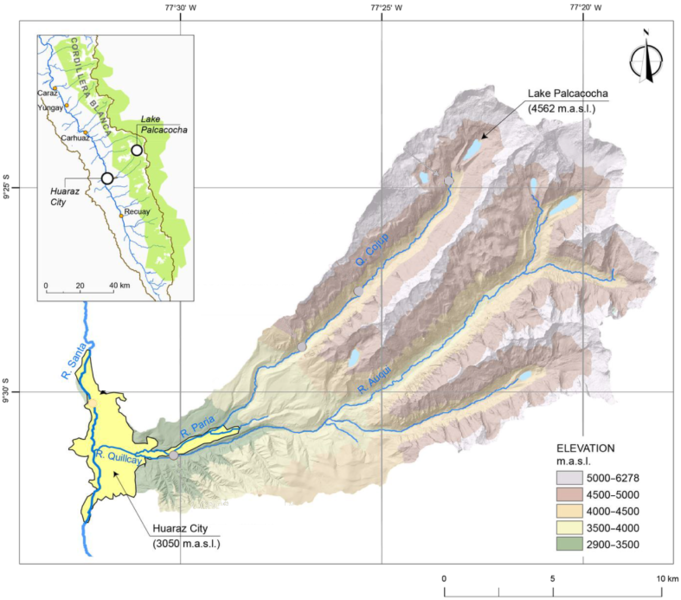
English: Map of the Quillcay watershed, including the city of en:Huaraz and Lake en:Palcacocha. Based on a digital elevation model.
Deutsch: Karte des Wassereinzugsgebiets des Rio Quillcay, mit der Stadt de:Huaraz und Laguna de:Palcacocha, basierend auf einem digitalen Höhenmodell. |
| Data | |
| Origem | Somos-Valenzuela et al. "Modeling a glacial lake outburst flood process chain: the case of Lake Palcacocha and Huaraz, Peru". In: Hydrol. Earth Syst. Sci., 20, 2519–2543, 2016, figure 1. DOI: 10.5194/hess-20-2519-2016 . Based on digital elevation model (DEM) of the Quillcay watershed. Modifications: indications of cross sections blended with surrounding colors) |
| Autor | Original image: Somos-Valenzuela et al., modification: User:DeWikiMan |
The material has been made available by the journal under a creative commons attribution license, for the license policy see https://www.hydrology-and-earth-system-sciences.net/about/licence_and_copyright.html
Licenciamento
A utilização deste ficheiro é regulada nos termos da licença Creative Commons - Atribuição-CompartilhaIgual 3.0 Não Adaptada.
Atribuição: Original image: Somos-Valenzuela et al. "Modeling a glacial lake outburst flood process chain: the case of Lake Palcacocha and Huaraz, Peru". In: Hydrol. Earth Syst. Sci., 20, 2519–2543, 2016, figure 1. DOI: 10.5194/hess-20-2519-2016 . Modifications of original: indications of cross sections blended with surrounding colors
- Pode:
- partilhar – copiar, distribuir e transmitir a obra
- recombinar – criar obras derivadas
- De acordo com as seguintes condições:
- atribuição – Tem de fazer a devida atribuição da autoria, fornecer uma hiperligação para a licença e indicar se foram feitas alterações. Pode fazê-lo de qualquer forma razoável, mas não de forma a sugerir que o licenciador o apoia ou subscreve o seu uso da obra.
- partilha nos termos da mesma licença – Se remisturar, transformar ou ampliar o conteúdo, tem de distribuir as suas contribuições com a mesma licença ou uma licença compatível com a original.
Histórico do ficheiro
Clique uma data e hora para ver o ficheiro tal como ele se encontrava nessa altura.
| Data e hora | Miniatura | Dimensões | Utilizador | Comentário | |
|---|---|---|---|---|---|
| atual | 09h57min de 20 de maio de 2018 | | 4 724 × 4 159 (3,01 MB) | DeWikiMan | {{Information |description ={{en|1=Map of the Quillcay watershed, including the city of en:Huaraz and Lake en:Palcacocha. Based on a digital elevation model.}} {{de|1=Karte des Wassereinzugsgebiets des Rio Quillcay, mit der Stadt de:Huaraz und Laguna de:Palcacocha, basierend auf einem digitalen Höhenmodell.}} |source =Somos-Valenzuela et al. "Modeling a glacial lake outburst flood process chain: the case of Lake Palcacocha and Huaraz, Peru". In: Hydrol. Earth Syst... |
Utilização local do ficheiro
A seguinte página usa este ficheiro:
Utilização global do ficheiro
As seguintes wikis usam este ficheiro:
- de.wikipedia.org
- es.wikipedia.org